

THE OWNERS OF WATER, ADDITIONS TO THE WATER NETWORK, AND WATER MANAGEMENT
The issue of the history of water in Ottoman Istanbul could be delineated in detail under a variety of subtitles. As “water” is the point in question here, required areas of study include the owners, the management of water, waqf (foundation) water and its supply services, water facilities, and water distribution. All of these are denoted in detail in the following sections.
The people who supplied the water of Istanbul were called ashâb-ı miyâh (owners of water) or erbâb-ı miyâh (competents of water) in documents. They supplied the water they discovered in the form of waqf main water conduits to the residents of Istanbul. The major water suppliers were sultans, female members of the ruling dynasty, grand viziers, viziers, and sheikhs al-Islam. Among these people it was the ruling elite, namely the military class, which had the majority share.
While water owners met their own needs with part of the water they obtained, they also had to allocate the rest for the need of the city. They apportioned some of the water from excavated (hafr) wells (âbâr) and from springs to nearby water conduits belonging to the waqfs as “the dike’s share” (hakk-ı mecra). They would annex the water they discovered on a masura1 basis. They would either divert the water to their house or property, or else obtain a certificate of ownership.2
Water owners could not only sell, donate,3 and rent4 their water, but could also bequeath it to someone else. This could be used as rent to be paid later, or for purchased properties, or for inheritance records called “inheritance share records” (defter-i kassam). Among these water owners were the following: palace administrative and finance officials, ministers, governors, officials having duties in ministries, etc. In this way, it is understood that some officials who had duties in various regions of the country spent their retirement periods in Istanbul.
Non-Muslims as well as Muslims mentioned in their waqf charters that they had founded charities in the name of society. Non-Muslims later had to sell the water they had bought in a water ownership period to Muslims. The provision that water ownership and use was under the permission of sultan aimed at preserving the existing order through keeping the issue under control. However, the regulations and limitations that were applied underwent changes over time.5
Various examples show that obtaining and selling water constituted its own economic sector.6 It is known that water was rented from waqfs through the methods of double-renting in cash and via an account (icâreteyn). This method resembled today’s build-operate system and functioned on the basis that the maintenance of the waqfs was the tenant’s responsibility. First of all, the tenant paid the waqf the rent in advance (ücret-i muaccele). With this payment, the required maintenance of the waqf was carried out. Later on, an annual rent installment, called ücret-i müeccele, was paid. Within this rental method, the usufruct of the tenants could be inherited.
In some cases, the obtained water could be connected to a house by paying a certain rent.7 The names of the additions (katma) by people to the waqf water conduits, such as Hagia Sofia, Kırkçeşme, and Sultan Bayezid, were registered. For example, after building the main galleries of the Kırkçeşme water spring, those who wanted to connect water to their house, waqf, or charities in the city could do so by having a well excavated for a spring they had found and connecting it to a conduit in the nearby gallery. Part of the water these people added to the water system was bestowed to them, and the rest remained in the main water conduit as the dike’s share.8
The source of water found in the way described above was private ownership. Regarding privately owned water, the shares of the owner could be dedicated, sold, or rented. The waqfs could also conduct renting.9 With the exception of the Halkalı and Kırkıçeşme Water Conduits built by Sinan the Architect in the name of Sultan Süleyman I (1520–66), the other water conduits were not main water conduits. These were minor water conduits which joined the main water conduits. They are commemorated by the name of charitable person who built them or by the fountain and mosque they reached or the aqueduct they passed through. Out of them, Başhavuz belong to the Kırkçeşme main water conduit, while the Sultan Mehmed II (Mehmed the Conqueror), Mahmud Pasha, Saray-Cedid (The New Palace), Sultan Ahmed, Sultan Bayezid, Sultan Selim, Süleymaniye, and Turunçluk water conduits and water-distribution pipelines belong to the Halkalı network, which is composed of 17 independent water conduits.10
Water Administration and Water Superintendents
During the Ottoman era the highest authority of water organization was the Water Administration (Su Nezareti), which administered public water, water conduits, and people responsible for the maintenance of water conduits (suyolcu).11 Water was under the rule of waqfs, and governed by the administrator of the waqf it belonged to, until 1826, when the Department of Imperial Waqfs (Evkaf Nezareti) was founded.12 The waqfs were regarded as public bodies, but procedures concerning the waqfs had to be approved by the waqf administrator and be conducted according to the administrator’s deed (mütevelli temessükü).
The larger waqfs especially were presided over by state officials such as grand viziers, sheikhs al-Islam, chief finance ministers, Islamic judges, the aghas of the ladies’ apartments in the palace (Darüssaade agha), the aghas of the sultan (Babüssaade agha), the aghas of the interior palace service (Enderun), and the nakibü’l-eşraf (the head of the descendents of Muhammad).13 Again, in the waqf-water period the Imperial Water Superintendent (Hassa su nazırı) or the Water Staff Superintendent (Suyolcular nazırı) was assigned as the top manager. It is understood that superintendents of water were primarily responsible for Istanbul, Eyüp, Galata, and Üsküdar. Therefore, the Water Superintendent was far more than a general director of the Istanbul Water and Sewage Administration (İSKİ) in the current sense; he was also like the general director of the State Hydraulic Works (DSİ). In lower departments, staff was employed to maintain the water conduits.
In this period, the Superintendent of Water was one of the three expert assistants of the mayor (şehremini) who performed municipal services and was accountable to the central administration. The experts were the head architect, the superintendent of water, and the wasteyard official (çöplük subaşı) who was responsible for the cleanliness of the city.14
The Water Administration, which had been charged with waqf water services and which was independent until the Tanzimat period, was reorganized by Sultan Mahmud II (1808–39) and was subordinated to the Department of Imperial Waqfs on 22 February 1837. Water management was the duty of the Istanbul Municipality, which was founded in 1855, and repair and maintenance were the duties of the Ministry of the Imperial Waqfs.15 In the year 1869, all responsibilities were assigned to the Istanbul Municipality.
Waqf water, through the 1876 Municipality Act, became the duty of the municipality. With the regulation enacted in 1880, one water minister, one head secretary, two assistant secretaries (refik), four discovery clerks (selected once every two years from the water maintenance staff), six keepers, two overseers, two reservoir guards, one caretaker, one sergeant (bölükbaşı) per conduit, maintenance clerks, one foreman, and many apprentices were assigned to work.
Through the second Constitutional Period (1908), waqf water management was again subordinated to the Ministry of Imperial Waqfs.16 Today, the water supply of cities is the duty of municipalities. Where there is no municipality, senior village boards are responsible for water issues. The first article of the Water Management Act of 28 April 1926 was about this topic.17
Water Chamberlains, Overseers, and Scribes
There are various records about the duties and obligations of the people employed by the Water Administration. One of them is the register of “the distances of the basins and aqueducts near the public reservoirs and the regulations on fountains and water conduits.”18
This roll explains the duties of the officials working in the administration of the Water Administration. Accordingly, the commission of the Water Administration consisted of one superintendent, one head secretary, two assistant secretaries, four discovery clerks, four keepers, two caretakers, two reservoir guards, one maintenance clerk, and one courier clerk.
Water conduit chamberlains were senior officials who served as assistants to the Superintendent of Water. This position was abolished when the Water Assembly was founded.19 The documents registered some members of the Water Assembly. Discovery clerks were responsible for discovering and examining water conduits inside and outside of the historical peninsula of Istanbul, for price-setting, for overseeing the apportioning and distribution of water, for supervising clerks responsible for water conduits, and for extinguishing fires. It was discovered that the estimates of quantities and costs prepared by the discovery clerks were not reliable and, therefore, waqf estate engineers were assigned to duties concerning waqf estates.
Guards
Guards watched the main conduits of water outside of Kırkçeşme and Halkalı, which were outside of the historical peninsula of the city, and they watched additional grates and aqueducts as well. They took note of minor repairs and informed the administration about required major repairs. Also, they watched against unauthorized water use for yards, gardens, etc. It was their duty to open or close the gates of the barrage as required. They did not permit building yards and gardens near the reservoirs due to their potentially detrimental effects. Additionally, they were responsible for caring for nearby woods and forests and preventing the cutting of young trees.
Overseers
Overseers informed the administration about the quantity of water in water collection and distribution centers inside the historical peninsula of the city. They also examined whether charity water fountains were operational and assisted discovery clerks when there was a fire. Their final duty was escorting the suyolcu sergeants, foremen, and assistant masters to the department when required.
Reservoir Guards
Reservoir guards were always responsible for watching the reservoirs. Reservoir guards closed the valves (lüle) on the water mains when rain started and opened them when rain ceased. They protected the reservoirs from damage and maintained their cleanliness. They distributed water from the reservoirs in accordance with the specifications of the department and protected nearby imperial mansions.20
Water Conduit Secretaries
Water conduit secretaries were central elements of the Water Administration, just like the superintendent of water, the water chamberlains, and the water conduit overseers. In documents, secretaries from other state institutions are also mentioned. Sometimes the word “scribe” (yazıcı) is used instead of “secretary.”
Water conduits were carefully maintained and they were given a separate institution. It has been mentioned that the senior manager of the institution was the superintendent and in between there were a variety of administrators. Within the institution, new arrangements were made, especially for preventing corruption, and therefore a number of regulations were prepared.21
Waqfs were assigned water conduit staff (râh-ı âbi) to work under the provision of the Water Minister. In order for waqf water to run regularly, the staff was allocated salaries for their service. 22 The water conduit staff who worked in the sultanic waqfs was called sergeant (bölükbaşı/serbölük) and the staff of the other waqfs was called “masters” (usta). In order for water to run, discovery clerks, guards, overseers and reservoir guards were employed. 23
In a document which deals with the organizational structure and working principles of water conduit artisans, it is seen that the number of the sergeants of the water conduit artisans and masters reached 250. This document listed the reasons for members of the water conduit staff neglecting their duties and the punishment for malpractice on the part of water conduit staff.24
The Taksim water system started from Yeniköy in the Bosporus. It was divided into thirteen zones under either sergeant or a master until it reached the Imperial Arsenal. There were four service units leading to Tarabya, Galatasaray in Pera, Galata New Mosque, and Hasköy and Sütlüce on the shore of Golden Horn that were not part of the Taksim water system. Instead, they were included in the Halkalı water system. They had their own zonal administration under a master and their waqfs were separate.
Regarding the Üsküdar water system, the waters flowing from Kadıköy—including the vicinity of Üsküdar—located on the Anatolian side of the Bosphorus up to Paşabahçe towards the Black Sea were under the administration of fifteen sergeants.
Sergeants and their masters were granted patents (berat) and they each had from one to seven or eight overseers under their command. The number of the staff was proportional to the volume and significance of each of their service responsibilities, and was related to their distance from the historical peninsula of Istanbul. In the services of these sergeants and masters, fifty Muslim and twenty Christian personnel were recruited. In some of the service zones there were two or three masters in charge of the service due to the size of these zones. The total number of all these water conduit artisans, sergeants, and masters was 250.
WAQF WATER CONDUITS AND WATER CONDUIT SERVICES
In the Ottoman period, the Eyüp Court, as a specialized institution, dealt with water issues concerning Istanbul and sometimes concerning the whole country.25 Not only in regions under the authority of Eyüp and Haslar Kadı Court, but for the whole of Istanbul, Galata, and Üsküdar, all the records about water were kept in the Eyüp Kadı Court.
A significant quantity of the documents belongs to this court’s records. These documents contain information about the springs and streams that supplied the water, the course of the conduits, villages near water conduits, and water facilities such as aqueducts and water gauges.
The essence of these records is as follows: water conduit officials visited the addition to the water conduit with a court-assigned secretary and examined it. They took note of the procedures concerning water belonging to the owner, and then water owners received title-deeds from the Islamic court. The title-deed was registered to the Chief Accounting Office via the head overseer of the Imperial Council (Divan-ı Hümayun çavuşbaşısı), and its certificates were registered by the Superintendent of Water. The respective owner was also given a copy. The procedures around providing owners with title-deeds from the Eyüp Court ended in 1838. From that date onward, the procedures concerning water were transferred to the Waqf Estate Treasury Securities Department (Evkaf Hazinesi Senedat Dairesi). This could be seen as one of the results of the centralization of the bureaucracy. 26
According to Islamic law, with the exception of rivers and natural water resources, water obtained under the ground through efforts and capital could be sold. Thereby, water became privately owned and was subject to endowment as waqf, sales, rentals, donations, and abandonment. Likewise, though waqfs could conduct similar procedures on the endowed water, conditions stipulated in the deed of trust were prioritized.27 A variety of examples concerning these procedures were handled under the “Waqf Water Conduits” title.
In Istanbul and in “the Three Districts” (Eyüp, Galata, and Üsküdar), there were a variety of endowed water conduits whose appendages had revenue sources called “shops, stores” (musakkafât), “landed property” (müstağallât), and “property for income” (akarât).
The major waqf water was of two kinds. The first was reservoir water. Kırkçeşme and Taksim water were of this type. Rain and underground water were collected in reservoirs near Belgrade village and Bahçeköy in Belgrade Forest. The water was distributed to Istanbul, Pera, and the Rumelian side of the Bosphorus through a network of tunnels made of stone or through viaduct aqueducts.
The second kind was spring water. Halkalı and Üsküdar water were of this type. They came from springs near the city or additional wells. They flowed through different conduits into the city wherein they were then distributed. There were sixteen conduits from Halkalı headed in the direction of Istanbul and there was one conduit that went to Pera. The waqf water in Üsküdar, Kadıköy, and others on the Anatolian side of the Bosphorus were brought from separate conduits from springs and wells.28
The Kırkçeşme and Halkalı water that was brought to Istanbul directly belonged to the Department of Imperial Waqfs. The Terkos and Elmalı water systems, which were activated in the nineteenth century, were run by foreign companies. Only the administration of Hamidiye water was under state control and was subordinate to the Istanbul Municipality.29
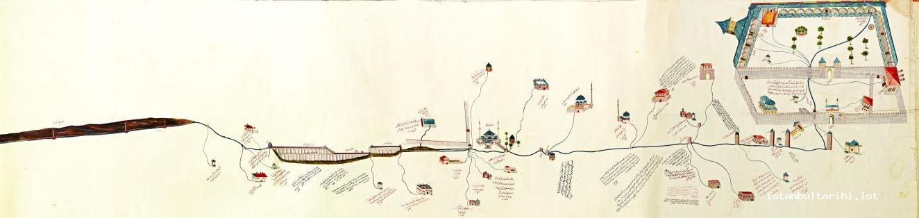
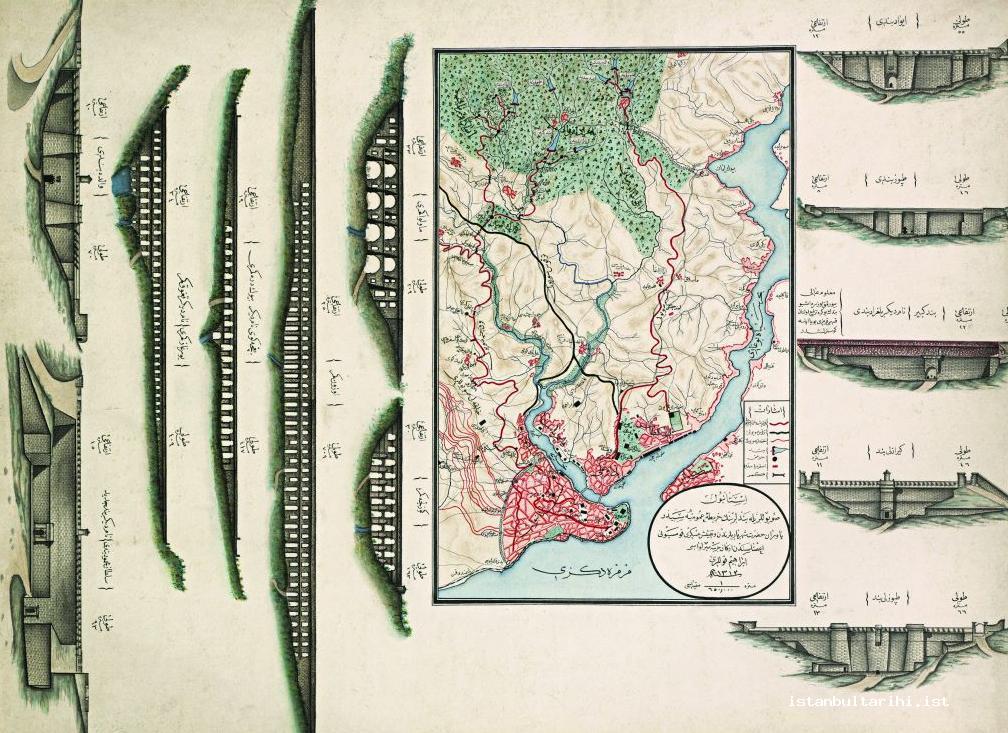
The most valuable documents showing the Istanbul water networks and services are old water network maps. In these maps, the routes the water conduits followed, the fountains, the water tanks with fountains (şadırvan), the mansions, and the Turkish baths they fed are listed along with the quantity of water inscribed on them in lüle (pipe) measures.30
Water conduit facilities were considered as “services” and they were divided into “service” units. In Istanbul and in “the three districts,” each of the water conduit zones within the premises of either sultanic or other charity waqfs and under sergeants and masters was called a service. Therefore, water conduit servicemen were called hademe (servant). Each service zone covered a several quarter of Istanbul, and their sergeants and masters were subsidiaries of a waqf.31 These hidmets assigned water conduits to servicemen.32
In the last days of Ottoman Istanbul, a total of thirty six water conduit service units were constituted (for Kırkçeşme water there were twenty two, and for Halkalı, Taksim, and Üsküdar water there were fourteen). Each service unit had one water conduit serviceman; some of these servicemen had one or two stewards (suyolcu kalfa) because of their heavier tasks.33
These services have interwoven the historical peninsula of Istanbul like a web because of their underground water conduits. Thanks to the facilities constituted, from Ahırkapı to Yedikule and from Eyüp to Eminönü houses were connected by way of water conduits. When the quarters and streets are considered in relation to these service zones, this phenomenon can be clearly seen.
The water services of the Kırkçeşme water conduits from the central conduit at the Eğrikapı water dispenser to the Tezgahçılar water conduit were called Yukarıanacı. And the water services of the Kırkçeşme water conduits from the Tezgahçılar conduit to the Hagia Sophia conduit were called Aşağıanacı.34
The water conduit services lists did not only show fountains in use, but also showed places like mosques, religious convents, schools, and army barracks. As a matter of fact, the service zones were originally arranged to meet the water demand of a particular place, as stipulated in the charity deed.
These service zones constituted water distribution centers in the historical peninsula of Istanbul (Fatih-Eminönü) and the region of Eyüp. They included certain quarters. The streets and alleys of these quarters were interconnected through underground water conduits (tahte’l-arz lagm u kanavat). When there was a need to bring water to fountains, Turkish baths, mansions, seaside residences, or houses, a certain procedure was to be followed and a hüccet deed was issued. While the districts within a service zone might vary over time, they still give an idea about the large area covered by the interconnecting service zone.35
Halkalı Water (1453–1755) and Water Conduit Services
The construction of the Halkalı water conduit began shortly after the conquest of Constantinople in 1453, and the conduit continued to be expanded until the middle of the eighteenth century.36
After the conquest of Constantinople, the population of the city grew and existing water facilities became insufficient. Sultan Mehmed II (1451–81) reformed the water facilities constructed by former Roman emperors Valens (364–78) and Theodosius (379–95), and therefore had the Fatih and Turunçluk water conduits constructed.
Though Kırkçeşme was the primary conduit to serve Istanbul, Halkalı water had historical priority. Halkalı water was almost the size of Kırkçeşme water.37 Hence, the daily productivity of these facilities was 4.335 cubic meters and they met the need of the regions they fed.
While Halkalı water supplied the drinking water of quarters on a higher altitude and mosques, imarets, madrasas, Islamic monasteries, public fountains, and some mansions and houses, Kırkçeşme water supplied drinking water to Eyup and to locations inside of the historical peninsula of Istanbul that were on a lower altitude.38
Halkalı water came from underground. Its springs were clean and it was interconnected to the city through closed pipe drains or lead pipes. There were seventeen water conduits which transmitted Halkalı water to higher places and which were perpetually enlarged until the eighteenth century.39
The drainage basin for the Avasköyü (Atış Alanı), Çıfıtburgaz (Bağcılar), Davutpaşa, and Cicoz Farm (Taşlıtarla) regions in between Halkalı and Cebeci villages was situated outside and to the west and northwest of the historical peninsula of Istanbul. Sultans and statesmen between the years of 1453 and 1755 built these water conduits. While they once consisted of seventeen independent water-distribution pipelines, they were reduced to sixteen pipelines when the Mahmud Pasha and Laleli (Mustafa III) water-distribution systems were combined. If one were to include the Galatasaray water conduit running toward Pera, the number increases and becomes seventeen. Some of the water conduits connected to them and memorialized by the charitable people who built them have since been united.40
The water needs of big Islamic social complexes were supplied by these facilities. The reach of the water to Istanbul was enlarged by the addition of aqueducts. The most important aqueducts connected to the Halkalı water conduits were the Beylik and Süleymaniye water distribution line, the Mazulkemer and Bozdoğan (Valence) Aqueduct from the Roman period, the Avaskoy Aqueduct (Tekkekemer, Yılanlıkemer, Atışalanı) built by Sinan, the Ali Pasha Aqueduct (Çiftekemer, Şirinkemer, probably built in the eighteenth and nineteenth century), the Kumrulukemer Aqueduct (100th Year Quarter), the Turunçluk Aqueduct (no longer in existence), the Kahveci Aqueduct (near Cebeci Village), and the Pasha Aqueduct.41
While by the beginning of the twentieth century the daily flow rate of Halkalı and Turunçlu water was supposed to be 4,860 tons, in the summer months it decreased to 600 tons and in winter to almost 1,200 tons. The basic reason for this was the inability to carry out regular maintenance on them.42
Some of the seventeen water conduits that carried Halkalı water have been united over the years. The following is a list of these conduits:43 Mehmed II the Conqueror and Sultan Selim water conduits; Turunçluk water conduits; Mahmud Paşa and and Laleli water conduits; Beyazıt water conduits; Galatasaray water conduits; Old Mustafa Pasha water conduits; Cerrah Pasha water conduits; Süleymaniye (Süleyman I, the Magnificent) water conduits; Ebussuud water conduits; Zencirlikuyu (Mihrimah) water conduits; Köprülü Mehmed Paşa water conduits; Beylik (Mahmud I) water conduits; Saray Çeşmeleri water conduits; Sultan Ahmed water conduits; Nur-i Osmaniye water conduits; Hekimoğlu water conduits; and Sekbanbaşı Kasım Ağa (Bayrampaşa) water conduits.
Kırkçeşme Water (1554–63) and Water Conduit Services
When a water shortage began as a result of Istanbul’s increasing population, Sultan Süleyman I assigned Chief Architect Sinan to solve this problem. Construction on the Kırkçeşme water facilities began in the year 1555.
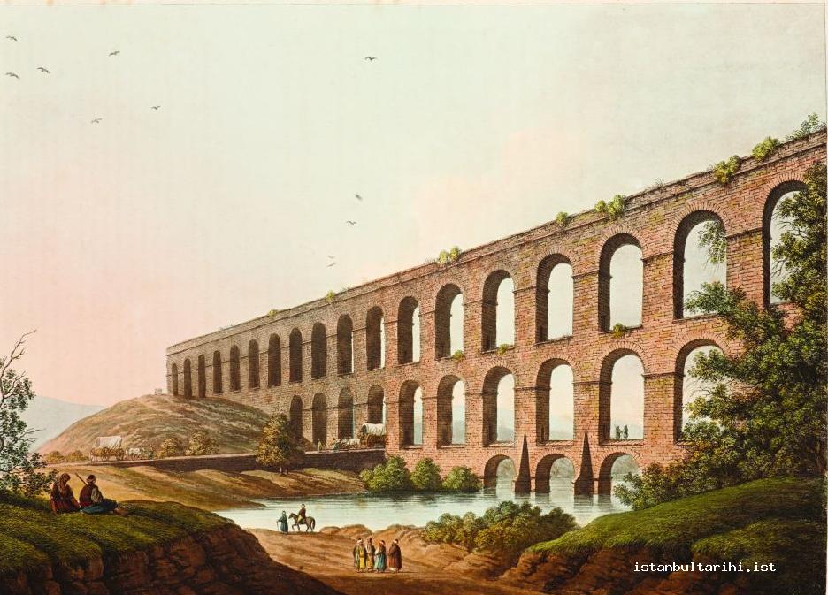
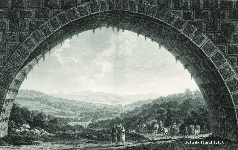
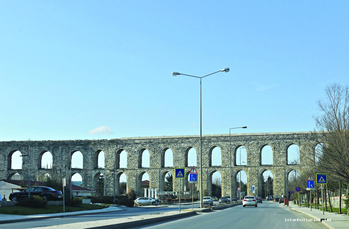
Kırkçeşme water conduits were the greatest and the most important water facilities built in the Ottoman era. They were built in the region around the Kağıthane and Alibey streams on the northernmost point of the Golden Horn. As no pipes capable of carrying water under pressure yet existed, aqueducts were built in valleys and water flowed over them. It turned out that the sophisticated measurements and calculations done to determine the main drains and to build water conduits, aqueducts, and reservoirs were as sensitive as those done by current modern devices today.44
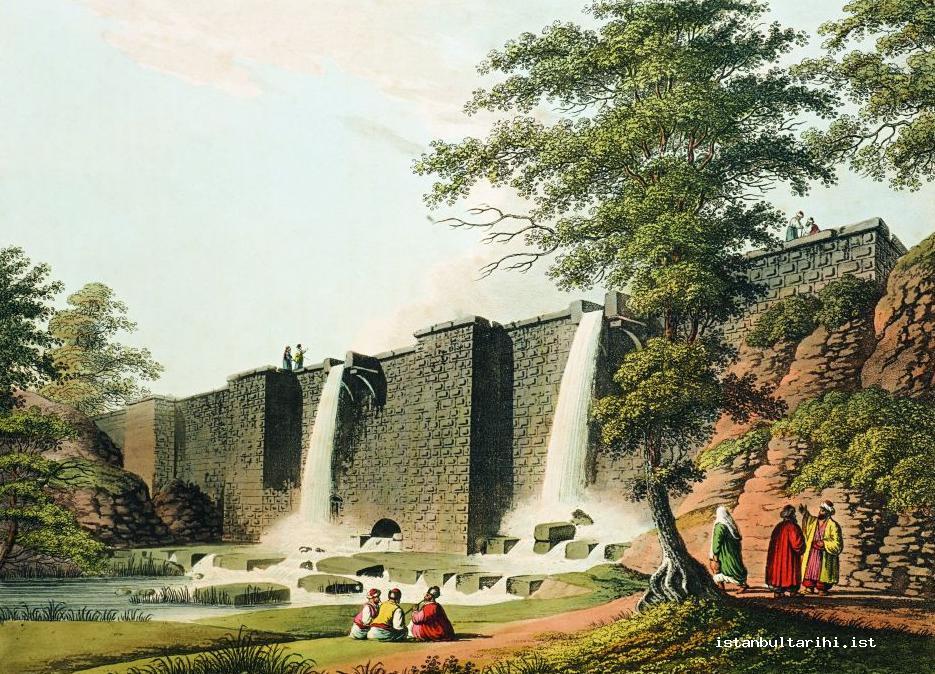
In the facilities completed in 1563, there were four large aqueducts: Uzunkemer, Eğrikemer, Güzelcekemer, and Mavlova aqueducts. Kırkçeşme water facilities fed 158 facilities—including 94 fountains, 19 wells, 15 conduits, 13 public baths, and 7 palaces—with daily water measurements totaling 4,200 cubic meters of water even in the driest times. With the additions done by several charitable people following Süleyman I, the amount of water and the number of facilities increased. By building reservoirs at the heads of streams where water was collected, water was preserved from winter to summer. These four reservoirs that comprised the Kırkçeşme reservoir in the Belgrade Forest were the Karanlıkbent (Osman II, 1620), Büyükbend reservoir (Ahmed III, 1723), the Ayvad reservoir (Mustafa III, 1765) and Kirazlıbend reservoir (Mahmud II, 1818). The daily productivity of Kırkçeşme water increased to ten thousand cubic meters with these reservoirs.
These facilities were first built by Sultan Mehmed II.45 Following the conquest of Istanbul, he ordered that new facilities be built that were comparable to those that had been built by Theodosius I. He drained the water in Belgrade Forest to the historical peninsula of Istanbul to meet the demand of 50,000 inhabitants who were dependent on cisterns. The building of new water conduits was also ordered. Thereby, the twenty-five kilometer water distribution pipeline was renovated and twenty one aqueducts along the route were re-built. The inner-city water network was enlarged to supply water to the imaret complexes of waqfs built by both Mehmed II and the dignitaries of the age. In the section of the historical peninsula of Istanbul being mended, water was drained to Kırkçeşme and directed toward the Golden Horn from Gazanfer Ağa Madrasa under the Bozdoğan Aqueduct. The Kırkçeşme facilities built by Mehmed II were destroyed when Atatürk Boulevard was constructed in the year 1943.46
These new Kırkçeşme facilities, which constituted the main water network of Ottoman Istanbul, stood in the Belgrade Forest region to the north of the city.47 Kırkçeşme was the greatest and the most perfect water facility of the age. It had water collection systems, sediment tanks, water distribution facilities, a main water distribution pipeline which consisted of forty-six kilometer long galleries and clay pipes, a several kilometer inner-city water network, and plenty of fountains. The sensitive slope was applied at a 1/1000 level to bring water toward the city along the water distribution pipeline.
Kırkçeşme water facilities cost a total of 50,057,207 silver akçe. The cost could be calculated in terms of its silver value. As these fifty million silver Ottoman coins corresponded to about one quarter of the yearly Ottoman budget at that time, one has a better idea about the magnitude and significance of the Kırkçeşme water facilities.
From reading the distribution rolls belonging to Sinan about the allocation of Kırkçeşme and Kağıthane water dated 1568–69, it is understood that at that time the daily flow rate of the facilities was 81 lüles (4,212 cubic meters). However, in the days that followed, four reservoirs were built and added to the facilities, thereby increasing the daily water capacity to 334 lüles (17,368 cubic meters).
Kırkçeşme water was drained in the direction of Istanbul and Pera via separate courses. The water drained in Istanbul’s direction was transferred through the Topuz Reservoir, the Büyükbend Reservoir, the Kirazlıbend Reservoir (Sultan Mahmud Reservoir) and the Ayvad Reservoir.
The water transferred in the direction of Pera was collected through three reservoirs called the New Reservoir (Bend-i Cedid), the Valide Reservoir and the Topuzlu Reservoir. This conduit was later named Taksim water conduit and was subject to a separate organization.
By the end of the fifteenth century, the population of Istanbul, three-fifths being Turks, had reached 100,000 people. By the sixteenth century, the population was still 100,000, but by activating the new Kırkçeşme reservoir, the population was expected to grow more rapidly. Thereafter, it is claimed that the population of the historical peninsula of Istanbul reached half a million by the end of the sixteenth century.48
It is known that the grand vizier of the period, Semiz Ali Pasha (1561–65) was against the construction of the Kırkçeşme. He claimed that if the city was provided with abundant water, the population would rise through immigration and that therefore provisioning the city would become difficult, the soldiers would encounter hardships in their livelihoods, the official price-setting system (narh) would be destroyed due to the rise in demand, and rural land would be left uncultivated.
The length of the Kırkçeşme water distribution pipeline from the four aqueducts near Belgrade village to Eyüp Yenikubbe was approximately forty three kilometers.49 It can be estimated that the expenditure for these facilities was more than half of the budgetary revenues (and expenses).50 135 fountains built after the facilities were completed were not included in that total. According to Sinan, the number of fountains built later exceeded 300.51
The Kırkçeşme water conduits consisted of two parts under the names of the Süleymaniye and Genoese water conduits. The first part was the water conduit built by Süleyman I in the years 1544–55 (AH 932), and which started in the direction of Ayvad and Belgrade and ran until the Güzelce Aqueduct of Cebeci village. The second part was the water conduit known as the Genoese water conduit, which ran from Cebeci village to the division in Hagia Sophia Square belonging to the Hagia Sophia Foundation.52
The water of reservoirs of the Kırkçeşme water conduits united the main two branches of the water collection center called Başhavuz. After being cleared of sediment, it would follow a general course, passing through a lot of aqueducts such as Mavlova, Güzelce, and Balıklı. On the way it was enriched by water resources and additions, passing through Sepetlihan Tunnel until it reached the Sinekli Aqueduct near Eyüp and the Yenikubbe water collection area. Here, after supplying the water of the Eyüp vicinity, it connected with the large Eğrikapı water collection center called Savaklar. Kırkçeşme water entered the city in two branches. This route took eight hours for the water to reach its destination.53
The Kırkçeşme water conduits, from the Başhavuz to the Yenikubbe divisions, had various additions to the water system from resources nearby. Different routes were added and the distribution of water started from Yenikubbe.
The water being divided into branches allowed it to feed a variety of quarters. The water need of various mosques, madrassas and imarets was being supplied from Kırkçeşme water.54 The basic branches mentioned in the documents are the Hagia Sophia branch, the Balat branch, the Karagümrük branch, the Nişancıbaşı branch, the Tahtakale branch, and the Samatya branch. Among them, for mosques and Islamic social complexes, there were branches such as Fatih and the New Mosque.
From the Kırkçeşme division, three ways split off: one went in the direction of Tahtakale, Yenicami, and Küçükpazar; the second went in the direction of Aksaray; the third was a main way that went to the division in Hagia Sophia Square. The conduits which split off from the Hagia Sophia division were the following: Topkapı Palace (with the water distribution system of the palace and Ishak Pasha), the Royal Mint, the old Medical School, Demirkapı, Babiali, Hoca Pasha, and Topkapı.55
Water facilities on Kırkçeşme water conduits underwent repairs and additions through time. The greatest construction on facilities on Kırkçeşme water conduits was carried out during the reign of Sultan Ahmed III (1703–30), when the existing water facilities were renovated completely and five reservoirs were added. The Great Reservoir on Topuzdere was one of the five added reservoirs.
During the reign of Sultan Mustafa III (1757–74), water facilities affected by the great earthquake (1765–66) were repaired and Kırkçeşme reservoirs were added near Ayvad Reservoir in the Evhadüddin Valley.
The last sultan who busied himself with reservoirs was Mahmud II. The Water Administration, which was an autonomous department charged with waqf water affairs, was subordinated to the Department of Imperial Waqfs in 1836–37 (AH 1252).
As a result of the endeavors of the Superintendent of Water, Husameddin Effendi, Kirazlıbent was added to the Kırkçeşme reservoirs situated in Belgrade village while Bend-i Cedid (New Reservoir) was added to the Taksim reservoirs near to Bahçeköy during the years 1838–39 (AH 1254). 56
The Kırkçeşme system carried water from streams and reservoirs into the city. It ran over open ground, and was thus exposed to contamination. The Kırkçeşme network, like Halkalı, started being closed down by the municipality in the 1930s because its city conduits were contaminated by E. coli bacteria. These facilities along with the fountains connected to them were to be destroyed.57
At the beginning of the twentieth century, 150–60 lüles (9,000–9,600 square meters) of water was being distributed to the historical peninsula daily.58
The following were the service zones of the Kırkçeşme water conduits:59
Ahırkapı service, Aksaray service, Aşağıana (Küçük Ayasofya, Kumkapı, Gedikpaşa, Yenikapi, Laleli, Şehzadebaşı, Yedikule, Saraçhane, Beyazıt, and Soğanağa) service, Ayvansaray service, Azaplar service (Fatih, Cibali, and Küçükmustafapaşa), Bali Paşa-Dizdariye–Gedikpaşa service, Çukurçeşme service (Aksaray), Ekşikara service (Aksaray and Fatih), Eyüpsultan service, Hoca Paşa service (Cağaloğlu, Bahçekapı, Mahmutpaşa, and Sirkeci), Ishak Paşa service (Sultanahmed), Kumkapı service, Nahlbent service (Hagia Sophia, Küçük Ayasofya, Çatladıkapı, and Sultanahmed), Sultanahmed service, Tahtakale service, Timurkapu service (Demirkapı and Sirkeci), Yedikule service, Yukarıana service (Fener, Sultanselim, Ayvansaray, Eğrikapı, Fener, and Cibali), Zal Mahmud Paşa service (Eyüp), Zeynep Sultan Mosque service (Hagia Sophia), Sarigez service (Sarıguzel, Yenibahçe, and Aksaray), Küçükpazar service (Unkapanı and Suleimaniye), and Topkapı service (Demirkapı, Hocapaşa, and Sirkeci).
Galata and Taksim Water (1730–1839)
The Taksim water conduit facilities were founded to meet the rising demand of the Galata-Pera region.60 Saliha Sultan, the mother of Mahmud I, was the founder of the Taksim water conduits.
The water problem of Pera’s environment was first solved through the Taksim water facilities built in 1732. Water, which was collected in Bahçeköy and whose daily yield was 800 cubic meters, reached a 2,700 cubic meter water house in Taksim through a twenty kilometer water distribution pipeline. Thereby, it was piped to sixty four public fountains and three şadırvan fountains (water tank with a fountain). These facilities included the Bahçeköy (Sultan Mahmud) Aqueduct, Topuzlu Reservoir, Valide Reservoir, and Mahmud II Reservoir. By the construction of reservoirs, the daily output of Taksim water increased to 3,000 cubic meters.
Taksim water was drained to seaside quarters starting from Yeniköy until Kasımpaşa, Pera, and Galata. This water consisted of water from the Topuzlu Reservoir, Valide Reservoir, and Sultan Mahmud Reservoir (Bend-i Cedid) along with their additions. They were all near to one another. The water of these three reservoirs united in Bahçeköy, passed through the Bahçeköy Aqueduct, and drained in Pera. The Mahmud I Aqueduct and Taksim water collection and distribution center (maksem) were the main facilities of this network.
The construction of these facilities was done carefully as the population of Galata increased. Since about the middle of the sixteenth century, settlement in the region had begun to develop and the population on the seashore sectors of the western side of the Bosporus had started to grow. The available information indicates that the Humbarahane water (1739) was given to Hasköy and Kasımpaşa, whereas Levent Çiftlik (farm) water was piped to Teşvikiye, Harbiye, and the vicinity of Taksim from the beginning of the eighteenth century onward.
On the route of the Taksim water conduits there were some small water collection and distribution centers and subsidiary conduits along the Yeniköy–Beyoğlu route. Sultan Mahmud I (1730–54) built the most important and greatest one of these centers in 1732–33 (AH 1145). Thus, this water supply system was named Taksim maksemi, meaning distribution center. The only water collection and distribution center to give water to the Taksim, Kasımpaşa, Pera, and Galata regions was this large water reservoir. The amount of water it held could have handled the need of the region for five or six months in the twentieth century.61
Again within the Taksim water network, there were not only over-ground water collection and distribution centers like Harbiye and Taksim centers, but there were also underground water collection and distribution centers like Hacı Osman Hill, conduits, water gauges, water tanks, fountains, public fountains, and şadırvan fountains. The fountains in Azapkapı, Dolmabahçe, Tophane, Kabataş, and Maçka, and likewise the şadırvan for fountains in Tophane mosques were within that network. The water network whose main line was Pera had the branches of Yeniköy, Boyacıköy–Emirgan, Rumeli Hisari–Bebek–Arnavutköyü, Ortaköy, Yıldız, and Şişli–Kurtuluş, Beşiktaş, Fındıklı–Tophane, and Kasımpaşa.62
Taksim water conduits were built in four stages:
In the first stage, during the reign of Mahmud I between the years of 1731 and 1732, the water of Balaban stream and Eski Bağlar stream in Bahçeköy was collected; it was transferred over the Bahçeköy Aqueduct and Mahmud I Aqueduct and was brought to the big cistern in Taksim in clay pipes glazed on the inside. It passed through Hacı Osman Hill, Ayazağa, Levent, Mecidiyeköy, Şişli, and Harbiye on the way. The water collection and distribution center at Taksim began to pipe water to the region after this date. After Topuzlu Reservoir was built in 1750, the flow rate of water was increased.
The reign of Sultan Mahmud I was a significant period in the history of water in Istanbul. Until that time, the works of both Byzantine emperors and Ottoman sultans concerning water concentrated on the historical peninsula of Istanbul. Topuzlu Reservoir and Valide Reservoir, which collected Taksim water, were the works of that age. The number of fountains built and connected to Taksim water by Mahmud I, his queen mother, and charitable people exceeded forty.63
In the second stage, during the reign of Abdulhamid I (1774–89), the facilities were repaired. Ghazi Hasan Pasha the Algerian had Topuzlu Reservoir repaired and the water level increased by about three meters. During this phase, clay pipes appeared to be inadequate for carrying water in some places and thus galleries were opened. Grand Vizier Koca Yusuf Pasha too repaired the Valide Sultan Katma (addition built by the queen mother) in the Dutluk quarter of Bahçeköy so as to increase the flow of water.
In the third stage, Mihrişhah Valide Sultan (Queen Mother Mihrişah), mother of Selim III (1789–1807), built the Valide Reservoir on Arabacı Mandırası (the wagoner’s dairy farm) stream in Bahçeköy in 1796. With this reservoir, the total flow rate of Taksim water facilities increased to forty one lüles. Mihrişah Sultana also built a water distribution pipeline to Yeniköy and Kurtuluş and also built plenty of fountains both on behalf of herself and on behalf of her daughter, Fatıma Sultana. When the reservoir was in service, it served a palace, two army barracks, three convents, a bakery, six public baths, seventeen houses, nineteen mansions, and twenty nine fountains in addition to those places that had previously received water from this facility.

In the fourth stage, Mahmud II constructed in the year 1839 Yeni Bent (the new reservoir) on the other branch of Arabacı Mandırası stream, which was also known with his name. As a result, the water of the facilities was augmented and the main pipelines of Taksim water facilities took their final shape in 1839. Mahmud II built two fountains near the reservoir, and the excess water of these fountains was again added to the system.
It can be understood that until the construction of the Bahçeköy water network by Mahmud I in 1732, the water needs of this side of the city were met by local capabilities. The Bahçeköy water network, which had originally been fed by Topuzlu Reservoir, was enlarged and it became a “great division” or “water collection and distribution center,” after which the Taksim quarter took its name, and here the network branched off.64
Since Taksim water was surface water, just like Kırkçeşme water, and mostly fed by Kağıthane Stream, it ran the risk of pollution and becoming undrinkable. Therefore, Abdulhamid II established the Hamidiye facilities (1898–1902) in order to provide the city with good-quality drinking water.65
Sultan Abdulhamid II (1876–1909) paid attention to the water reservoirs from the early days of his reign. He increased the quantity of water and established a large commission in 1881–82 (AH 1297) in order to improve the water quality. However, the financial resources to heighten the walls of reservoirs and to improve water conduits could not be found. In the end, only the water of Kağıthane stream was raised with steam machines and it was added to Taksim water.
Again in the reign of Sultan Abdulhamid II, a new era in the history of the water of Istanbul began. The old water supply system was an engineering miracle. Besides this, the Terkos water supply network, which remained outside the waqfs system, was established in this period.66
Galata and Taksim water conduit services were intended for meeting the water needs of public fountains, mosque-şadırvan fountains, convents, school, madrassas, army barracks, hospitals, police stations, etc.67
Other services were: Beşiktaş service, Teşvikiye service, Çırağan service, Pera service, Tatavla service, Galata Emetullah Valide (Galata New Mosque) local water service, Hasköy spring water service, Ortaköy local water service, Kuruçeşme service, Arnavutköy local water service, Rumelihisari local water service, Emirgan–Boyacıköy service, and Yeniköy service.
Apart from these services mentioned above, documents provide information about service units concerning water distribution and the repair of water conduits, especially in Galata and its vicinity.
Üsküdar Water
The water organization in Üsküdar was mostly an Ottoman work. On the other hand, in the era before the conquest, it is understood that cisterns were used to meet water needs. A cistern thought to be dated after 1261 was found in excavations on the Koşuyolu Ibrahimağa Convent (zaviye) road during the Marmaray metro’s infrastructure and tunnel excavations. A similar cistern was discovered in excavations in Üsküdar.
Üsküdar water, just like Halkalı and Hamidiye water given to the historical peninsula of Istanbul and to Pera, was spring water built on a waqf basis. The relevant document emphasizes this point and mentions that the total rate of flow rose to 30–35 lüles (1,560–1,820 cubic meters) per day.68
However, if all the rates of flow of the conduits in the Üsküdar water supply system were considered, one could estimate that in the Ottoman era, Üsküdar was given more than 50 lüles or 2,600 cubic meters of water per day. If one considers that the daily water needs of a family of five members is generally less than half of a ton, one has grounds for comparison. Again, if one says that the population of Ottoman Üsküdar was 150,000 and the current population of the region is approximately 4,000,000, one comes close to understanding the amount of water per person.
The Ottoman-era Üsküdar water was considered in three parts. First, there was the water of Üsküdar kaza (sub-city district) that today involves the entire water sources of the whole Anatolian side. Therefore, management of these water supplies is within the authority of other municipalities in the present time. Second were the water conduits of central Üsküdar (belde). Third were the water conduits of towns which were once villages and that later became the quarters of Üsküdar.
The water needs of Üsküdar, except a holy spring belonging to the Orthodox Greeks (ayazma),69 were met by at least eighteen water conduits of three to fifteen kilometers in length, whose water was obtained from various resources, some of which belonged to the wives of the sultan and were gathered from the edges of the Çamlıca hills.70
Among the water conduits of the Çamlıca hills, which carried water to Üsküdar, the most significant and greatest ones were the water conduits of Atik Sultana (Nurbanu Sultana, 1583), Nevşehirli Damat Ibrahim Pasha (1718), and Selimiye (Selim III, 1790).
Apart from these, one can mention the water conduits of Mihrimah Sultana (two in total), Solak Sinan, Mahpeyker (Kösem) Sultana (Çinili), Emetullah Gülnuş Sultana (Yeni Cami, Cedid Valide), Mihrişah Sultana (Ihsaniye), Aziz Mahmud Hudayi, Arslan Agha, Selami Ali Efendi, Kapıağası Yakub Agha, Haji Halil Efendi (Çınar), Tophanelioğlu, Ayazma (Sultan Mustafa III), Altunizade, and Paşalimanı (Cevri Kalfa).71
The ownership of the water and wells in the vicinity of Büyük Çamlıca and Küçük Çamlıca hills belonged either to their possessors or to the former waqf administration if they were obtained on waqf land. Among them, the famous Taşdelen water has always belonged to waqfs. Again, the ownership of the others, except for Hasib Pasha, Tomruk Ağası, Ömerbey in the vicinity of Çamlıca, Göztepe in Çubuklu, Simkeş in Beykoz, Hünkar, and Çırçır in Sarıyer, belonged to waqfs.72
There were service units concerning water distribution and the repair of water conduits in Üsküdar and its vicinity, such as Kandilli, Çengelköy, Beylerbeyi-Stavroz, and Kuzguncuk.
Üsküdar waqf water flowed in three branches:
a. The southwest branch: The water collected from Ümraniye, Bulgurlu, and Little Çamlıca reached Üsküdar by way of Altunizade and Validebağ. Its flow rate exceeded 3 lüles (156 cubic meters).73
Among them were the water conduit services of Atik Sultana (Nurbanu Sultana, d. 1583), Selim III (Selimiye), the Grand Vizier Nevşehirli Damad Ibrahim Pasha (1718–30), and Fatıma Sultan (Ahmed III’s daughter whose mother is Mihrişah Sultan, wife of Nevşehirli Damad Ibrahim Pasha).
b. The northwest branch: The major ones were the water supplies from Hudayi, Mihrişah Sultana (Selimiye and Ihsaniye), Tophanelioğlu, Cevri Usta, Refi Effendi, Ismihan Kaya Sultan, Arslan Agha, and Özbekler convent (dergah). This water joined in Üsküdar through Büyük Çamlıca, Tophanelioğlu, Bağlarbaşı, Nuhkuyusu, Posta Yolu, and Bülbl Stream Street. The total of this branch’s water was approximately 3 lüles (156 cubic meters) per day.
c. The north branch: The major water coming to Üsküdar from the northern direction was the water of İskele Mosque (Mihrimah Sultan) in the ferry port. It was carried to the mosque and was brought from seventeen springs situated in Çiftebakkallar and Dereboyu located in Icadiye, in the Jewish cemetery, and in Kuzguncuk stream.74
Again, there was Sultan Mecid water draining into Haydar Pasha Hospital, Altunizade İsmail Pasha, Selami Ali Efendi, Kazasker Refi Efendi, Silahtar Abdurrahman Pasha, Kazasker Baki Effendi, Sheikh al-Islam Mirade Esad Efendi, Eminzade water and Imperial Stables Director Halil Efendi, Çınar fountains, Toygar Hazma and Özbekler convent, Maktul Selim Agha, Karabet Kalfa, Yenimahalle Armenian Church water, the fountains of Mehmed IV in Büyük and Küçük Çamlıcas, Çınardibi of Nahimiye Hanım (daughter of Emin Pasha), Kısıklı fountains, Benlizade Raşid Efendi fountains, Demirci fountain in Bulgurlu, Meleksima fountains and Violinist Talib Efendi, Libade, Suleyman Pasha, and Hatice Sultan fountains, etc.75
Moreover, apart from those, which sprang from the Kayışdağı Stream, there were additional small water conduits. Today almost no water conduits remain and the fountains have been destroyed, too.
Üsküdar waqf water particularly came from Çamlıca hills. The articles of Galib Ata and Nazım Bey about these water conduits provide important information about Üsküdar’s historical topography.
In the title-deeds (hüccet) in the Sweet Water Rolls (Ma-i Leziz Defterleri) and in the Waqf Water rolls, the water and water conduits that fed Üsküdar were registered. In these volumes, there were major sultanic water waqfs, major water conduit services managed by sergeants, and basic water conduits. As is known, the water conduit official of imperial waqfs was called the sergeant.
In Üsküdar and on the Anatolian side, there were no large-scale water distributors and divisions as in Istanbul and Pera quarters. Charitable people allocated water found far away in clay pipes to the villages in Üsküdar and on the Bosporus.76
The information about these water conduits is, at the same time, very illuminating for the topography and toponymy of the Anatolian side of Istanbul during the nineteenth and twentieth centuries.
The water service facilities of Üsküdar were set up by the end of the sixteenth century. But, after the conquest of Istanbul, as in the historical peninsula of Istanbul, Turkish quarters were concentrated in the vicinity of mosques in Üsküdar, too. The mosque and Turkish bath of Rum Mehmed Pasha, one of the grand viziers of Mehmed II, was one of the first mosques of Üsküdar as well as the whole of Istanbul.
Apart from that, Kaptan Pasha (Hamza Fakih), Davud Pasha (1505), Selman Agha (1508), and Mihrimah Sultan (1548) mosques were the first mosques of Üsküdar. The water needs of these mosques must have been met by underground water brought by small galleries, and stream water such as Bülbül Stream, Balaban Stream, and Çavuşdere. Plus, modest resources such as the water from small galleries dug in hills could meet the needs of the non-crowded city. 77
Considering these mosques, one understands that Üsküdar became crowded due to the close distance of the port. Taking the construction dates of mosques into account, it is possible to determine the approximate formation periods of the quarters of Üsküdar. Mihrimah Sultan Mosque Complex’s completion in 1547 probably denotes that the port and its vicinity were populated by then. The construction of other mosques was also closely related to settlement in the vicinity. One may assume that waqf water conduits were established in this period as well. Thus, the Rum Mehmed Pasha Waqf was most likely formed primarily for its own water conduits.
For the water needs of charities such as public fountains, mosque-şadırvan fountains, convents, imaret complexes, schools, madrassas, army barracks, hospitals, and fire pools there were the service zones of Üsküdar, Kuzguncuk, Kısıklı, Atik Sultana, Debbağlar, Çakırcı Hasan Pasha, Sinan Pasha (Ihsaniye), Ümraniye–Yalnızservi, and Bulgurlu.
The water conduits of Üsküdar were as follows:78 Atik Sultana (Nurbanu) water conduits (1583), Çinili (Mahpeyker, Kösem) Sultana (Middle Sultana) Water Conduits (1640), Nevşehirli Damat Ibrahim Pasha and Fatıma Sultana water conduits (1718), Selimiye water conduits (1800–05), Mihrimah Water Conduits (around 1547), Gülnuş (Emetullah) Sultana (New Sultana) New Mosque water conduits (1640), Mihrişah Sultana (Ihsaniye quarter) water conduits (1791), Ayazma (Sultan Mustafa III) water conduits, Aziz Mahmud Hudayi water conduits, Selami convent (zaviye) water conduits, Tophanelioğlu water conduits (1832), Altunizade water conduits, Eminzade water conduits, Solak Sinan water conduits (1547–48), İsmihan Sultan and Ismihan Kaya Sultan water conduits, Cevri Kalfa (Paşalimanı) water conduits, Arslan Agha Waqf water (1646), and Çamlıca water conduits.
In the twentieth century, Üsküdar water conduit services were disengaged. Water subscription systems became widespread and old Üsküdar water survived only in the form of spring water. The leading one among them was the Çamlıca water, which was the major source of Üsküdar water.79
There were service units concerning water conduits, water distribution, and the repair of water conduits belonging to the villages in the vicinity of Üsküdar. Of these, the ones within the administrative premises of contemporary Üsküdar are as follows: Kuzguncuk, Stavroz, Beylerbeyi, Çengelköy, Vaniköy, Kandilli, and Küçüksu services.80
The water conduits and water services of Üsküdar that fall within the scope of other municipalities today are as follows:81 Kanlıca–Anadoluhisarı water conduit service; Beykoz water; Paşa–Paşabahçe service; Kadıköy water and water conduit services;82 Kayışdağı Water; Kartal-Pendik Water, and Tuzla–Gebze Water.83
Hamidiye Water (1902) and Spring Water in Istanbul and Its Vicinity
Various spring waters were diverted through small water distribution pipelines to fountains in order to meet the city’s need for drinking water. The most important of these was the Hamidiye water pipeline built by Abdulhamid II in 1902. Its productivity was 1,200 cubic meters per day. The Hamidiye (Kağıthane) network was formed by collecting the water of approximately sixty springs near Karakemer in the valley between Kemerburgaz and Cendere (1902). This water was distributed to army barracks, palaces, and about fifty fountains near Pera.84
The Hamidiye water network reached Taksim and extended to Yüksekkaldırım, Şişhane, and Galatasaray. Since the Bahçeköy network could not supply Galatasaray, authorities began to inquire into the matter by 1851, but only toward the end of the nineteenth century was a branch of a water network that drained from Lake Terkos allocated for the regions of Galata and Pera as a solution.85
This water was carried and distributed in pig-iron pipes. It is known that this water was pumped to the tower between Şişli and Büyükdere by machines, and through the catch pit in Balmumcu it was distributed to fountains and official buildings on the lower sides of Pera and the Bosphorus.86 The daily productivity of the water was 1,200 cubic meters.87
There was some high-quality spring water. This was used as drinking water.
The most famous sources of superior-quality drinking water in Istanbul were as follows: Hamidiye water obtained from the springs in Kağıthane and Kemerburgaz on the Rumelian side, Dertlipınar water in Ayazağa, Kanlıkavak and Sarıyer water (Çırçır, Kestane, Hünkar, and Tomruk water) allocated to Emirgan from Baltalimanı, Sultan water and Kocataş water in Büyükdere, Kefeli water in Kireçburnu, and Kese water in Alibeykoy.
On the Anatolian side, the high-quality sources of spring water were: Taşdelen water obtained from the resources in Alemdağ, Sırmakeş water, Defneli water, Göztepe water, Alemdağ water, Mütevelli water, Çubuklu water in Çubuklu, Onçeşmeler, Karakulak and Ishak Agha water in Beykoz, Kayışdağı water (which also fed certain fountains), Tomruk water in Big Çamlıca, Küçük Çamlıca water, Ayazma water in Yakacık, and Şeker water.
THE TRANSITION FROM WAQF WATER TO PAID WATER DISTRIBUTION: WATER COMPANIES
Terkos Water
Historical reservoirs and underground water networks run by waqf administrations were replaced by official networks at the end of the nineteenth century. These networks were created by taking water from lakes in the vicinity, such as Terkos, and then transferring the water by way of dams: Terkos water network (1883), Elmalı I Dam (1893), Elmalı II Dam (1950), Alibeyköy Dam (1972), Ömerli Dam (Riva 1968-1973), Darlık Dam (Darlık Şile 1985–89), Büyükçekmece Dam (1982–88), Yeşilvadi converter facilities (1992), Istranca Streams (1995–2000), Şile Keson Wells (1996), and Sazlıdere Dam (1998) met the water needs of the city. Now, historical water networks meet little more than one percent of the need on the European side.88
In order to address the issue of insufficient water and to give pressurized water to modern buildings, Sultan Abdulaziz granted a concession to a French company in 1868; thereby, the “Dersaadet Anonim Su Şirketi (Terkos Şirketi)” (Istanbul Water Incorporated Company) was founded. It was accepted that this company would collect and allocate spring, stream, and underground water, would refine the water to be taken from Lake Terkos, and would allocate and distribute the water in the city.89
The first of the facilities was the Water Elevation Center adjacent to Lake Terkos, built in 1883. In 1888, the connection to heighten the rim of the lake was made. In the year 1926, the first filtration facilities on the ridges of Kağıthane were constructed. The water was chlorinated and then distributed to the city.
The tour to Europe by Abdulaziz was an important step in meeting the water needs of Istanbul. Abdulaziz toured London, Paris, and Vienna in 1868 and when he was in Paris he was shown the hydraulic facilities that pumped water to the city from the river Seine.90 During this travel, figuring out how to use Lake Terkos to meet the water need of Istanbul came on the agenda. After Sultan Abdulaziz returned to Istanbul, he ordered feasibility studies to be conducted on the lake water.91
In nineteenth-century Istanbul, concessions had already been given to a number of companies in order to filter lake, dam, and stream water and to distribute it both to the Rumelian side and the Anatolian side of Istanbul. The projects that were approved for the Rumelian side of Istanbul were the ones about improving Lake Terkos and the streams that fed the lake to use them as drinking water. Therefore, in 1873, Istanbul Kızıldere Company was founded by a concession edict and contract in order to distribute water to Pera, Galata, the western shores of the Golden Horn, the Rumelian side of the Bosphorus, and to the historical peninsula of Istanbul. The duration of the concession of the company was forty years.92
Later, during the reign of Abdulhamid II, Dersaadet Water Incorporated, known as Terkos Company, was founded and its institutional rules and regulations were issued. As mentioned in the contracts, the company was made the sole authority to undertake construction and repair concerning the transfer of drinking water from Lake Terkos and Kızıldere to Istanbul, Pera, Galata, and the villages on the Bosphorus. The company consisted of non-Muslim partners.93
Following these stages, it was decided that the Dersaadet Water Incorporated would be in force for seventy five years starting from 1882. In an additional contract signed in 1887, the company was allowed to build reservoirs to collect water from the streams feeding into Lake Terkos as well as spring water in the regions of Terkos, Daye Hatun, Bedlisek, Izliköy, Akalan, Türkköyü, Sinekli, Büyükhan, Ayazmadere, Kışla, Çaydere, Çordere, Elecik, and Karaburun. Nevertheless, the company was neither to interfere with the water that fed into existing reservoirs nor to harm the Imperial Waqf water conduits.94
Moreover, it was stipulated that the company would install fire hydrants at its own expense and supply water to them free of charge. It was also to build twenty small public fountains in the region of Istanbul as it had previously done along the Golden Horn, the Dersaadet shore, the Rumelian shore of the Bosporus, and in Pera. The water supply for these fountains was to be provided free of charge as well. Likewise, the company would pump water to existing and future army barracks, military and civil schools, police centers, military police centers, the Tophane Municipality, and the Haseki Nisa and Yenibahçe Gureba hospitals. A daily allowance of 51.4 kilograms (40 okka) of water per bed would be provided on gratuity.95
As the Terkos network was extended throughout the city, the Kırkçeşme water supply system, which came from Belgrade Forests and supplied only the historical city of Istanbul, was deactivated in the 1940s. The Taksim and Halkalı water conduits that brought water from reservoirs to Pera, however, remained in use. The major water supplier of Istanbul was by that point Terkos water. While it was claimed that this situation would cause water shortage, the decision was based on concerns about public health.
The mayor of Istanbul at the time, Lütfi Kırdar, mentioned that the Kırkçeşme network—the last section of which had been deactivated by that time—distributed water to fifty one mosques, eighteen official institutions, and factories. These fifty one mosques whose water was cut were then supplied by Terkos water. Other official institutions and factories had already been connected to the Terkos facilities. 140 fountains connected to Terkos replaced the 219 fountains that had been fed by Kırkçeşme water.96
Elmalı Water
In general terms, the water supplies of the Üsküdar-Kadıköy region were not piped from a lake as was the case with the Terkos network. They instead consisted of the Elmalı reservoirs and springs.97
There were three separate water supply networks in Istanbul, Pera, and on the Rumelian shore of the Bosporus: Kırkçeşme, Halkalı, and Terkos. On the Anatolian side, however, the water demand increased because summer houses were built alongside the railroad. Thereafter, also on the Anatolian side, investigations concerning use of lake, stream, and dam water as drinking water were conducted. Through these efforts, a concession contract about building reservoirs in Göksu and Paşaköy valleys and about draining water to quarters within Kandilli and Erenköy were signed in 1888. Accordingly, water that flowed from the Göksu valley to Riva would be piped to the Kandilli and Erenköy region by engine power if required. The contract would last for thirty years after the date of signing. Based on that, the Üsküdar and Kadıköy Water Company Charter (Üsküdar ve Kadıköy Su Şirketi Nizamnâmesi) was promulgated. Regulations about the water distribution of Üsküdar and Kadıköy Water Company were promulgated in 1894.98
With the need for water continually rising on the Anatolian side, the Üsküdar and Kadıköy Water Company built Elmalı I Dam in 1893 and built up water networks in the area from Anadoluhisarı to Bostancı. Later, the company constructed a water-treatment plant, an elevation center, a water-distribution pipeline, and a water tank in Bağlarbaşı.
In addition to that, a company contract was signed in 1914. This contract included the concession and regulations about increasing the duration of the concession to ninety nine years and about enlarging the zone of concession to completely cover Kanlıca in the Bosphorus region and Maltepe in the Kadıköy region. Moreover, the company made a commitment in two written statements in 1914 to make the relevant construction in order to pump water up to the quarters of Çamlıca 210 meters above the sea level and to the quarters of Beykoz village 75 meters above the sea level. Meanwhile, a supplement was added to the water distribution regulations of the Üsküdar and Kadıköy Water Company in 1918 explaining the new rules concerning subscribers, water meters, water bills, and payments.99
Investigations for meeting the water needs of Büyükada (Prinkipo) were conducted, too. For this purpose, a thirty-five year concession contract was signed to obtain water from existing and future wells by machine power in the Nizam quarter of the island and to distribute it to the island.100
Terkos and Üsküdar-Kadıköy Water Companies were the starting points of the Istanbul Water Administration and the current Istanbul Water and Sewage Administration.
COLLECTING WATER
Kırkçeşme water, which fed the historical peninsula of Istanbul, was collected in Belgrade Forest, which lies near the Black Sea. In the region of the villages of Küçükköy and Cebeci to the south, it was distributed to the historical peninsula of Istanbul through water conduits enriched by additions to the network. Here, both Alibey and Kağıthane streams were two important resources. Plenty of streams fed these two main streams. There were some “water conduit villages” (suyolu köyleri) in charge of the maintenance of water conduits in the water collection basins from the shores of the Black Sea. These water conduit villages were in the Belgrade Forest and Küçükköy region where Kırkçeşme water was collected.
Halkalı water was the water that came from sources in the vicinity of the city as well as a number of wells that came in via separate routes and were thereby distributed to the city. The water collecting basin region was between the villages of Halkalı and Cebeci, to the west and northwest outside the historical peninsula of Istanbul, and Avasköyü (Atışalanı), Çıfıtburgaz (Bagcılar), Davutpaşa, and Cicoz Farm (Taşlıtarla).
Taksim water that fed the Galata quarter was collected through the streams in the vicinity of Bahçeköy and Balaban villages.
The water needs of Üsküdar were, in essence, met by collecting the resources obtained from the foot of the hills of Çamlıca.
The Hamidiye water network was constituted by collecting approximately sixty sources of water in the vicinity of Karakemer in the valley between Kemerburgaz and Cendere and bringing their water to Taksim.
Water Facilities
The task of maintaining and protecting water conduits and facilities belonged to water conduit villages. The repair of damaged water conduits emerged on the agenda from time to time.101
In the defense of water facilities, their being surrounded by trees had great importance. Today this is seen in reservoirs, too. It must be mentioned that it was a part of the guards’ duty not to let people cut green timber in woods and forests for the reason that it might harm the reservoirs.
Güzelce Wood, Beğlik, Çiftehavuz (Terkos, Kemerler, and Middle Belgrade),102 Hadim and Davud (Kemerburgaz), and Bahçeköy103 woods fulfilled the same function.
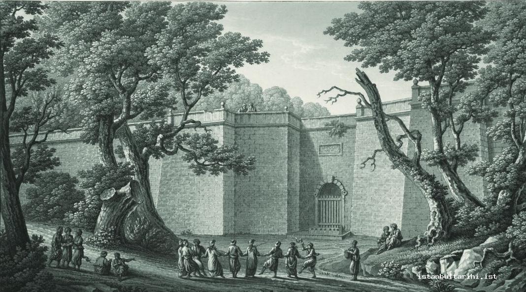
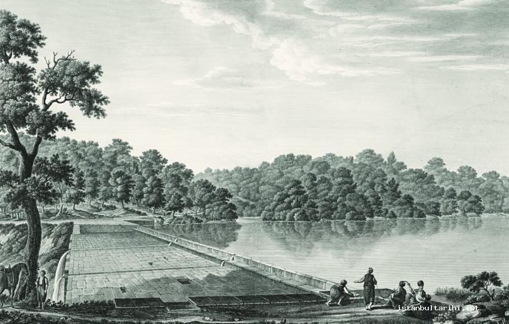
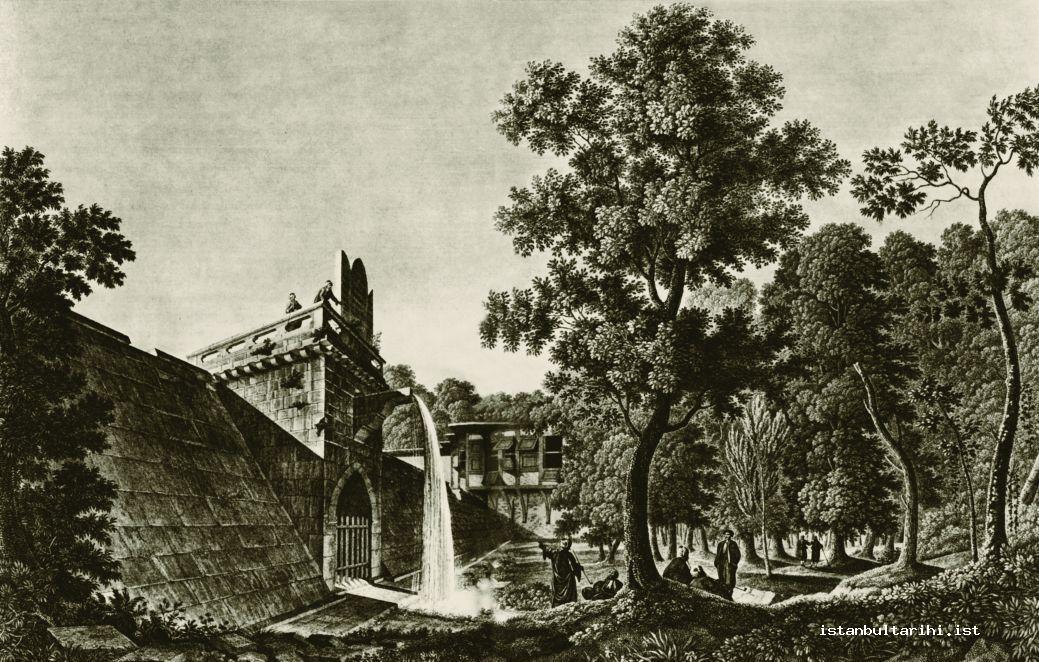
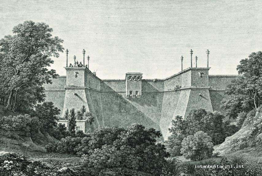
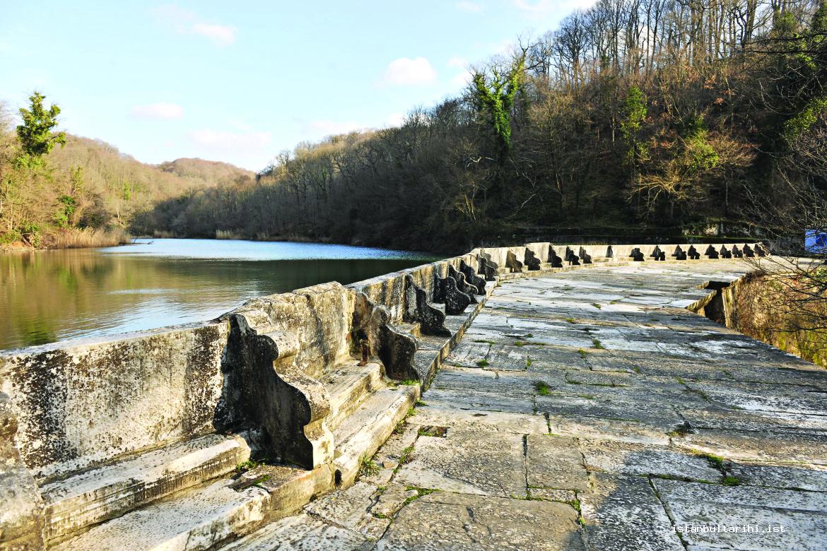
It was not allowed to set up vineyards, gardens, or buildings in the places where there were intact water conduits.104 Important water facilities included reservoirs, pools, aqueducts, grates, barriers, water collection and distribution centers, towers, sluices like the Eğrikapı sluice, inspection shafts, and water tanks like in Pera and Taksim.105
In the Ottoman era, all the facilities that met the water needs of the city were outside the historical peninsula of Istanbul. The majority of them are now located in the present-day districts of Sarıyer, Eyüp, Gaziosmanpaşa, and Esenler. Only the Valence (Bozdoğan) Aqueduct dating from the Roman era, situated in the historical peninsula of Istanbul, carried water to the two high points of the city. Of the aqueducts outside the city, only the Bozdoğan Aqueduct between Mazulkemer Fatih and Suleymaniye survives today.
Aqueducts
Aqueducts were mostly employed in the Kırkçeşme, Halkalı, and Taksim water conduits. Each is addressed in turn below.
Kırkçeşme Aqueducts
Kırkçeşme water was generally carried by aqueducts either built or repaired by Architect Sinan at the behest of Süleyman I.106
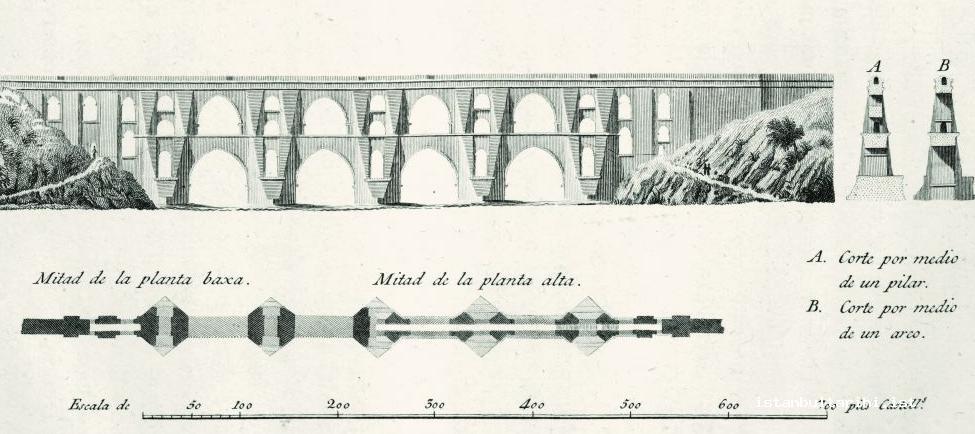
Since Kırkçeşme water originated from the west of Kağıthane Stream and passed through somewhat rough land, there were various other aqueducts used to pass the water across streams and valleys. On this water distribution pipeline there were thirty five aqueducts, five of which were either two or three stories in height: Mavlova (Moğlova, Muallak) Aqueduct, Uzunkemer (Sultan Süleyman Aqueduct), Güzelcekemer, Eğrikemer (Koğuk, Kovukkemer, and Burgaz Aqueduct), and Pasha Aqueduct. Apart from these, there were some aqueducts that were only a single story in height, but which were nevertheless important: Ayvad Aqueduct, Kurt Aqueduct (Reservoir Aqueduct), Karakemer, Kırıkkemer, Balıklıkemer, and Valide Aqueduct.107
Mazul, Bozdoğan (Valence), Karakemer, and Tunçluk aqueducts are Roman aqueducts built in the fourth century.
Karakemer (Cebeci) was repaired in the seventeenth century and the Çınar branch of the Süleymaniye water conduit passed through this aqueduct. This aqueduct was described as dating back “before Derinmaslak,” and is today lost under the remains of a quarry.108 Turunçluk Aqueduct, known to be near Cicoz Farm and used by Mehmed II, no longer exists today.109
There were six aqueducts on the eastern branch where Kırkçeşme water conduits passed over Kağıthane Stream, the most important of which were Paşa Aqueduct and Eğrikemer. Once these facilities were completed, Topuz Reservoir (Karanlıkbend) and Büyükbend and Kirazlıbent were constructed on the eastern branch.
There were three aqueducts on the northern branch, of which Uzunkemer was the largest. On this branch, Ayvad Reservoir was built and as a result the amount of water that was carried to the city increased. Today, the village of Kemerburgaz in the district of Eyüp lies between Uzunkemer and Eğrikemer.
Two branches carried the water of the Belgrade village reservoirs and united in the circular pool built by Osman II (1618–22) near Burgazköyü called Başhavuz. In the beginning, the main conduit for Kırkçeşme water, which came from Başhavuz, was under the ground. Later, while Mavlova Aqueduct was being built, it passed Alibeyköy Stream through this aqueduct. Following that, it moved through the bases of mountains again in this conduit and reached Güzelcekemer (Gözlücekemer). The old Genoese water conduit that remained from the Roman era was at the end of Güzelcekemer and came from Cebeci village. It united with the conduit which Süleyman I built.
In Güzelcekemer three water conduits met. The first was the conduit which came from Başhavuz, the second was the old Genoese conduit which remained from the Byzantine era and came from the vicinity of Cebeci village, and the third was the conduit which came from the direction of Istanbul. Like Uzuncakemer between Petnahor and Burgaz villages, this Güzelcekemer was also built in the age of Süleyman I. Eğrikemer, which remained from the time of Andrenikos Komnenos (1183–85), and Uzunca and Güzelcekemer of Süleyman I constituted three historical and beautiful works on the course bringing the water of the Belgrade reservoirs to the Kırkçeşme water conduits.110
The Kırkçeşme network passed through twenty one small aqueducts constructed by Mehmed II, including Deliklitaş, Aziz Paşa, Cebeci, Arabacı, Viran, Kumrulu, Sarı Süleyman, Çavuşköy, Suludere, Uzunkoltuk, and Çiftekemer. These aqueducts transported the water of five reservoirs built by Ahmed III, and carried them to the Eyüp and Eğrikapı water collection and distribution centers. Their rates of flow were measured when they joined in the city through two galleries which went in two different directions. They were distributed to mosques and fountains through clay pipes.111
In 1563, two of the water aqueducts (Mavlova Aqueduct and Güzelcekemer) were destroyed as the result of heavy rainfall and floods. These aqueducts were later re-built, and the system was once again supplied with water.
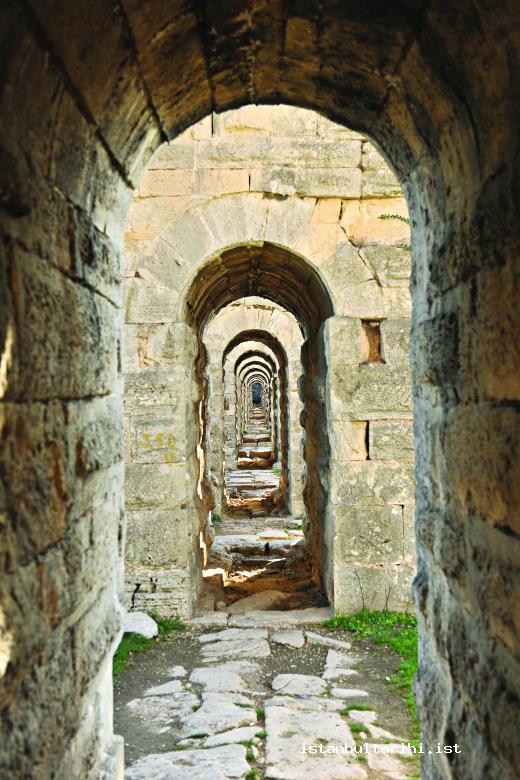
The water galleries that belonged to the facilities were built in such a way that allowed one person to walk throughout them. The width was 50–55 centimeters and the height was 1.75 meters. In order to be able to care for and repair these water galleries, inspection shafts measuring 30–40 meters were constructed along with the water distribution pipeline.
Halkalı Aqueducts
Mazul Aqueduct (Mazlumkemer) was the first aqueduct of Halkalı water. This 104-meter-long, 14-meter-high aqueduct was built by the Romans. After the conquest, while bringing water to the city, old water conduits were repaired and enlarged. Fatih water passed over this aqueduct and was converted to Beylik water with additions made and repairs done during the reign of Mahmud I. Moreover, the clay pipes of the Süleymaniye water conduits also passed over this aqueduct. Today, it is in the Atışalanı (Avasköy) region.112
It is a strong plausibility that the gallery that passed through Mazul Aqueduct may have also passed through Bozdoğan Aqueduct and both of them may have been built at the same time. The water brought by this aqueduct drained into the Nifeum Maximum Cistern under the back square of the central building of Istanbul University. The aqueduct was effectively repaired and hundreds of fountains were fed by it.113
It is claimed that Bozdoğan Aqueduct unfolded with its majestic form in Saraçhane and was built by Hadrianus (117–38) and was restored by Valence (364–78). Although in the time of Herakleios (640–41) the aqueduct was destroyed, it was re-built by his successor Konstantinos V (741–75).
Taksim Aqueducts
Taksim water had two aqueducts. The first was a twenty-division, 150-meter-long, 3.5-meter-high, 2-meter-wide, medium-scale aqueduct. This aqueduct was called Bahçeköyü Aqueduct and it carried the water of the Topuzlu Reservoir, which was in the vicinity of Bahçeköyü and which was between Büyükdere and Bahçeköyü.114
The second one was the great and magnificent aqueduct called Büyükdere Aqueduct or Büyükkemer.115 This aqueduct was built along with Topuzlu and Valide reservoirs in 1732 during the reign of Mahmud I. This great aqueduct was also called Sultan Mahmud Aqueduct and was 400 meters long, 11 meters high, 3 meters wide, and had twenty one divisions.116
The water from these aqueducts met and was carried by various conduits, additions to the water system, and the aqueduct in Bahçeköy. It reached the aqueduct on the upper side of Büyükdere. Following the aqueduct, the water was carried through conduits encircling the bottom of the mountains. It sent the water in the direction of Yeniköy in Acıelma valley, Sultantepesi Mansion in Sultantepesi, and one branch each for Mehmed vineyard, Khedive Ismail Pasha Mansion, and Emirgan.
When the water route reached Maslak, the water of Boyacıköy, Ayaz Ağa Mansion, and Rumelihisarı was supplied, Yatakbaşı conduit water was provided, and from there to the vicinity of the nearby Levent Farm water was distributed through the Arnavutköy service. It passed through Hasan Ağa Aqueduct and reached Sultan Aqueduct in Zincirlikuyu. Here, providing the water of Kuruçeşme service for Zincirlikuyu Pavilion and passing through a conduit, one branch for each Yıldız and Çırağan palaces branched off. Again, there it left off the main course in the branch that went to Ortaköy. The course perpetually went through conduits, distributed water in Teşvikiye service in Pangaltı to the French Hospital in Şişli, and distributed water a down in the vicinity of Tatavla. It provided one branch for each for Beşiktaş (Dolmabahçe) Palace nearby the Military School and quarters in the vicinity and then reached the dome in the Military School. Providing the water of the school there, it passed through the water gauge in the Armenian cemetery in lead-iron alloy pipes before it finally reached the Taksim water chamber. From this chamber, one branch traveled toward Tophane and Kabataş, two toward Galata and Kasımpaşa, and one toward the Naval Arsenal (Tersane).117
Because of their mutual proximity, water from three Bahçeköy reservoirs that supplied Taksim was brought together into a single system. However, as the Kırkçeşme reservoirs near Belgrade village stood in three lines parallel to each other, water from these reservoirs reached quite far distances before they united with other water in Başhavuz. They had undulate courses and passed over a variety of aqueducts.118
Reservoirs
There was no need to hold the Halkalı water in a reservoir since this spring water was brought through pipes directly to the city. But the water of Kırkçeşme and, later, Taksim did need reservoirs.119 Instead of the term “reservoir,” sometimes the word “junction” is used.
Kırkçeşme Reservoirs
When the Kırkçeşme facilities were completed in the year 1563, the current reservoirs did not exist. There was only one reservoir or junction. In the Kırkçeşme facilities there were 570 additions.120
In order to constitute the supplementary water chambers four reservoirs were built at the mouth of the branches in order to store water when it was abundant and release it during summertime. They were Topuz Reservoir, Büyükbend, Ayvad Reservoir, and Kirazlıbend. These reservoirs were in the vicinity of an old Belgrade village, in the Belgrade Forest, and in the vicinity of Bahçeköy.121
During the reign of Ahmed III, seven reservoirs were built. Five of them were in the vicinity of Cebeci village, on Fatih (Mehmed II) Stream, one of them was near Belgrade village, on Topuzlu Stream (Topuzderesi), and another one was built by Sultan Osman II in the vicinity of Çiftehavuzlar. Apart from them, the previous reservoirs and courses were cleaned. Again, in the reign of Ahmed III, measures were taken to prevent the water of the reservoirs from being polluted by the neighboring villagers.
The region of reservoirs was in the Belgrade Forest. These forests are twenty kilometers away from Istanbul and are ten kilometers away from Büyükdere. The periphery is approximately thirty six kilometers and the field is 14,000 hectares. Within this forest, a total of seven reservoirs were built, four of which supplied water for Istanbul and three of which supplied water for Pera. Süleyman I settled the Bulgarians who showed usefulness in the Belgrade siege in Petra village, which remained from the Byzantine time in the forest. The name of the village became Belgrade. Due to the cholera epidemic that happened in Istanbul, the village was found unfavorable and was evacuated.122
Topuz Reservoir
Topuz Reservoir, which was the oldest and was built by Osman II in 1620, was a small reservoir. It was also called Karanlıkbend, Kömürcü Reservoir, and Osman II Reservoir. It is within Belgrade Forest, half an hour to the northwest of Belgrade village. It was built on Topuzlu Stream (Paşa Stream) which is a branch of Kağıthane Stream.
It collects primarily from Topuzlu Stream, in addition to other streams and flood waters. It was built during the repair of the Kırkçeşme water conduits that were destroyed in a flood disaster in 1619. The water of this reservoir passes Kömürcü Stream, collects additional water and reaches Büyükbend. The water basin of the reservoir is 4,562,000 square meters and the tonnage is 62,612 cubic meters.123
Though the water basin of the reservoir is small, the streams which constitute their resources bring abundant water. In heavy rainfall they are filled in eight hours, and even in its dry season five meters of water is obtained from the streams which suffices to supply it for twenty days. This reservoir does not have a specific course. As it was in the location of the supplementary store of Büyükbend,124 which was situated to the lower side, the water of Topuz Reservoir drains into the water basin of Büyükbend and was known by the name of Belgrade Stream.
While one would expect there to be a water inlet grate and a sediment tank at the entry of the Kırkçeşme reservoirs, there are not. It was thought that such devices had been in place prior to the building of Büyükbend in 1724, but that later on there was no need for these facilities as water was drained into Büyükbend rather than into the water distribution pipeline. Develioğlu Aqueduct and Alacahamam Aqueduct—which were on the line that connected the end of the Paşa Reservoir part of Topuzludere (Paşa Stream), one of three branches of the water conduit—must have been built along with the Topuz Reservoir in 1620.
Büyükbend
This reservoir, which is known as the Great Reservoir (Bend-i Kebir) or Belgrade Reservoir, is in Belgrade Forest, half an hour to the southeast of Belgrade village. It is on the Belgrade Stream, which is one of the branches of Kağıthane Stream whose water comes from Topuz Reservoir.
It is thought that this reservoir dates from the Roman era (146 BC–AD 395) and was updated in the reign of Mehmed II in 1460–61. It was repaired in the reign of Sultan Süleyman I in 1563. The current reservoir was re-built by Ahmed III in 1724. Ahmed III wanted to construct a new reservoir within the facilities of Taksim water; however, the Patrona Halil Rebellion prevented it from being built.
Unlike other reservoirs, there was a two-division sediment tank also known as çiftehavuz (double pool) on the front side of the reservoir. Büyükbend water, whose rate of flow was very high, was filtered in two stages in this double pool and visible dirt such as sand and stones was removed.
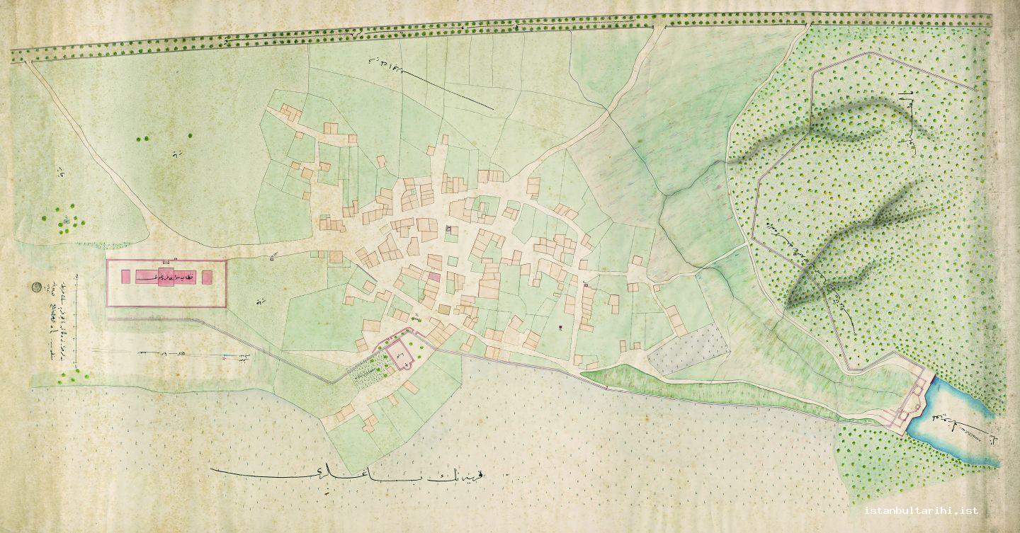
The reservoir was destroyed as a result of an accident and underwent significant repairs during the reign of Mahmud I in 1748. Its volume was increased to its current level by Abdulhamid II in 1900. The water basin is 6,920,000 square meters and its tonnage is 1,255,000 cubic meters.125
The water of this reservoir unites with the water of Kirazlibend, passes over Develioğlu, Alacahamam, Çaşnigir, Karakemer, and Eğrikemer (Burgaz Reservoir, Kovukkemer) and comes to Güzelce Woods. It passes through these woods with additions to the water system and it pours out into Başhavuz, which is one and a half hours away.126
Ayvad Reservoir
The Avyad Reservoir was built during the reign of Mustafa III in 1765–66 (AH 1179). It is within the Ayvad (Evhad, Avhadlu) Woods in Belgrade Forest and on Ayvad (Evhad) Stream, which is one of the branches of Kağıthane Stream.127
Its height is 13.45 meters, the length of the set is 700 meters, its water basin is 2,000,000 square meters and its water collecting capacity (tonnage) is 157,000 cubic meters.
After Ayvad Reservoir streams through twenty four pipes (lüle) into a river course (sandık) and flows down the river bed for around half an hour. Then, it goes through a grate and sands and into a gallery so as to unite with the Sultan Süleyman course which comes from Ortadere. Passing over Ayvad Aqueduct, it covers a twenty-minute distance through the gallery until it unites with the Bakracdere gallery which was again built by Süleyman I.
The waters of Bakraçdere, Ayvad Reservoir, and Ortadere pass over Kurd Aqueduct via a single course. They come together in the gallery of the Davud Pasha Course, pass over the stream between Petnahor and Burgaz villages via Uzunkemer Aqueduct, and then re-enter the gallery. Following a course around hillsides, Güzelce Woods, and foothills again, they unite with other water in Başhavuz.
The water united likewise passes through a conduit, passes over Mavlova and Güzelce aqueducts and goes to Genoese conduit near Cebeci village, which receives the main conduit built by Süleyman I. It comes to the grate before Cebeci Stream and, passing through the conduit, it forms a single course before Güzelce Aqueduct. From here, through conduits and by way of minor aqueducts, it passes via Çavuş village over Ağılıdere and Uzunkoltuk streams. It passes over Çiftekemer and Balıklı aqueducts and comes to the grate in Küçükköy. From there it flows over Keçe and Sineklikemer aqueducts and arrives at the Yenikubbe division in Eyüp. Until it comes to the division, the water of the supplemental water networks near its route mixes with the water of this reservoir.
The water is separated for the Eyüp service zone from Yenikubbe and is separated for the Zal Pasha and Ayvansaray service units through the conduit between the Yenikubbe and Eğrikapı divisions. What is left behind from this source goes to the Eğrikapı division. The water coming from this division goes to the Yedikule and Yukarıana service zones. The total amount of water allocated and allowed to flow from the Eyüp-Yenikubbe division to the Great Hagia Sophia division is 1610 masuras (one-quarter of a lüle), or 201.5 lüles.
Ayvad Reservoir was badly damaged in the 1894 earthquake. Therefore, its reservoirs, reservoir courses, and water conduits were repaired, with the exception of the Köprül and Ebussuud water conduits. Later, water conduits were not repaired and even minor repairs were neglected. Therefore, the majority of these water conduits fell out of use. Because the water conduits and hundreds of additions to the water network included in the courses were eventually ceased to function, reservoir water itself fell out of use.128
Kirazlıbent
The last reservoir of the network is Kirazlıbend (Sultan Mahmud Reservoir), built by Mahmud II within Belgrade Forest in 1818 (or in 1837–38 [AH 1253]). It was built in the woods on Kirazlıdere stream which was one of the branches of Kağıthane Stream. It is half an hour east of Büyükbend and mixes with the water of Büyükbend. It is one of the most elegant reservoirs.
The water of Kirazlıbend, whose yield was quite high, poured into the 200-meter down grate (sudde) and then poured into the pool called “sandy place,” where it was cleared of sediment and joined its course. Passing over Kirazlıkemer, which was built in 1818 along with Kirazlıbend, it again united with Büyükbend which was fifteen minutes away.129
The height is 11.25 meters, the length is 640 meters, and the water collection capacity (tonnage) is 150,000 cubic meters. This capacity today has decreased to 104,000 cubic meters.
The water of all Kırkçeşme reservoirs in the vicinity of Belgrade village is always collected in Başhavuz.
Taksim Reservoirs (Bahçeköy Reservoirs)
Bahçeköy reservoirs collect Taksim water and are on Acıelma Stream which originates in Belgrade Forest on the side near the shore to the east of Kağıthane valley. The Acıelma valley unites with Büyükdere valley near Bahçeköy. Also, on each side of Kağıthane valley there were reservoirs and grates.130
After the water of three reservoirs in Bahçeköyü joins, it passes over the land side of Bahçeköyü through an underground conduit. After collecting supplemental water from the additions to the water network, it passes over the aqueduct in the village and re-enters the conduit. It arrives at a location called Fıstık, and then it surfaces at Büyükkemer in Buyukdere.
The reservoirs within this network were: the Bahçeköyü Aqueduct between Büyükdere and Bahçeköyü, the Topuzlu Reservoir (Mahmud I Reservoir) built by Mahmud I in the year 1750 on Eskibağlar Streamlet which joins the Acıelma branch of Kağıthane Stream, the Valide Reservoir built by Mihrişah Sultana (the mother of Selim III) on the east branch of Arabacı Mandıra Stream which joins the Acıelma branch of Kağıthane Stream, and the Sultan Mahmud aqueduct-reservoir (Bend-i Cedid, Mahmud II Reservoir) built on the west branch of Arabacı Mandıra Stream by Mahmud II in the year of 1839. Some of these reservoirs were cleaned in 1832.131
The water collected by the Belgrade village reservoirs which supplied Kırkçeşme water and the Bahçeköy reservoirs that supplied the Taksim water to the Pera and Rumeli sides of the Bosporus followed separate courses after they left the reservoirs. The course of Kırkçeşme water stands to the west of Kağıthane Stream and the course of Taksim water stands to the east of it.
As the course of Taksim water, which stands to the east of Kağıthane Stream and which comes from the Bahçeköy reservoirs, was almost completely underground, it ran a flat course. Over the Taksim course there are three major aqueducts. One of them is Sultan Mahmud I Aqueduct at Büyükdere and the other two are small aqueducts near Pera.
Though the Taksim water course is quite flat, Kırkçeşme water has a somewhat winding course. One of the reasons for the convolutions along the course was the joining of additions to the water network at the middle and end of the course. Another reason was that the reservoirs which provide Kırkçeşme water are not on a line with one another.
The reservoirs of Taksim water are on the branches of Acıelma Stream, which joins the Kağıthane Stream. These reservoirs and the course which drains their water are completely Ottoman works. Byzantine emperors diverted water only to Istanbul and water could not be diverted to quarters such as Kasimpasha, Pera, Galata, Tophane, Fındıklı, Dolmabahçe, Beşiktaş, and other quarters inhabited in the Byzantine era. However, in the reign of Mahmud I, in order to bring water to the region, two reservoirs in Bahçeköy and the courses in Buyukkemer and Buyukdere were built. Then Mahmud II added another reservoir, bringing the total number of Taksim (Bahçeköy) reservoirs to three.132
One of the important components of the quality of the Taksim water conduit network is Topuzlu Reservoir. This was one of the two reservoirs built in 1750 during the reign of Mahmud I.
Topuzlu reservoir stands ten minutes to the northeast of the village of Bahçeköy. It was constructed over Eskibaglar Streamlet which joins the Acıelma branch of Kağıthane Stream. In fact, this reservoir was built in 1731–32 (AH 1144), but was modified and elevated by Cezayirli Hasan Pasha to carry water to the fountains in Kasımpaşa which he built as charity. It is a 66 meters long.133 Its water basin is 920,000 square meters, and its tonnage is 156,700 cubic meters. The water of this reservoir flows through an underground conduit and unites with the water of the other two reservoirs.134
There is another reservoir in the Acıelma valley somewhat south of Büyükkemer Aqueduct on which construction began during the reign of Abdülaziz (1861–76), but which was never completed.
Although there are such claims that the Valide Reservoir was built by Sabiha Sultana, mother of the Mahmud I, it was actually built on behalf of Mihrişah Sultana, mother of Selim III, in 1796–97 (AH 1211).135
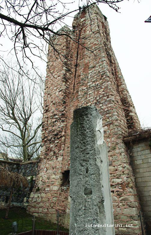
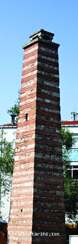
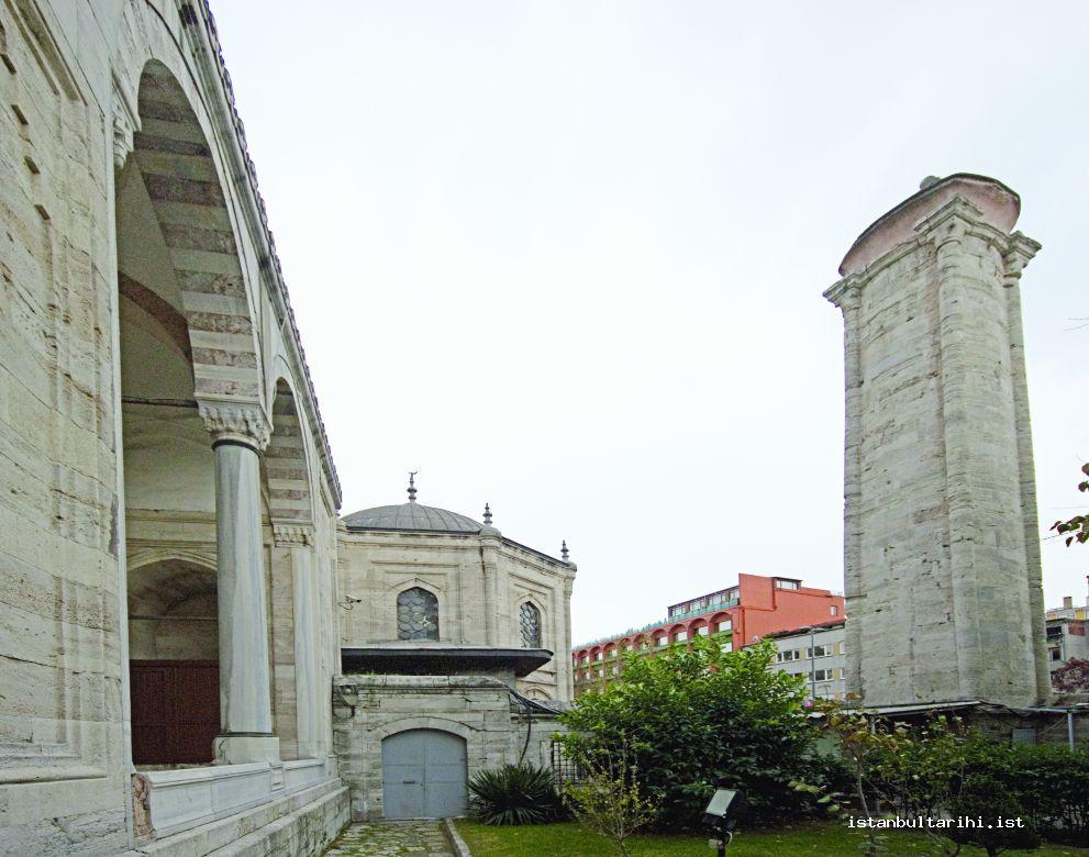
The construction of the reservoir was completed on 24 January 1797 and it was built in such a way that it could also contribute to the Kırkçeşme network by means of a canal pouring into Karanlıkbend when its water source was abundant. The total rate of flow of this reservoir was twenty three lüles, eighteen lüles of which joined Taksim water. The remaining five lüles were left to the the waqf of Mihrişah Sultana to be distributed in accordance with her will.
It was built on the eastern branch of Arabacı Mandırası Stream, which joins the Acıelma branch of Kağıthane Stream to the northwest of Bahçeköyü. In fact, while it was thought to feed the charity in Eyüp, later it supported Pera network. The length of this set reservoir is 70 meters. Its water basin is 92,000 square meters and tonnage is 200,000 cubic meters.
After the Valide addition to the water network near the Valide Reservoir joins the main stream, it flows through underground conduits and unites with the Bend-i Cedid water. Again, it goes underground through pipes around the hillside and unites with the course originating from Topuzlu Reservoir.
At times this reservoir was called the Bend-i Cedid (New Reservoir).136 This reservoir, though it was allocated to Pera later, continued its activity on the route of Kırkçeşme water and it supplied water to the Eminönü-Kumkapı region.137 Therefore, Taksim reservoirs supported Kırkçeşme Water conduits at the same time.
Valide Reservoir is accepted as one of the majestic examples of aqua-architecture.138
The genuine Bend-i Cedid was built during the reign of Mahmud II in 1839. It is in northeastern Bahçeköyü and on the western branch of Arabacı Mandırası Stream.139
The water basin of the reservoir is 130,000 square meters and its tonnage is 243,000 cubic meters. The water enriched by the additions to the water network passes over aqueducts and merges with water of the Valide Reservoir.140
The routes of the water of the Belgrade village reservoirs, which supply Kırkçeşme water of Istanbul and the water course of Bahçeköy reservoirs, are different. The course of Kırkçeşme water is to the west of Kağıthane Stream, and the course of Taksim water runs to its east. However, though these water conduits followed separate routes, they still contributed to each other.141
POOLS, GRATES AND SHAFTS
Apart from the reservoirs and aqueducts, there were ponds called havuz (pool) and water grates. These ponds on the water conduits were called “sand-pits” (kumluk) by water conduit caretakers. They were where water was collected. The major ones were Başhavuz (Sultan Osman), Çiftehavuz, and Balıklıhavuz on Bakrac Stream and Ortadere. The most important one was Başhavuz in the vicinity of Burgazköyü. Ayvad, Valide, Kirazlı, Kurt Aqueduct, Paşa Stream, Ayvad Stream, Bakrac Stream, and Ortadere pools were on the route of Kırkçeşme water. Balıklıhavuz was not for filtering water but was built to collect spring water cleanly for which reason it was not located on the course of the water conduit.142 Çeşmehavuz in the vicinity of Küçükkoy could be added to this list as well.143
The Romans collected water from springs and streams in cisterns and brought it to the city through water conduits and aqueducts. It is understood from the pond which was called “Başhavuz” near Burgazköyü that the Byzantines also used this method. This Başhavuz was not a reservoir, but a great man-made pool. In contrast, a reservoir (bent) was a different sort of construction designed to collect water in a basin.
After the water of every branch had been filtered in their separate pools, it all went into this great pool, was cleaned for the last time, and then flowed into Istanbul where it went to water collection and distribution centers.144
In the term of water conduit officials, there were facilities called grates (ıskara/ızgara). Grates stood at the head of streams to filter water. These were sets constructed in specific locations of streams to collect water and send it to one of the main water routes.145
In some documents ıskara was used in this sense.146
The circumference of the tunnels and galleries which constituted the course of Kırkçeşme water was so large that a man could walk through it. Vertical shafts at intervals of thirty to forty meters were placed along the course. The conduit servicemen entered the tunnels through these shafts.
Apart from these, in the houses located on these underground water conduits, water was obtained from the course by opening haphazard shafts and wells towards the end of this period.147 There were more than one hundred open shafts from Yenikubbe in Eyüp up to the Hagia Sophia water collection and distribution center on the main Kırkçeşme conduit and there were more than fifty open chimneys on the branch from the Eğrikapı division to Yedikule. These shafts were inappropriate for sanitary reasons.148
WATER DISTRIBUTION TO WATER OWNERS AND CHARITIES
Water distribution to the city was calculated by measurement units including “hilal” (crescent), “çuvaldız” (packing needle), “masura” (spout), “kamış” (reed), and “lüle” (pipe) , and by way of centers called “kubbe” (dome), “savak” (sluiceway), “maksem” (water collection and distribution center) or “taksim” (division-distribution). The Eğrikapı sluiceway149 and Galata-Pera water collection and distribution center were the most well-known ones. The water brought through canals and aqueducts (kanavat u musennat) from the north of the historical peninsula of Istanbul was distributed by way of service units inside the city. However, since Üsküdar water, just like Halkalı and Hamidiye water that fed the old walled city of Istanbul and Pera-Galata, was waqf spring water, it was conveyed by underground pipes.
Domes (Kubbe) and Water Collection and Distribution Centers (Maksem)
The water distribution centers which distributed water to buildings in measures such as masura and lüle were called kubbe (dome), taksim (division), maksem (water collection and distribution center), or savak (sluiceway). Some of these significant facilities were within the city, such as Kırkçeşme Dome in Hagia Sophia,150 and some of them were on water conduit routes, such as Valide Dome.151
There were rooms or buildings used for distributing water which came from one or several branches to various courses. They were of all sizes and numbered seven or eight in total. The most important ones were Eğrikapı maksem, Taksim-Pera maksem, Tophane maksem, and Yenikubbe in the Islambey quarter of Eyüp.
After the Kırkçeşme sewage pipeline passed over Güzelcekemer and twenty three large and small aqueducts, it first stopped in Yenikubbe, and then it stopped in Eğrikapı water collection and distribution center, which was the main distribution dome.152 This was also called Eğrikapı sluiceway. The Eğrikapı maksem was the last stage of the Kırkçeşme water system and from that point on water was distributed to Istanbul. Water conduits also reached other water collection and distribution centers. Among them were Hagia Sophia division (taksim) and division point (taksim maslağı).
Galata-Pera maksem, which is located at one of the corners of Taksim Square in Pera, gave its name to the quarter of Taksim.153
The maksem of Şerefabad Mansion was one of the more magnificent Üsküdar maksems, and a fine example in its own right of eighteenth-century architecture. It was on the road from Doğancılar to Imrahor. This structure with a dome was made of a row of thick marble and two rows of bricks. Around it, there was Doğancılar Mosque, Hacı Ahmed Paşa Tomb and Palace, Hacı Ahmed Paşa Bath, and other historical places.
It was built to supply and organize the water of Şerefabad Mansion by the head architect of the Tulip Age, Kayserili Mehmed Ağa, in 1728–29 (AH 1141). This maksem also met the water need of some other public fountains in Üsküdar. Water collection and distribution centers are also called “divisions” (taksim).
Water Gauges
Water gauges were important in the distribution stage. These were small pressure control towers which work in accordance with the principle of combined vessels. They were in the shape of a frustum-pyramid and measured and distributed water. Water gauges were built to prevent the explosion of clay pipes due to the excessive pressure which could occur in some regions of the water distribution network. They existed in the Halkalı and Üsküdar water conduits.
The spouts (lüle) over them were used for measuring out and distributing water to various places. Since Kırkçeşme water was surface water, there was no need for water gauges in the main gallery. However, there were water gauges over clay pipes that stemmed from the main gallery. Among many water gauges available in the main city network, one can mention Yenikapı, Çatladıkapı, Hagia Sophia, and Tahtakale.
There were a plenty of underground conduits and water gauges built on Halkalı water which generally came through clay pipes, both in the water distribution pipeline and in the city distribution network.154 Especially along the water conduits such as Nur-i Osmaniye that passed through rough land, there were many water gauges and thereby pressure on the clay pipes was lowered.155 It is possible to determine the route of water conduits by following water gauges.156
There are some water gauges within the city that can be seen today and whose names were given to the street on which they are located. Some were main water gauges and had names such as Ferruh Kethüda, Hoca Manolaki, Havzlı Hamam Terazisi (the water gauge of the bath with a pool), and Ragıb Paşa.
Water wheels are wheels used for raising water to high points. They are useful for raising water from streams to aqueducts.
Clay Pipes and Conduits
Water and water conduits reached the city through clay pipes and usually lead pipes through an underground conduit network called “lağım” (gallery) and “kanavat.”157 The documents mention potters and clay pipe artisans (künkçü) as well as the Kirazlıkatma pipeline in this regard.158
Clay pipes could not withstand much pressure. Therefore, water gauges were built along the route that prevented them from exploding under excessive pressure. These specific water gauges were available in only certain regions of the network.
There were different kinds of clay pipes used in former times. The principal ones were seven-finger pipes, six-finger pipes, pasha pipes, old one-finger pipes, and Albanian pipes. Here finger-width (parmak) measurements were used to gauge the caliber, with twenty four parmaks to an arşın, or Turkish yard.
Clay pipes and lead pipes were generally used on Halkalı and Üsküdar water conduits. These included six-finger pipes, and were also used on the Kırkçeşme water route.
The domestic lead pipes formerly used in water conduits were unlike the lead pipes imported from Europe. Master craftsmen produced them by curving sheet lead. They luted these telescopic pipes. Later, lead pipes resistant to pressure were imported from Europe. These were called Frenk borusu, or “French pipe.”159
Underground Conduits
Water conduits reached the city through an underground canal network called lağım and kanavat. There were two main water conduits, the Süleymaniye160 and Genoese conduits.161 The former was the water conduit built by Süleyman I in 1525 and enriched by great aqueducts and works. This was the section running six hours in several branches from Ayvad and Belgrade to Güzelcekemer aqueduct near Cebeci village. The Genoese conduit, which was the older section, was the old conduit that carried water to Istanbul from Cebeci village.162
Some of the conduits where water was collected were main conduits. The conduit of Kırkçeşme water and Hagia Sophia Waqf were important. Many additions were built and were attached to these.
Water Cells
The cells built at certain points of the course branches of water conduits were called “meslek” or in conventional speech “maslak.” These cells were used to determine water amounts. They allowed workers to check blockages and to repair facilities easily. A number of districts today take their name from these cells, including as Maslak, Kızılmaslak, and Acımusluk.
Maslaks in the Haslar region of the Kırkçeşme network, such as Başhavuz, Ibrahim Khan Water, and Vekil-i Harç (majordomo), and Mahmed Agha water are mentioned in historical documents. Again, in the historical peninsula of Istanbul, the central maslak as well as the maslaks of Arpaemini Mehmed Efendi Fountain waqf water, Kabasakal, Kemeraltı, Kırkçeşme, Orta Yatakbaşı, and Patrikhane (patriarchate) are noted in the documents.
Cisterns and Water Chambers
Many of the facilities which brought water to the city were destroyed during the sieges Istanbul faced in the past. From the end of the Roman era onward, beginning in the fourth century, a plethora of open and closed cisterns were built to supply water to the city and to resist the sieges.
Open cisterns filled with soil in time. Today there are çukurbostans (garden pits) where these open cisterns once lay.
There are over seventy closed cisterns in the historical peninsula of Istanbul is. The greatest of the closed cisterns is the 336-column Basilica Cistern (Yerebatan) built in the reign of Byzantine Emperor Justinian I (527–65). A number of other cisterns are also worthy of note, including the 224-column Filoksene (binbirdirek) in Hagia Sophia built during the reign of Constantine I, Aetius (Vefa-Karagümrük Stadium) built by Theodosius II (408–50), the Theodosian Cistern near the current Eminönü municipality building in Çemberlitaş, Aspan (Çukurbostan, Sultanselim), Hagios Makios (Altınkemer), and Acımusluk.163
Since the outer canals were destroyed by those who besieged the city, these facilities were replaced by closed cisterns built within the city. Out of all these, only the Cistern Philoxenos and Basilica Cistern survive today.164 Today these are used as museums. Most of the cisterns are on the borders of the Fatih municipality.
Cisterns were used to meet the city’s water needs before the conquest. Hence, during the substructure and tunnel excavation of the Maviray Project, cisterns were found on the road to Koşuyolu Ibrahimağa convent (zaviye) and were thought to belong to Byzantine-era architecture.
Only a few of the Byzantine closed cisterns kept water. The needs of nearby houses were met through drilling the tops of the vaults of the great Basilica Cistern. According to the great traveler Evliya Çelebi, in the seventeenth century water was still available in the Pantokrator Abbey Cistern in Zeyrek, which was used by the houses over the cistern. Moreover, Piri Paşa Masjid was therefore called Soğukkuyu Masjid.165
Before the conquest, the water needs of Galata were also met by cisterns. One of them was near the Saint Benoit Church. It is very likely that under the Arab Mosque there is also a cistern. In Taksim, down from the German Hospital, the remnants of a cistern structure were found.166
It is understood that some of the open and closed cisterns were used by the Ottomans.167 Especially the open cisterns were used as vegetable gardens and called çukurbostan. Ottomans used some aqueducts from water facilities left over from the Roman and Byzantine eras within the water distribution pipeline.
Nazım Bey provides a list which mentions the width, length, and height of old cisterns.168
In various places of the city, water houses which were called water chambers (tanks) were built as small-scale cisterns. Among these, Pera, specifically the Taksim tank, was a great twenty-four room water house that was used as the great water tank of Pera, Kasımpaşa, and Tophane.169
The Spring Head Signs and Wells
The value attached to water resulted in the utilization of springs and even the quality of ordinary well water on behalf of the state. Moreover, some interesting signs that were important for aqua-architecture were placed at the spring heads. In the western part of the city, there are some spring stones over which there are epitaphs in rough land, resembling a tombstone. They are interesting in terms of showing the extent of the water network in Istanbul and reflecting the value that was attached to it. These are at the source of the springs that charitable people connected as additions to the water supply network to feed the charity fountains. One of the oldest of this kind of spring marker stone is that of Sinan Pasha, the conqueror of Yemen, erected in Sağmalcılar.170 It is known that waqf wells were also opened within the city, in nearby quarters and in wasteland in the past.171
FOOTNOTES
1 Masura corresponds to 6.5 m3 or 6.5 tons of water per day.
2 There are many provisions on this topic. For details, see Ahmet Tabakoğlu et. al. Vakıf Su Defterleri: Kırkçeşme Suları, İstanbul 1999, vol. 1, 13-1/2b/1, 2 and Ahmet Tabakoğlu et al. İstanbul Şer‘iyye Sicilleri: Mâ-i Lezîz Defterleri, Istanbul 2000, v. 6, 331/3/1.
3 By Ahmet Tabakoğlu et al., Vakıf Su Defterleri: Hatt-ı Hümâyûn, İstanbul 1997, 1/121/1: Fî evâsıt-ı Safer (1) 138/ October 19-28, 1725.
4 Kırkçeşme Suları, v. 2, 14-1/134b/1: Fî 17 Cemaziyelevvel (1)256/17 July 1840.
5 Ahmet Tabakoğlu et al. (prep.), Vakıf Su Defterleri: Suyolcu, İstanbul 2002, v. 2, s. 4, 11/39/2: Fî 31 Kânunuevvel (1)296/12 January 1881.
6 Mâ-i Lezîz, v. 10, pp. 42, 412/17/2: Fî gurrei Cemaziyelahir 1242/31 December 1826; v. 10, 412/20/2: Fî gurrei Cemaziyelahir 1242/31 December 1826.
7 Ahmet Tabakoğlu et al. (prep.), Vakıf Su Defterleri: İlmühaber, İstanbul 1999, v. 4, 18/79/1; 18/81/1: Fî 21 Kânûnusâni (1)320/3 February 1905.
8 Ahmet Tabakoğlu et al. (prep.), Vakıf Su Defterleri: Avrupa Yakası Suları, İstanbul 2002, v. 2, 8/436/1: 1182/18 May 1768-6 May 1769.
9 Kırkçeşme Suları, v. 1, 13-1/140a/1.
10 O. Nuri Ergin, “Vesâit-i İtfâiyeden İstanbul Suları”, Vakıf Su Tahlilleri XIX ve XX. Yüzyıllarda İstanbul Suları, prep. Ahmet Tabakoğlu et al., İstanbul 2000, v. 1, pp. 135-137; Gâlib Ata, “İstanbul Evkâf Suları”, Vakıf Su Tahlilleri XIX ve XX. Yüzyıllarda İstanbul Suları, prep. Ahmet Tabakoğlu et al, İstanbul 2000, v 1, pp. 154-155; Kazım Çeçen, İstanbul’un Osmanlı Dönemi Suyolları, prep. Celal Kolay, İstanbul 1999, p. 26.
11 Ahmet Tabakoğlu et. al. (prep.), Vakıf Su Defterleri: Halkalı Suları, İstanbul 2001, c. 1, 24/42/1: Fî 11 Şaban 1304/5 May 1887 ve fî 23 April (1)302/5 May 1886.
12 Nâzım Bey, “İstanbul Vilayeti Şehremâneti’ne Evkâf’dan Devr Olunan Sular”, Vakıf Su Tahlilleri XIX ve XX. Yüzyıllarda İstanbul Suları, prep. Ahmet Tabakoğlu et al., İstanbul 2000, v. 1, p. 178.
13 Ahmet Kal’a et al. (prep.), İstanbul Ahkâm Defterleri: İstanbul Vakıf Tarihi, İstanbul 1998, v. 1, p. 410; the relevant official staff must have obtained extra income for this duty. See. Ali Berktay (trans.), Albertus Bobovius ya da Santuri Ali Ufki Bey’in Anıları: Topkapı Sarayı’nda Yaşam, İstanbul 2002, pp. 27, 28.
14 R. Mantran, 17. Yüzyılın İkinci Yarısında İstanbul, trans. M. Ali Kılıçbay ve E. Özcan, Ankara 2001, v. 2, p. 218.
15 Nâzım, “İstanbul Vilayeti Şehremâneti’ne Evkâf’dan Devr Olunan Sular”, v. 1, p. 177. The documents also offer details on reservoir guards in the reservoirs, such as in Belgrade and Bagchekoyi.
16 Nazif Öztürk, “Osmânlı Su Vakıfları”, Osmanlı Su Medeniyeti: Uluslararası Sempozyum, 5-8 Mayıs, 2000: Bildiriler, İstanbul 2000, p. 102.
17 İlmühaber, vol. 4, pp. 276, 18/124/2.
18 Halkalı Suları, vol. 1, 24/41/2.
19 Suyolcu, vol. 1, 11/1/1.
20 Halkalı Suları, v. 1, 24/41/2; Ergin, “Vesâit-i İtfâiyeden İstanbul Suları”, v. 1, p. 128.
21 Suyolcu, v. 1, 11/1/1.
22 Suyolcu, v. 1, 10/143/3: Fî 23 Şaban 1320/24 November 1902; v. 1, 10/143/6: 3 Cemaziyelevvel 1328/13 May 1910; Fî 10 Rebiülahir 1328/20 April 1910; v. 1, 10/1516/1.
23 Ergin, “Vesâit-i İtfâiyeden İstanbul Suları”, v. 1, p. 128.
24 Halkalı Suları, v. 1, 24/42/1: Fî 11 Şaban 1304/5 May 1887; fî 23 April (1)302/5 May 1886.
25 Mâ-i Lezîz, v. 7, 367/: Fî 23 Zilhicce 1231/16 November 1816; v. 8, 375/10/1: Fî 26 Zilhicce 1232/6 November 1817; v. 8, 367/87/2: Fî 29 Receb 1232/14 June 1817; c. 8, 367/88/1: 29 Receb 1232/14 June 1817; c. 8, 367/88/2: Fî 29 Recebülferd 1232/14 June 1817; c. 8, 367/89/1: Fî 29 Receb 1232/14 June 1817; v. 8, 367/89/2: Fî 15 Şaban 1232/30 June 1817; v. 8, 367/90/1: Fî 18 Şaban 1232/3 July 1817; v. 8, 367/90/2: Fî 25 Şaban 1232/10 July 1817; v. 8, 367/91/1: Fî 27 Şaban 1232/12 July 1817; v. 8, 367/92/1: Fî 29 Şaban 1232/14 July 1817.
26 Mâ-i Lezîz, v. 8, 367/93/1: Fî 19 Zilkade 1232/30 September 1817.
27 Mâ-i Lezîz, v. 11, 439/34/2: Fî gurre-i Receb 1250/3 November 1834.
28 Gâlib Ata, “İstanbul Evkâf Suları”, v. 1, p. 146.
29 Ergin, “Vesâit-i İtfâiyeden İstanbul Suları” v. 1, p. 140.
30 One of these maps was published by Süheyl Ünver. Later, Kâzım Çeçen created great works about the main water conduits of the city and introduced both water conduits and those places which benefitted from them.
31 Halkalı Suları, v. 1, 24/42/1: Fî 23 April (1)302/5 May 1886; fî 11 Şaban 1304/5 May 1887.
32 Suyolcu, v 1, 10/143/3: Fî 23 Şaban 1320/24 November 1902; v. 1, 10/143/6: 3 Cemaziyelevvel 1328/13 May 1910; Fî 10 Rebiülahir 1328/20 April 1910; v. 1, 10/1516/1.
33 Bkz. Gâlib Ata, “İstanbul Evkâf Suları”, v. 1, p. 151; Çeçen, İstanbul’un Osmanlı Dönemi Suyolları, pp. 24-25. Also see Nâzım, “İstanbul Vilayeti Şehremâneti’ne Evkâf’dan Devr Olunan Sular”, v. 1, pp. 170, 190.
34 Nâzım, “İstanbul Vilayeti Şehremâneti’ne Evkâf’dan Devr Olunan Sular”, v. 1, p. 190.
35 Nâzım, “İstanbul Vilayeti Şehremâneti’ne Evkâf’dan Devr Olunan Sular”, v. 1, p. 191.
36 Semavi Eyice, “İstanbul (Tarihî Eserler)”, İA, V/2, pp. 1214/85-86.
37 Ergin, “Vesâit-i İtfâiyeden İstanbul Suları”, v. 1, pp. 132, 137.
38 Bkz. Halkalı Suları,, v. 1, pp. 6, 24/2/1; plus see. Çeçen, İstanbul’un Osmanlı Dönemi Suyolları, p. 100.
39 Nâzım, “İstanbul Vilayeti Şehremâneti’ne Evkâf’dan Devr Olunan Sular”, v. 1, pp. 171-172; Gâlib Ata, “İstanbul Evkâf Suları”, v. 1, pp. 153-155; Ergin, “Vesâit-i İtfâiyeden İstanbul Suları”, v. 1, pp. 134-137.
40 Ergin “Vesâit-i İtfâiyeden İstanbul Suları”, v. 1, pp. 135-137; Gâlib Ata, “İstanbul Evkâf Suları”, v. 1, pp. 154-155; Çeçen, İstanbul’un Osmanlı Dönemi Suyolları, p. 26.
41 Çeçen, İstanbul’un Osmanlı Dönemi Suyolları, pp. 180-184; Kazım Çeçen, İstanbul’un Vakıf Sularından Halkalı Suları, İstanbul 1991; Kazım Çeçen, II. Bayezid Suyolu Haritaları, İstanbul 1997.
42 Nâzım, “İstanbul Vilayeti Şehremâneti’ne Evkâf’dan Devr Olunan Sular”, v. 1, p. 176.
43 Ekrem Hakkı Ayverdi, Fâtih Devri Mi‘mârîsi, İstanbul 1953, p. 42; Şehabeddin Tekindağ, “İstanbul”, İA, V/2, pp. 1208-1213; Eyice, “İstanbul”, V/2, pp. 1214/57, 85-86, 109, 154; Çeçen, İstanbul’un Vakıf Sularından Taksim ve Hamîdiye Suları, İstanbul 1992, pp. 35-166: Çeçen, II. Bayezid Suyolu Haritaları, p. 46; Çeçen, İstanbul’un Osmanlı Dönemi Suyolları, pp. 25-32, 251; Mehmet Bildirici, “İstanbul Beyoğlu Yakası Tarihi Çeşmeler ve Onları Besleyen Su Kaynakları”, Osmanlı Su Medeniyeti: Uluslararası Sempozyum, 05-08 Mayıs 2000: Bildiriler, İstanbul 2000; Mehmet Bildirici, “Galata Eski Su Yolları” (June 2000), www.mehmetbildirici.com.
44 Eyice, “İstanbul”, V/2, pp. 1214/86-88.
45 Tekindağ, “İstanbul”, V/2, p. 1213.
46 On this topic, see Eyice, “İstanbul”, V/2, pp. 1214/88; Kazım Çeçen, Mimar Sinân ve Kırkçeşme Tesisleri, İstanbul 1988; Çeçen, İstanbul’un Osmanlı Dönemi Suyolları, pp. 24-25.
47 Nâzım, “İstanbul Vilayeti Şehremâneti’ne Evkâf’dan Devr Olunan Sular”, v. 1, p. 166; Gâlib Ata, “İstanbul Evkâf Suları”, v. 1, p. 148.
48 Ömer Lutfi Barkan, “Tarihî Demografi Araştırmaları ve Osmanlı Tarihi”, TM, 1954, v. 10, pp. 1-26; Halil İnalcık, The Ottoman Empire: The Classical Age: 1300-1600, London 1973, p. 141.
49 Halkalı Suları, v. 1, pp. 90-96, 24/173/1.
50 The income share of the 1547–48 budget was 198,887,294 silver Ottoman coins, while the expenditure share was 111,997,449 silver Ottoman coins. The income share of the 1565–66 budget was 183,088,000 silver Ottoman coins and the expenditure share was 189,657,000 silver Ottoman coins. See Ahmet Tabakoğlu, Toplu Makaleler, İstanbul 2005, v. 1, p. 188.
51 Çeçen, Mimar Sinân ve Kırkçeşme Tesisleri, p. 165.
52 Halkalı Suları, v. 1, 24/3/1: 29 August 1883.
53 İbrahim Edhem b. Said, “İstanbul Suyollarıyla Bendlerinin ve Mebânî-i Müteferria-i Sâiresinin Hulâsa-i Ahvâl-i Târihiye ve Hâzırası”, Vakıf Su Tahlilleri XIX ve XX. Yüzyıllarda İstanbul Suları, prep. Ahmet Tabakoğlu et al, Istanbul 2000, v. 1, pp. 46-47.
54 For the mosques and small mosques which used Kırkçeşme water, see Nâzım, “İstanbul Vilayeti Şehremâneti’ne Evkâf’dan Devr Olunan Sular”, v. 1, pp. 193-222.
55 Gâlib Ata, “İstanbul Evkâf Suları”, v. 1, p. 151.
56 Gâlib Ata, “İstanbul Evkâf Suları”, v. 1, pp. 144-146.
57 Eyice, “İstanbul”, V/2, pp. 1214/88.
58 Nâzım, “İstanbul Vilayeti Şehremâneti’ne Evkâf’dan Devr Olunan Sular”, v. 1, p. 170.
59 Nâzım, “İstanbul Vilayeti Şehremâneti’ne Evkâf’dan Devr Olunan Sular”, v. 1, pp. 191, 193-195, 197-202; Kırkçeşme Suları, v. 1-2.
60 On this issue, see Çeçen, Taksim ve Hamîdiye Suları, pp. 30, 35-166.
61 İbrahim Edhem, “İstanbul Suyollarıyla Bendlerinin ve Mebânî-i Müteferrika-i Sâiresinin Hulâsa-i Ahvâl-i Târihiye ve Hâzırası”, v. 1, p. 50.
62 On this topic see Naci Yüngül, Taksim Suyu Tesisleri, İstanbul 1957.
63 Gâlib Ata, “İstanbul Evkâf Suları”, v. 1, p. 145.
64 Eyice, “İstanbul”, V/2, pp. 1214/155.
65 Çeçen, İstanbul’un Osmanlı Dönemi Suyolları, pp. 315-316.
66 Gâlib Ata, “İstanbul Evkâf Suları”, v. 1, p. 146.
67 Nâzim, “İstanbul Vilayeti Şehremâneti’ne Evkâf’dan Devr Olunan Sular”, v. 1, pp. 212-222; Eyice, “İstanbul”, V/2, pp. 1214/153.
68 In the relevant document, it is emphasized that Üsküdar water is spring water like Halkalı water. See Halkalı Suları, v. 1, pp. 67, 24/41/1. This volume contains the first section of the number 24 volume and the first section of the number 15 volume. They include the period between the years 1873 and 1895 and they are in the archives of the Istanbul Water and Sewage Administration. Gâlib Ata, “İstanbul Evkâf Suları”, v. 1, p. l55.
69 About holy water of Greek Orthodoxs and springs see Ahmed Safi Bey, “İstanbul’un Menba’ Suları”, Vakıf Su Tahlilleri XIX ve XX. Yüzyıllarda İstanbul Suları, prep. Ahmet Tabakoğlu et al., İstanbul 2000, v. 1, p. 109.
70 Kazım Çeçen, İstanbul’un Vakıf Sularından Üsküdar Suları, İstanbul 1991, p. 24; Çeçen, İstanbul’un Osmanlı Dönemi Suyolları, pp. 197-237.
71 Çeçen, İstanbul’un Osmanlı Dönemi Suyolları, pp. 197-237.
72 Ergin, “Vesâit-i İtfâiyeden İstanbul Suları”, v. 1, p. 138.
73 Gâlib Ata, “İstanbul Evkâf Suları”, v. 1, p. 155.
74 Gâlib Ata, “İstanbul Evkâf Suları”, v. 1, p. 156.
75 Nâzım, “İstanbul Vilayeti Şehremâneti’ne Evkâf’dan Devr Olunan Sular”, v. 1, p. 181.
76 Ergin, “Vesâit-i İtfâiyeden İstanbul Suları”, v. 1, p. 137.
77 For example, see Çeçen, Üsküdar Suları, pp. 22, 26.
78 Cosimo Comidas de Carbognano, XVIII. Yüzyılın Sonunda İstanbul, trans. Erendiz Özbayoğlu, Istanbul 1993, p. 89; P. G. İnciciyan, XVIII. Yüzyılda İstanbul, trans. Hrand D. Andreasyan, Istanbul 1976, p. 134; Eremya Çelebi Kömürciyan, İstanbul Tarihi: XVII. Yüzyılda İstanbul, trans. H. D. Andreasyan, publisher K. Pamukciyan, Istanbul 1980, pp. 49, 279, 280; Sarkis Sarraf Hovhannesyan, Payitaht İstanbul’un Tarihçesi, trans. Elmon Hançer, Istanbul 1996, p. 38; Nâzım, “İstanbul Vilayeti Şehremâneti’ne Evkâf’dan Devr Olunan Sular”, v. 1, pp. 181-188; Gâlib Ata, “İstanbul Evkâf Suları”, v. 1, pp. 155-157; Ergin, “Vesâit-i İtfâiyeden İstanbul Suları”, v. 1, p. 137; Nirven, İstanbul Suları, pp. 222-225; Çeçen, Üsküdar Suları, pp. 36, 39-43, 48, 56-61, 68-75, 109-118; Çeçen, II. Bayezid Suyolu Haritaları, pp. 57-58; Eyice, “İstanbul”, V/2, pp. 1214/69; Tahsin Yazıcı, “Üsküdar”, İA, XIII, 129.
79 Nâzım, “İstanbul Vilayeti Şehremâneti’ne Evkâf’dan Devr Olunan Sular”, v. 1, p. 190.
80 Suyolcu, v. 1, 10/18/2-5, 10/60/1-2, 10/134/1-3, 10/135/1-3, 10/136/1-2, 10/137/1-7, 10/145/1-3, 10/151-3/4, 10/151-6/1; c. 2, 12-1/27a/1, 12-1/28b/3.
81 İlmühaber, v. 4, 18/47/2: Fî 5 Receb 1286/11 October 1869; Halkalı Suları, v 1, pp. 10, 24/2/1; Ahmet Tabakoğlu et al. (prep.), Vakıf Su Defterleri: Su Keşif Defteri, İstanbul 2003, v. 3, 27/82/1: Fî 2 Muharrem (12)93/29 January 1876; Suyolcu, v. 1, 10/145/3; Nâzım, “İstanbul Vilayeti Şehremâneti’ne Evkâf’dan Devr Olunan Sular”, v. 1, pp. 185, 187, 188, 216-218, 221, 222, 224; Gâlib Ata, “İstanbul Evkâf Suları”, v. 1, p. 157; Ergin, “Vesâit-i İtfâiyeden İstanbul Suları”, v. 1, p. 137.
82 Ergin, “Vesâit-i İtfâiyeden İstanbul Suları”, v. 1, p. 137; It is known that Istanbul Municipality repaired Kadıköy fountains: Nâzım, “İstanbul Vilayeti Şehremâneti’ne Evkâf’dan Devr Olunan Sular”, v. 1, p. 185.
83 Tuzla İçmeler water is imported. Nâzım, “İstanbul Vilayeti Şehremâneti’ne Evkâf’dan Devr Olunan Sular”, v. 1, p. 187.
84 On this topic see Çeçen, Taksim ve Hamîdiye Suları.
85 Eyice, “İstanbul”, V/2, pp. 1214/155.
86 Eyice, “İstanbul”, V/2, pp. 1214/88.
87 Ergin, “Vesâit-i İtfâiyeden İstanbul Suları”, v. 1, p. 137.
88 Eyice, “İstanbul”, V/2, pp. 1214/89; Veysel Eroğlu, “Tarih Boyunca İstanbul’a Su Veren Kaynaklar”, Osmanlı Su Medeniyeti: Uluslararası Sempozyum, 5-8 Mayıs 2000: Bildiriler, Istanbul 2000, p. 38.
89 For more detailed information see H. İbrahim Gül, “Terkos Su Şirketi”, doctoral dissertation, Marmara University, 2009; İlhami Yurdakul, Aziz Şehre Leziz Su: Dersaadet Su Şirketi (1873-1933), İstanbul 2010.
90 Tarih Boyunca İstanbul Suları ve İstanbul Su ve Kanalizasyon Sorunu, Istanbul 1983, p. 43.
91 Nirven, İstanbul Suları, p. 198; Burhan Oğuz, Bizans’tan Günümüze İstanbul Suları, Istanbul 1998, p. 89.
92 For the Regulations of the Istanbul Kizildere Water Company see İmtiyâzât ve Mukâvelât, İstanbul 1302, v. 1, pp. 654-676.
93 For the Regulations of the Dersaadet Water Company see İmtiyâzât ve Mukâvelât, v. 2, pp. 1114-1133.
94 İlhami Yurdakul (edit.), XIX. ve XX. Yüzyılda İstanbul Suları, İstanbul 2000, p. 22.
95 Yurdakul (edit.), XIX. ve XX. Yüzyılda İstanbul Suları, p. 22.
96 See Fethi İsfendiyaroğlu, “Terkos Sularının ve Kırkçeşme, Halkalı Çeşmelerinin Vaziyeti Nedir ve Ne Yapılmak İsteniyor?”, Vakıf Su Tahlilleri XIX ve XX. Yüzyıllarda İstanbul Suları, prep. Ahmet Tabakoğlu et al., İstanbul 2000, v. 1, p. 235.
97 Ergin, “Vesâit-i İtfâiyeden İstanbul Suları”, v. 1, p. 140.
98 Yurdakul (edit.), XIX. ve XX. Yüzyılda İstanbul Suları, pp. 23-24.
99 See the contract for the Üsküdar and Kadıköy Water company privileges. For the appendix to regulations about water distribution, see Düstur, İkinci tertip, İstanbul 1334, v. 6, pp. 877, 878, 879-885; Yurdakul (edit.), XIX. ve XX. Yüzyılda İstanbul Suları, p. 24.
100 Yurdakul (edit.), XIX. ve XX. Yüzyılda İstanbul Suları, p. 23.
101 İlmühaber, v. 2, 5/100/1: Fî 20 Şaban 1227/29 August 1812; Fî gurre-i Zilkade 1230/5 October 1815.
102 Kırkçeşme Suları, v. 1, 13-1/93b/1: 15 Rebiülevvel 1260/4 April 1844.
103 Kırkçeşme Suları, v. 1, 13-1/115a/1: gurrei Rebiülevvel 1268/25 December 1851.
104 BOA, Mühimme Defteri, 2/276/728, Zeyl; 19/135/286: Fî 9 Safer 980/21 June 1572; 47/12/30; 55/90/158; 73/240/559: Yevmü’l-ahad fî 18 Ramazân sene selâse; Suyolcu, v. 1, 11/15/1: Fî evâili Safer 1277/1928 August 1860.
105 Tekindağ, “İstanbul”, V/2, p. 1213; Eyice, “İstanbul”, V/2, pp. 1214/85-103.
106 Kırkçeşme Suları, v. 1, 13-1/56a/2: gurrei Cemaziyelevvel 1266/15 March 1850.
107 Eyice, “İstanbul”, V/2, s. 87; Çeçen, İstanbul’un Osmanlı Dönemi Suyolları, pp. 70-86; Kazım Çeçen, “XVI.yüzyılda Osmanlı İmparatorluğunda Yapılan Su Tesisleri”, Osmanlı İmparatorluğu’nun Doruğu, 16. yüzyıl Teknolojisi, ed. Kazım Çeçen, İstanbul 1999, pp. 40-41.
108 Çeçen, İstanbul’un Osmanlı Dönemi Suyolları, p. 31; Kömürciyan, İstanbul Tarihi, p. 175
109 Çeçen, İstanbul’un Osmanlı Dönemi Suyolları, pp. 31-32; Kömürciyan, İstanbul Tarihi, p. 175.
110 Gâlib Ata, “İstanbul Evkâf Suları”, v. 1, p. 151.
111 Gâlib Ata, “İstanbul Evkâf Suları”, v. 1, p. 151; Çeçen, İstanbul’un Osmanlı Dönemi Suyolları, pp. 33-36.
112 Çeçen, Halkalı Suları; Çeçen, İstanbul’un Osmanlı Dönemi Suyolları, p. 29.
113 Çeçen, Hamîdiye Suları, p. 86.
114 Eyice, “İstanbul”, V/2, pp. 1214/88; Çeçen, Hamîdiye Suları, p. 86.
115 İbrahim Edhem, “İstanbul Suyollarıyla Bendleri”, v. 1, p. 49.
116 Çeçen, İstanbul’un Osmanlı Dönemi Suyolları, p. 30.
117 Gâlib Ata, “İstanbul Evkâf Suları”, v. 1, pp. 146-152; Ergin, “Vesâit-i İtfâiyeden İstanbul Suları”, v. 1, p. 132.
118 Gâlib Ata, “İstanbul Evkâf Suları”, v. 1, p. 151.
119 Eyice, “İstanbul”, V/2, p. 1214/87.
120 Çeçen, İstanbul’un Osmanlı Dönemi Suyolları, p. 68.
121 Çeçen, İstanbul’un Osmanlı Dönemi Suyolları, pp. 68, 86-100.
122 Nâzım, “İstanbul Vilayeti Şehremâneti’ne Evkâf’dan Devr Olunan Sular”, v. 1, p. 166; Gâlib Ata, “İstanbul Evkâf Suları”, v. 1, p. 148; Eyice, “İstanbul”, V/2, pp. 1214/88.
123 Gâlib Ata, “İstanbul Evkâf Suları”, v. 1, p. 149; Nâzım, “İstanbul Vilayeti Şehremâneti’ne Evkâf’dan Devr Olunan Sular”, v. 1, p. 166.
124 İbrahim Edhem, “İstanbul Suyollarıyla Bendleri”, v. 1, pp. 46-47.
125 Nâzım, “İstanbul Vilayeti Şehremâneti’ne Evkâf’dan Devr Olunan Sular”, v. 1, p. 166.
126 İbrahim Edhem, “İstanbul Suyollarıyla Bendleri”, v. 1, pp. 46-47; Gâlib Ata, “İstanbul Evkâf Suları”, v. 1, p. 149; Nâzım, “İstanbul Vilayeti Şehremâneti’ne Evkâf’dan Devr Olunan Sular”, v. 1, p. 166.
127 Gâlib Ata, “İstanbul Evkâf Suları”, v. 1, pp. 149-150; Eyice, “İstanbul”, V/2, p. 1214/88.
128 Nâzım, “İstanbul Vilayeti Şehremâneti’ne Evkâf’dan Devr Olunan Sular”, v. 1, p. 166.
129 İbrahim Edhem, “İstanbul Suyollarıyla Bendleri”, v. 1, pp. 46-47; Nâzım, “İstanbul Vilayeti Şehremâneti’ne Evkâf’dan Devr Olunan Sular”, v. 1, p. 166; Gâlib Ata, “İstanbul Evkâf Suları”, v. 1, p. 150; Eyice, “İstanbul”, V/2, pp. 1214/88.
130 On this topic see Çeçen, Taksim ve Hamîdiye Suları, pp. 45-61.
131 Çeçen, İstanbul’un Osmanlı Dönemi Suyolları, pp. 251-253.
132 Gâlib Ata, “İstanbul Evkâf Suları”, v. 1, p. 150; Çeçen, Taksim ve Hamîdiye Suları, pp. 30, 254-263.
133 Eyice, “İstanbul”, V/2, pp. 1214/88.
134 İbrahim Edhem, “İstanbul Suyollarıyla Bendleri”, v. 1, p. 44.
135 Çeçen, İstanbul’un Osmanlı Dönemi Suyolları, pp. 251-253.
136 Kırkçeşme Suları, v. 1, 13-1/27b/1: gurrei Cemaziyelevvel 1259/30 May 1843; 21 Ramadan 1287/15 December 1870.
137 Kırkçeşme Suları, v. 2, 14-1/190b/2: 11 Zilhicce 1255/16 January 1840; v. 2, 14-1/194b/2: 18 Receb 1247/23 December 1831.
138 Eyice, “İstanbul”, V/2, pp. 1214/88.
139 Eyice, “İstanbul”, V/2, pp. 1214/88; Çeçen, İstanbul’un Osmanlı Dönemi
Suyolları, pp. 254-263.
140 Gâlib Ata, “İstanbul Evkâf Suları”, v. 1, p. 150.
141 Gâlib Ata, “İstanbul Evkâf Suları”, v. 1, p. 150.
142 İbrahim Edhem, “İstanbul Suyollarıyla Bendleri”, v. 1, pp. 44-45.
143 Kırkçeşme Suları, v. 1, 13-1/114b/1: 23 Cemaziyelahir 1266/6 May 1850.
144 Kırkçeşme Suları, c. 1, 13-1/15a/1: 3 Cemaziyelevvel 1207/17 December 1792; c. 1, 13-1/64b/1: 5 Zilhicce 1253/31 Ocak 1838; c. 1, 13-1/51b/1: 7 Zilhicce 1256/1 January 1841; c. 1, 13-1/15a/2: 9 Ramadan 1259/4 October 1843; 2, 14-1/237a/2: 19 Rebiülahir 1262/16 April 1846; 2, 14-1/2191Aa/2: gurrei Muharrem 1266/17 November 1849.
145 İbrahim Edhem, “İstanbul Suyollarıyla Bendleri”, v. 1, p. 47.
146 Mâ-i Lezîz, v. 6, 331/48/1; İbrahim Edhem, “İstanbul Suyollarıyla Bendleri”, v. 1, p. 47.
147 Halkalı Suları, v. 1, 24/42/1: Fî 11 Şaban 1304/5 May 1887; fî 23 April (1)302/5 May 1886.
148 Gâlib Ata, “İstanbul Evkâf Suları”, v. 1, p. 152; water conduit servants could only enter with their boots: p. 160.
149 The Eğrikapı water collection and distribution center is called a division. It is the work of Süleyman I. It is the main water distribution center within the historical peninsula of Istanbul. See İnciciyan, XVIII. Yüzyılda İstanbul, p. 26; Kırkçeşme Suları, v. 1, 13-1/55a/2: 14 Rebiülahir 1261/22 April 1845.
150 Kırkçeşme Suları, v. 1, 13-1/114a/1: gurrei Cemaziyelevvel 1264/6 April 1848; v. 2, 14-1/156a/1: 17 Cemaziyelahir 1261/23 June 1845; c. 2, 14-1/231b/3: 26 Safer 1273/27 October 1856.
151 Kırkçeşme Suları, v. 2, 14-1/2191Aa/2: gurrei Muharrem 1266/17 November 1849.
152 İbrahim Edhem, “İstanbul Suyollarıyla Bendleri”, v. 1, p. 47.
153 Eyice, “İstanbul”, V/2, pp. 1214/89.
154 Ergin, “Vesâit-i İtfâiyeden İstanbul Suları”, v. 1, p. 135; Because water gauges were not known in Europe, and despite the interest they aroused in European writers who wrote works about Istanbul, no Europeans understood the purpose of these water gaugesd until Tchihatchef’s work (Pierre de Tchihatchef, İstanbul ve Boğaziçi trans. Ali Berktay, Istanbul 2000, pp. 26-27). These were seen on Halkalı and Üsküdar water conduits: Gâlib Ata, “İstanbul Evkâf Suları”, v. 1, p. 153.
155 Çeçen, İstanbul’un Osmanlı Dönemi Suyolları, pp. 100, 187.
156 On this point, see Tchihatchef, İstanbul ve Boğaziçi, pp. 26-27.
157 Kırkçeşme Suları, v. 1, 13-1/37b/2: 28 Rebiülahir 1235/10 June 1907; v. 2, 14-1/209a/1: 19 Muharrem 1249/8 June 1833.
158 Su Keşif Defteri, v. 2, 27/68/1; v. 2, 27/69/1; v. 3, 27/31/1.
159 Gâlib Ata, “İstanbul Evkâf Suları”, v. 1, p. 153; Ergin, “Vesâit-i İtfâiyeden İstanbul Suları”, v. 1, p. 135; Çeçen, İstanbul’un Osmanlı Dönemi Suyolları, p. 123.
160 Kırkçeşme Suları, v. 2, 14-1/236a/1: 17 Şaban 1258/23 September 1842.
161 Kırkçeşme Suları, v. 1, 13-1/13-4a/1: 9 Şaban 1275/15 March 1859.
162 Kırkçeşme Suları, v. 1, 13-1/13-4a/1: 9 Şaban 1275/15 March 1859; v. 1, 13-1/55a/2: 14 Rebiülahir 1261/22 April 1845; v. 2, 14-1/236a/1: 17 Şaban 1258/23 September 1842; İbrahim Edhem,“İstanbul Suyollarıyla Bendleri”, v. 1, p. 47.
163 About cisterns see Petrus Gyllius, İstanbul’un Tarihi Eserleri, trans. Erendiz Özbayoğlu, Istanbul 1997, p. 22, 143; Kömürciyan, İstanbul Tarihi, p. 175; İnciciyan, XVIII. Yüzyılda İstanbul, pp. 72-74; A. Decei, “İstanbul”, İA, V/2, s. 1151; Çeçen, İstanbul’un Osmanlı Dönemi Suyolları, pp. 23-27; Semavi Eyice, Eski İstanbul’dan Notlar, İstanbul 2006, pp. 34-38.
164 Halil İnalcık, “İstanbul”, DİA, XXIII, 244.
165 İnalcık, “İstanbul”, XXIII, 244.
166 Eyice, “İstanbul”, V/2, pp. 1214/155.
167 Kırkçeşme Suları, v. 1, 13-1/135a/2: 17 Cemaziyelahir 1260/4 July 1844; date registry 25 Rebiülevvel 1291/12 May 1874; v. 2, 14-1/239a/1: 26 Cemaziyelahir 1265/19 May 1849.
168 Nâzım, “İstanbul Vilayeti Şehremâneti’ne Evkâf’dan Devr Olunan Sular”, v. 1, p. 223.
169 Kırkçeşme Suları, v. 1, 13-1/64b/1: 25 Receb 1271/13 April 1855; v. 2, 14-1/155b/2: 13 April 1321/26 April 1905; v. 2, 14-1/240b/2: 18 Şevval 1266/27 August 1850.
170 Sadi Nazım Nirven, “Eski Su Tesislerinde Menbâ Başlarına Konan Nişan Taşları”, Arkitekt, 1962, v 32, p. 307, v. 77 et al.
171 “İstanbul”, DİA, XXIII, 255.