It is possible to list the number of characteristics that distinguish Istanbul from other cities. However, none of these can be compared to the feature of a city that spans two continents. In this regard, no other city in the world is like Istanbul. This distinguishing feature is geography’s gift to Istanbul. In the same way that the topographical features blended into Istanbul’s historical silhouette, the city’s geographical features merged with other attributes to create a magnificent city.
Istanbul, which acted as capital to three important empires, for quite some time consisted of the area within the city walls. This area is known as suriçi, the Historical Peninsula or original Istanbul. According to Kuban, the total land mass of this area is 1.440 hectares, and according to Darkot and Tuncel, 1.700 hectares.1
The spatial development of Istanbul is partially a reflection of the increase in industrialization and the migration that occurred in this city; this is due to the fact that the rapid urban development which was observed in Istanbul was closely affiliated with the industrialization that took place after 1950 and the large flow of migration that accompanied this process.
The land area of Istanbul, which underwent rapid growth, all the while under the control of factors that affect spatial development, expanded until it reached the current city limits. The city, initially established on the European continent, in time expanded into Asia. The Istanbul of today is a city that joins these two continents. The bridges built over the Bosphorus Straits are components that formalize this unification.
The most important stage in the spatial development of Istanbul, a city with a long historical past, was experienced in the 20th century. Even though there were historical residential areas outside the city walls at the beginning of the 20th century, such as Eyüp, Galata and Üsküdar, the largest expansion of the city across wide areas occurred during the post-1950 period. From this date on, migration to Istanbul and the resulting increase in population are some of the most important factors in the city’s spatial development.
Differing values are given for the size of the city. The city, which was 37 km2 during the Byzantine era, reached 139 km2 in 1923, 334 km2 in 1950, 910 km2 in 1970, 1.991 km2 in 1994 and 2.819 km2 in 2000.2 However, another study estimated the city’s size in 2007 at 1.017 km2.3 According to Kuban, the width of the area connected to the Municipality of Istanbul was 7.000 hectares in 1945 and 28.000 hectares in 1960, while the Istanbul of today covers an area larger than 200.000 hectares.4 According to Döker however, the size of the city was 33.777 hectares in 1975, 60.512 hectares in 1990, 71.332 hectares in 2000 and reached 89.977 hectares in 2010.5 According to the data found in the 1980 İstanbul Nazım İmar Planı (Istanbul Organized Developmental Plan), the city measured 66.230 hectares at the time. This area increased to 95.520 hectares in 1995. The settled area of Istanbul according to Ölçekli İstanbul Çevre Düzeni Planı (Scaled Istanbul Environmental Organization Plan), scaled at1/100.000 and published at the beginning of the 2000s, is 100.325 hectares.6 Even though different values are given in various sources regarding the city’s size, it can be understood that it underwent rapid growth after 1950. Subsequently to this date, as was the case in many areas, the city entered a period of rapid urban growth.
Naturally, the land on which Istanbul was built and the geographical features of its immediate environment had an impact on the city’s urban development. The physical attributes of the area played a guiding role in the establishment of the city and its physical development. Istanbul was established on a peninsula lying from east to west, with the Golden Horne to the north, the Bosphorus to the east and the Marmara Sea to the south. Because of this, the city grew spatially in keeping with the shape of this peninsula. On the other hand, areas suitable for settlement, transportation routes, industrialization, residential areas, administrative structure changes, and populations also acted as determining factors in the city’s spatial development.
Istanbul was the capital of the Ottoman state until its collapse in the 20th century. Having handed over its administrative function to the newly established capital of Ankara, Istanbul continued to maintain its position as the most important city in the country, in a number of aspects, including history, culture, economy and society.
The political and social events that were experienced in Turkey after 1950 had a significant impact on the urban development of the city. Turkey’s opening to the world and the adoption of a liberal economic structure increased Istanbul’s role as the country’s most important industrial and trade center; as a result, a large number of people immigrated to the city. With the immigration waves, which began in 1950, Istanbul experienced a rapid rise in population and this constantly increasing population, in turn, became the main impetus behind Istanbul’s urban growth.
As the most important industrial center in the country, and with an increase in the number of industrial facilities after 1950, these facilities began to be distributed within the city as well as in its immediate vicinity; such developments had an important effect on influencing urban development. The influence of industry on urban development was not limited to merely industrial facilities. The housing needs of industrial workers often prompted the emergence of gecekondus (shantytowns). As a result, industry directly influenced the emergence of new residential areas and was one of the most important factors shaping urban growth. As was the case in Zeytinburnu, Istanbul’s first gecekondu, residential areas were formed in this way, around industrial facilities. The Golden Horn, Gaziosmanpaşa, Eyüp, Alibeyköy and Kâğıthane are other examples of such developments. The addition of new industrial facilities to those already existing along the Golden Horn and the Bosphorus, as well as the opening of new industrial areas in the Kâğıthane Valley, Levent, Ayazağa, İstinye, Paşabahçe, Beykoz and Büyükdere, and the opportunity for existing industrial establishments to expand their facilities led to the rapid establishment of settlements in these areas.7 Industries established in the districts of Çubuklu, Paşabahçe and Beykoz attracted an influx of workers to these regions, and after 1950 gecekondu settlements in these districts developed their own unique character. The issue emerged of actual settlement on lands located close to these industrial areas, which were still owned by the treasury, various foundations (charities) and the municipality as in the cases of Zeytinburnu, Taşlıtarla, Kuştepe, Gültepe and Çeliktepe. These districts are gecekondu residential areas formed by immigrants who came to Istanbul after 1950. The number of gecekondus in Istanbul reached 120.000 in 1973.8
One of the important factors that also shaped Istanbul’s urban development was travel routes. From the beginning of the 21st century, transportation was influential, particularly railways. However, the situation changed after the 1950s: the new highways, which were opened to traffic between Istanbul-Ankara and Istanbul-Edirne, became the major factors that influenced the east-west development of Istanbul: the city developed linearly along these routes. The leading and determining effect of highway transportation on the urban development of Istanbul reached its peak with the opening of the Bosphorus (1973) and Fatih Sultan Mehmet (1988) bridges. While the highways that extended from the bridges ensured that Istanbul developed in an east-west direction, they were also the leading cause in the expansion of the city northwards. In particular, Fatih Sultan Mehmet Bridge, together with its connecting roads, had a tremendous influence on the city’s spread northwards. A similar development will be experienced with the third bridge, the construction of which began in May 2013, and with its connecting roads. Due to the compelling power of transportation over all sorts of human endeavors and activities, transportation routes and their immediate surroundings are quickly surrounded by industrial facilities and residential areas, resulting in the city’s expansion.
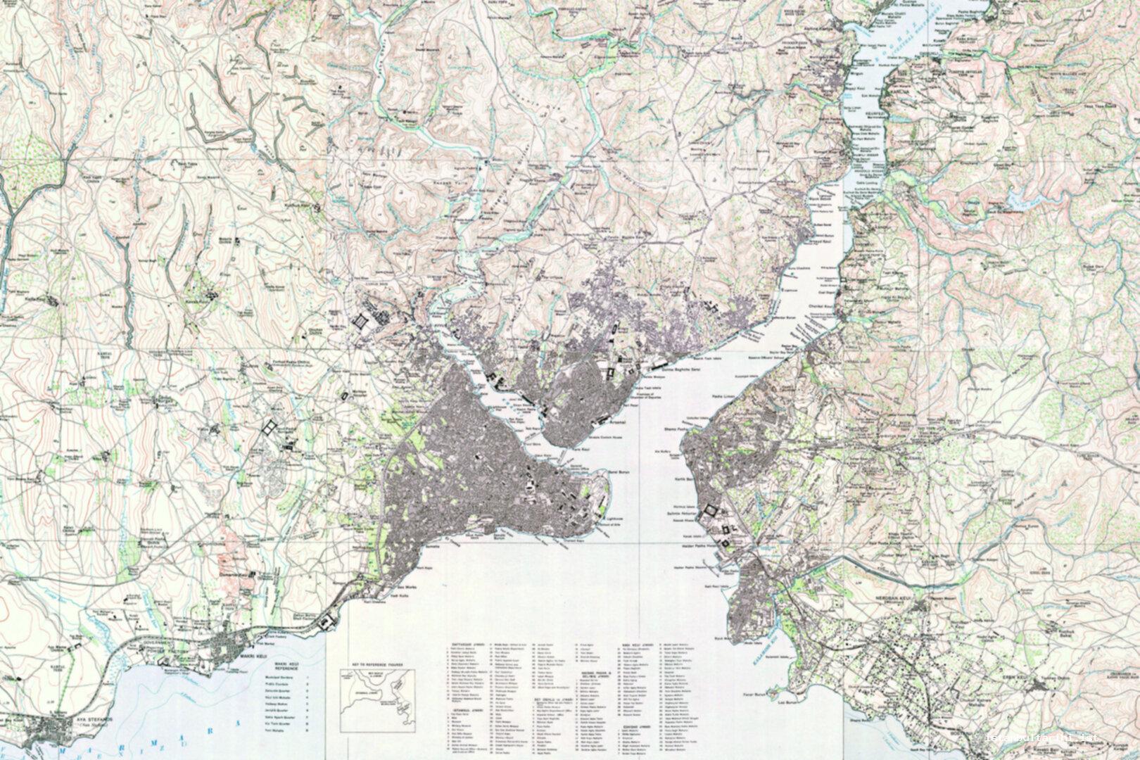
Istanbul in the 1920s
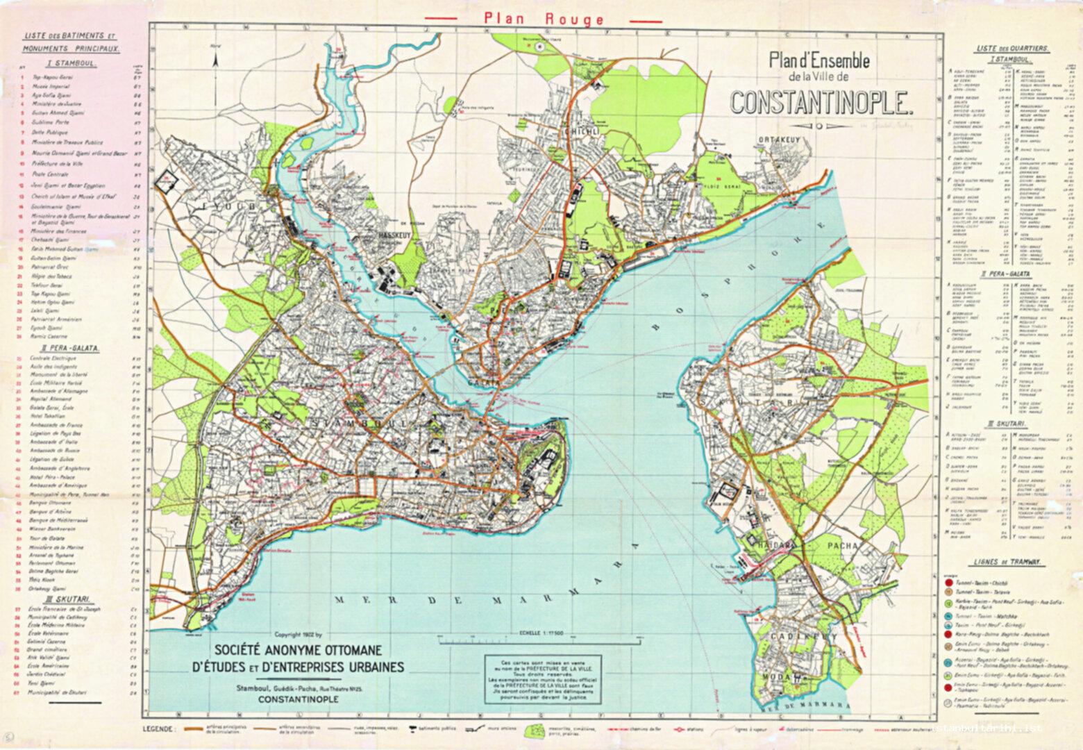
At the beginning of the 20th century, Istanbul spanned quite a small area of land, especially when compared to the area it covers today. In 1920, shortly before the declaration of the Republic, the city of Istanbul lay, for the most part, within the city walls that surrounded the historical peninsula.9 This area is generally known as the Historical Peninsula or suriçi. In this period, Eyüp, Galata, Üsküdar and Kadiköy were residential areas outside the suriçi. (Figure 1)
At the time, all of the area comprising suriçi consisted of residential areas. However, even though the area was not extensive, some areas had no settlements. Parts of Bayrampaşa Valley (also known as Yenibahçe) that were close to the walls, where Vatan Avenue passes today, and the Yenikapı area, where the valley opens up onto the sea, were some of the few areas with no settlements. Because of the cultivation of gardens and vineyards located in the valley close to the walls, this became known as Bayrampaşa Orchard or Yenibahçe. Today, Vatan Avenue passes through this area. In the area of Yenikapi that was not settled, the famous Langa Orchards could also be found. Moreover, the area around Topkapı, along with the areas close to the walls between Silivrikapı and Yedikule, were also not settled. However, the total area of these regions was not extensive. Apart from them, almost all of the Historical Peninsula was residential.10
In the 1920s, the historical city walls acted as the western border to the city. The most important residential area outside the city walls in this period was Eyüp. Even though it had a dispersed settlement structure, it was connected to suriçi Istanbul via Eyüp, Ayvansaray and Defterdar. Eyüp, which occupies an important place in the history of the city as well as in its social and cultural life, is one of the most important residential areas outside suriçi. However, Eyüp had a dispersed settlement structure in this period, with a small total settlement area. The settled area was limited to the areas around Eyüp Mosque and those surrounding Feshane. The Nişanca Mahalle to the west of Feshane and the Rami Yeni and Rami Cuma mahalles to the east of Rami Barracks were other settled areas.
The part of the city known as Galata consists of Sütlüce, Hasköy, Kasımpaşa, Beyoğlu, Taksim, Kurtuluş, Feriköy, Şişli, Beşiktaş and the areas around Ortaköy. Hasköy and the Okmeydanı slopes behind Hasköy and Kasımpaşa, were not densely populated residential areas at this time. The only building that was remarkable in Okmeydanı was the alms-house.
In the Galata area, the city extended up until where Şişli Mosque is located today; at the time the mosque had not yet been constructed. To the north was Mecidiyeköy, which had not yet become one with the city. The residential areas in Beşiktaş and Ortaköy were not expansive; Beşiktaş only extended up until Ihlamur Summer Palace and Yildiz Palace to the north. Balmumcu was a farm some distance from Beşiktaş and Ortaköy. Even more to the north was Zincirlikapu Farm, located where the Zircirlikuyu Cemetery is today.
In the 1920s the two residential areas outside the suriçi to the west of the city were Bakırköy and Yeşilköy. Both were residential areas that extended between the coast and the railway. In this period, the residential area of Bakirköy consisted of the area where the Zeytinlik and Cevizlik mahalles are located today.
In the 1920s, many farms and villages existed to the west of Istanbul, outside the suriçi. These have become important districts in the city today such as the areas of Osmaniye, Esenler, Güngören, Bağcılar (Çiftburgaz), Kalfaköy (Mahmutbey), Kocasinan and Yenibosna, as well as İncirli, Haznedar, Siyavuşpaşa and Metris farms.
In the 1920s, Arnavutköy, Büyük Bebek, Rumelihisarı, Boyacıköy, Yeniköy, Büyükdere and Sarıyer were small settlements along the Bosphorus coastline. The city only went as far as Ortaköy along the Bosphorus coast and the aforementioned districts were not part of the city.
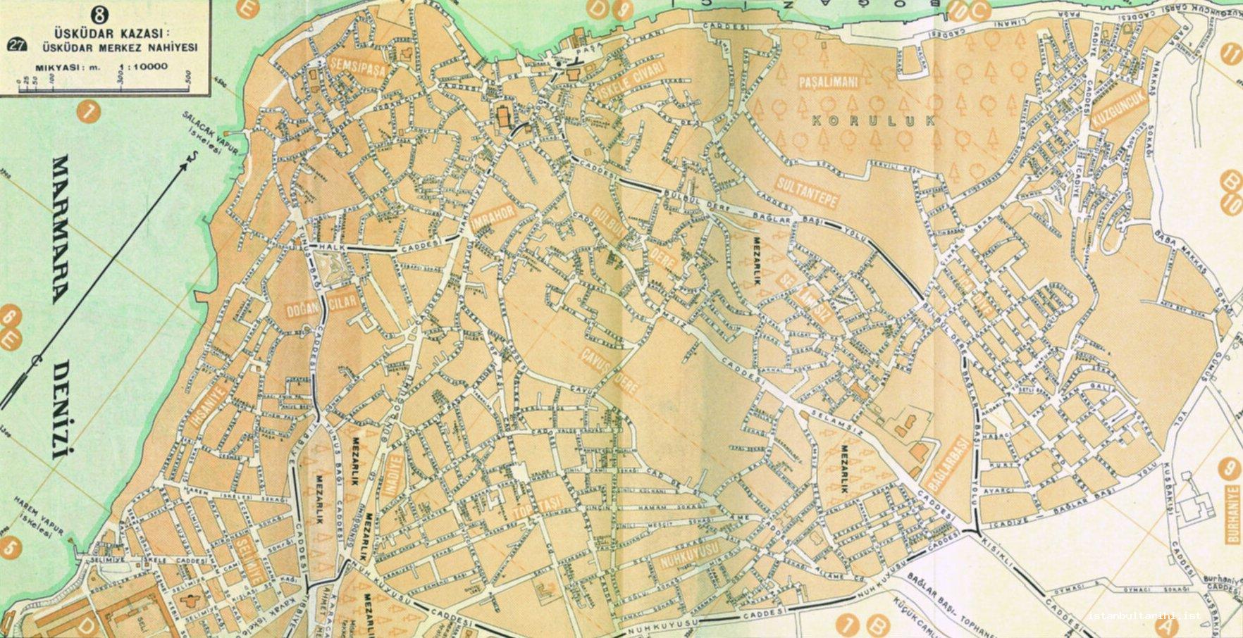
Istanbul’s original residential area on the Anatolian side was Üsküdar. In the 1920s the northern residential area of Üsküdar began at Kuzguncuk, but became quite scattered around the Paşalimanı area, and continued as far as the Selimiye Barracks to the south. The eastern border of Üsküdar extended until Bağlarbaşı and Nuhkuyusu Avenue. Altunizade, Validebağı and Koşuyolu were to the east of this line and thus sparse residential areas; they were districts that were not yet connected to the city. Kısıklı, Bulgurlu and Yeniköy (Muhacirköy),11 located further to the east, were other settlements located outside the city. The Karacaahmet Cemetery, located to the southeast of Üsküdar, was also outside of the city. Kadiköy and Üsküdar were not adjacent at this time. They were separated from one another by areas that were utilized for different purposes, such as Karacaahmet Cemetery, Selimiye Barracks, Haydarpaşa Numune Hospital and Haydarpaşa Station.
The second important area of settlement on the Anatolian side was Kadıköy. The basic residential area of Kadiköy extended from Haydarpaşa Station in the north to Hasanpaşa Gasworks and Kurbağalı Creek to the east; following this creek, the eastern border extended up to the Kalamış Inlet, passing through Yoğurtçu Meadow.12 Thus, Kurbağalı Creek constituted the eastern border of Kadiköy. Kadiköy, within these borders, consisted of Rasimpaşa, Hasanpaşa, Osmanağa and Caferağa mahalles. Moreover, the mahalles of İbrahimağa and Acıbadem, to the north, were newly forming, and the settlements here were quite scattered and scarce.
Even though there were residential areas to the east of Kurbağalı Creek, they were quite scattered. Settlement in this area took place more along the railway tracks. Kızıltoprak, Feneryolu, Göztepe, Erenköy, Suadiye and the Bostancı station were areas that had relatively more dense settlements. Other residential areas in the region north of the railway tracks were Merdivenköy, Sahrayıcedit and Erenköy.13
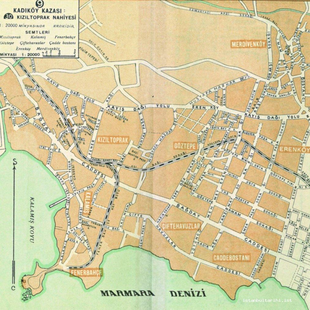
The railway line, which in the 1920s extended south of Feneryolu Station, continued up until Fenerbahçe; Fenerbahçe Station was located at the end of this route.14 This route exists in the city plan dated 1934.15 However, in the city plan dated 1955, it is seen that a street named Fenerbahçe Hatboyu existed on this route. This line roughly follows the street that is known today as Dr. Faruk Ayanoğlu Avenue. 16
To the north of Üsküdar, which was a single residential area along the Bosphorus coastline, stretching from Selimiye to Kuzguncuk, were Beylerbeyi, Çengelköy, Vaniköy, Kandilli, Anadoluhisarı, Kanlıca, Çubuklu, Paşabahçe and Beykoz; these were all small regions in the 1920s, lined up along the Anatolian coast of the Bosphorus.
Many of the city’s important districts today that are located on the Anatolian side of Istanbul were nothing more than farms and villages in the 1920s. Examples include Kavacık, Hekimbaşı, Hasibpaşa, Şerif Ali Çiftliği and Dudullu, Çekmeköy, Küçükbakkalköy, Büyükbakkalköy and Başıbüyük.
Istanbul in the 1930s
As far as the urban development discussed above, Istanbul in the 1930s was not that different from Istanbul in the 1920s. Between 1918 and 1922, Istanbul was a city under occupation and it lost its administrative function; in other words, it lost its status as capital, a place it had held for hundreds of years. According to Kuban, all state resources prior to 1945 were initially allocated to Ankara and Anatolia, while the wartime economy did not allow for the necessary investments for Istanbul’s development. Until the 1930s, the only development projects undertaken in Istanbul consisted merely of road improvements, the construction of small parks and the extension of the tram line.17
In 1934, there were ten districts within the municipal boundaries of Istanbul.18 These were Eminönü, Fatih, Bakırköy, Beyoğlu, Beşiktaş, Sarıyer, Beykoz, Üsküdar, Kadıköy and the Princes’ Islands. Of these however, only Eminönü, Fatih, Beşiktaş and the Princes’ Islands were fully within municipal boundaries. The others (Bakırköy, Beyoğlu, Sarıyer, Beykoz, Üsküdar and Kadıköy) were settlements that extended outside these boundaries. This administrative structure actually gives us a general idea about the urban development of Istanbul. Despite being within the municipal boundaries, the districts of Bakırköy, Sarıyer and Beykoz had not yet become integrated with the city. Moreover, integration was not possible with the Princes’ Islands due to geographic circumstances.
In the 1930s, a large portion of the city was still in the suriçi - the Historical Peninsula, in other words, made up most of the city. Eyüp, Galata, Üsküdar and Kadıköy were other old residential areas located outside the suriçi.
The maps in the city guide for extension prepared by Istanbul Municipality in 1934 allow us to determine the spatial scope of the city in this period. With the exception of Eyüp, in 1934 the historical city walls (Theodosian Walls) can be taken as the western border of the city. A residential area, even if it was not densely populated, can also be found in the area that surrounds the city gates that connect it to the exterior. An example of this in the 1930s is Kazlıçeşme, located in front of Belgrade Gate. The situation at the gates at Ayvansaray, Edirnekapı, Topkapı and Silivrikapı was the same. As the areas outside the city walls were perceived as not being part of the city, the areas where the gates opened onto the outside world housed cemeteries. The Edinekapı Cemetery was located at the exit of Edirnekapi Gate:, the Topkapı Cemetery at the Topkapı Gate; and the Merkezefendi-Kozlu Cemetery at the Mevlanakapı and Silivrikapı gates.
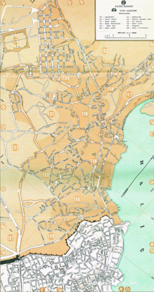
Eyüp has always been an important district of Istanbul. It increased in importance and development following the conquest of the city by the Turks in 1453. The original area of Eyüp expanded as the area between Eyüp Mosque and the Rami Barracks was a district which was significant as a pilgrimage location and an excursion area. To the east of the Rami Barracks is the Rami Cuma Mahalle which was a densely populated residential area settled by Turks who had migrated from Bulgaria in 1877-1878. The area extending from Eyüp Mosque towards the city walls to the south was also a residential area. In this period, the densely populated residential area to the north of Islambey Avenue did not yet exist. (Figure 2)
In 1934, there were twelve mahalles in Eyüp: Apdulvedut, Cezeri Kasım, Eyüp Sultan, Gümüşsuyu, İslambey, Fethi Çelebi, Düğmeciler, Nişancı Mustafapaşa, Üç Şehitler, Rami Cuma, Topçular and Rami Yenimahalle.19 Some of these mahalle names are different today. Of these, Apdulvedut,20 Cezeri Kasım,21 Üç Şehitler22 and Fethi Çelebi23 still exist as street names.
In the 1930s, one of the most important residential areas outside the city walls to the west was Bakirköy. Even though it was a region within the municipal borders in 1934, it was a residential area that was completely separated from the city of Istanbul. The Bakirköy of the time consisted of the area that includes the neighborhoods of Zeytinlik, Cevizlik, Yeni and Sakızağacı. A major part of the settlement was located in the area between the sea and the railway. (Figure 3) However, two sparsely populated residential areas, disconnected from one another, were to the north of the railway tracks. One of these was the area around the Bakirköy Train Station, the center of Bakirköy today. In this area, settlements were located in the areas around Bağlarbaşı-İncirli Road and on Terakki Street, close to the railway tracks. There was a corn field in the extremely wide area between Parkönü Street and the Veliefendi Hippodrome.24 The second residential area to the north of the railroad was the area known as Osmaniye Mahallesi (neighborhood) today, in addition to a cement factory.25 (Figure 3)
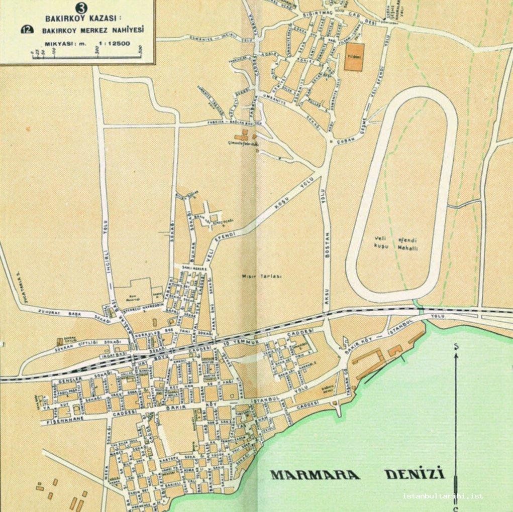
The Veliefendi koşu alan (running area), as it was known then, was outside the residential area of Bakirköy. There also was a farm, known as Şükran Çiftliği, close to the Bakirköy Station. (Figure 3) These were not residential areas. Today, Şükran Çiftliği Street marks this location.26
In the 1930s, Yesilköy, located to the west of Bakirköy, was a small residential area to the south of the railroad, between Çekmece Street to the west and Firuz Abdi (Havacı Muzaffer Erdönmez) Street to the east.
One of the leading areas outside of the Historical Peninsula where the city developed was the Golden Horn region. Settlements to the north of the Golden Horn extended along the coast. The most important residential area along the Golden Horn coast in this period was Kasımpaşa. The region of Kasımpaşa at this time consisted of Küçük Piyale, Camii Kebir, Kadı Mehmetefendi, Kaptan and Hacı Hüsam. The northern border of the settlement ended with the Mahalles of Kaptanpaşa and Hacı Hüsam (İstiklal). There were no settlements to the north of these mahalles. (Figure 4) Other residential areas were those of Hasköy, Halıcıoğlu and Sütlüce; they were on the northern coast of the Golden Horn, to the west of Kasımpaşa. In this region, the residential area extended along the coast, from Kasımpaşa to Sütlüce. The slopes behind the coast, which stretched to Okmeydanı, were not residential areas at this time.
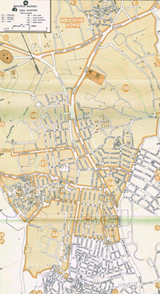
In 1934, the northern limits of the city ended where the Şişli Mosque stands today. This region formed the northern city limits. Being a small village at the time, Mecidiyeköy was surrounded by empty land. (Figure 5)
In the 1930s, the city on the European side only extended as far as Ortaköy along the Bosphorus. In other words, Ortaköy was the final point of the city on the Bosphorus. Ortaköy, which bordered Yıldız Park on the west and southwest, was connected to other city districts via Çırağan Street, Palanga Street and the Balmumcu-Ortaköy Road.
After Ortaköy there were a number of residential areas towards the north, along the Bosphorus coast. However, these were small settlements, almost stranded along the coast; examples include Arnavutköy, Bebek, Yeniköy, İstinye, Tarabya and Büyükdere. Tarabya, İstinye and Büyükdere had road connection to the ridges behind them. However, there were no settlements along these roads. The largest of these regions, and at the same time the center of the district, was Sarıyer, which had a population of 10,776 in 1935. Sarıyer consisted of the Yeniköy, Maden and Merkez mahalles. However, these three mahalles were separated from one another. The Bosphorus districts mentioned were not officially part of the urban structure until the 1930s. However, they were districts that fell within Istanbul’s sphere of influence and thus had a connection with the city.
On the Anatolian side, the city of Istanbul during the 1930s consisted of Üsküdar and Kadiköy and their surroundings. The residential area began at Kuzguncuk, to the north of Üsküdar, extending towards the south until Kadiköy; from here it extended to Bostancı to the east. However, there was a sparse residential structure between Kurbağalı Creek and Bostancı.
Üsküdar, which was the most important residential area on the Anatolian side, was a continuous residential area from Nuhkuyusu Street in the east up to the İcadiye-Bağlarbaşı Road. (Figure 6) However, the eastern parts of the aforementioned road did not have a dense residential population.
Kısıklı was a residential area to the east of Üsküdar at this time, located far away from the city. However, the immediately surrounding districts, such as Bağlarbaşı, Büyükçamlıca, Küçükçamlıca, Bulgurlu and Libadiye were sparsely populated residential areas.
The residential area to the south of Üsküdar in the 1930s extended up until Karacaahmet Cemetery and the Selimiye Barracks. İbrahimağa Mahalle of Kadiköy, located more to the south, was a residential area that was so sparsely settled that it could be said to be virtually non-existent. Acibadem Mahalle immediately to the east was much the same. (Figure 7)
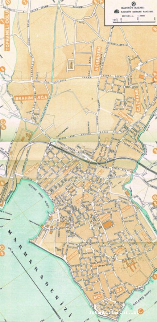
Another important residential area on the Anatolian side was Kadiköy. In the 1930s, Kadiköy consisted mostly of the area located to the south of the Haydarpaşa-Bağdat railroad. Kadiköy’s core residential area extended up to Haydarpaşa Station to the north and to Kurbağalı Creek to the east. In the neighborhoods of Acıbadem, Kaptanpaşa and Gazhane the residential area spilled over to the north of the railway. The residential population was sparse in this region, particularly in the Acibadem area. Kadiköy, limited by the sea to the south and west, was a continuous residential area within the boundaries mentioned above. (Figure 7)
The residential area of Kadiköy extended from the east of Kurbağalı Creek, along the railway line and went as far as Bostancı. (Figure 8) Merdivenköy and Sahrayıcedit, located to the north of this line, were residential areas that extended towards the north. In this region, residential areas could be found to the north and south of the railway line; however, there was a greater population density to the south. The most significant residential area in this region was the area between the railway and Bağdat Avenue, which runs parallel to the former.
Along the Anatolian coast in the 1930s the city ended at Kuzguncuk. However, there were Bosphorus settlements along the coast to the north. These were mostly small settlements established in the area where the river valleys opened into the Bosphorus. Beykoz in the 1930s, the largest of these, consisted of two mahalles, in specific Merkez Mahalle and Yalıköy. In 1935, Beykoz was a settlement with a population of 10.335. Çubuklu, Kanlıca, Anadoluhisarı and Kandilli were other small settlements along the coast in this period. The aforementioned settlements extended along the coast, and there were no significant developments towards the ridges or slopes behind them. Of these areas, Anadoluhisarı consisted of two mahalles, one to the north of the Göksu Brook, the other to the south. The one in the north was known as Anadoluhisari, the one to the south was Yenimahalle.
The residential area of Çengelköy, located on the Anatolian coast of the Bosphorus, was wider than those to the north. The northern and southern parts of Bekârdere Street, which acted as the main avenue connecting the coast to the ridges behind, was vacant land with no settlements; these were known as the Çengelköy Bostanlar (gardens). These gardens, which are densely populated residential areas today, were where the famous cucumbers known as Çengelköy bademi (almond) were grown. Çengelköy and Beylerbeyi were distinct and had not yet converged in this period. Even though the Beylerbeyi and Küplüce mahalles were connected to one another, the Burhaniye mahalle was still separate.
Istanbul in 1955
In 1935, Istanbul was a city with a population of 741.148.27 However, with the migrations that increased from 1950 onwards, the population within the borders of the municipality exceeded one million for the first time and in 1955, the population reached 1.268.771.28 Such an increase meant the addition of new residential areas to the city. In fact, when the residential areas of 1934 and 1955 are compared, it can be seen that new residential areas emerged, particularly around Eyüp, Şişli and Zeytinburnu; the city increased its land area in these regions. New areas that joined the city in the 1950s were the Taşlıtarla area in Eyüp; Alibeyköy and Sağmalcılar; Kâğıthane in Şişli; Levent in Beşiktaş; and the Koşuyolu district of Kadıköy..
Kâğıthane, one of the new development areas of the city, was a village in the ilçe (township) of Beyoğlu, with a population of 1,431 in 1950. Kâğıthane became a village with a population of 22,818 in 1960. In the ten intervening years, the population of Kâğıthane increased by sixteen times. It can be understood that the population increase and spatial development during these years was not simply limited to Kâğıthane. Changes were also made to the administrative structures of the city, with the Şişli district being established in 1954. The population increase and this change in the administrative structure bring to light the development that was occurring in the city’s districts.
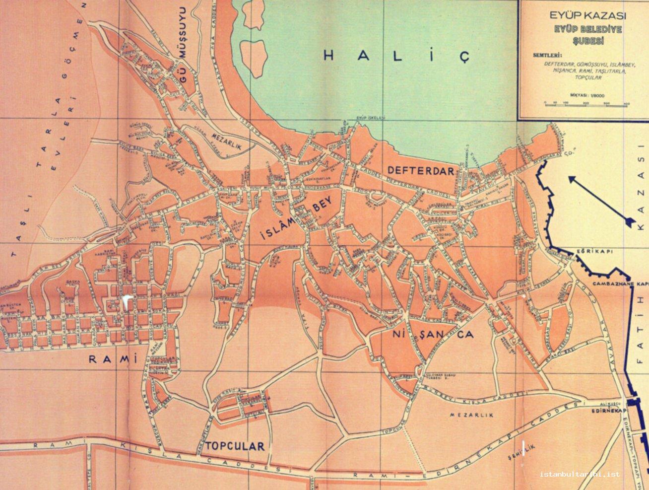
According to the data, Eyüp, a sub-district center in the township of Fatih, had a population of 22,398. Eyüp reached a population of 33,527 in 1950, and 52,132 in 1955. During this process, Eyüp became an ilçe center in 1936. One of the leading causes for the increase in population here was the settlement of Balkan immigrants during the 1950s. Migrants were settled in housing constructed in the Taşlıtarla Mahalle of Eyüp. This area is known as the Taşlıtarla Göçmen Evleri (migrant houses).29 (Figure 9) The residential area lies between Karlıtepe and Sarıgöl in what is today Gaziosmanpaşa. This area still carries traces of this settlement today, with its unique street system as compared to the streets of neighboring regions, particularly to the south of Gazi Muhtarpaşa (Ordu) Street. Moreover, Göçmenler (immigrants) Street in Karlıtepe also indicates this immigration.30
Eyüp was not just a residential area for immigrants coming from abroad; it was also a place preferred by migrants who came to Istanbul from various parts of the country. The leading mahalles in which migrants settled were Taşlıtarla, Alibeyköy and the surrounding areas. The increasing population and the new mahalles that appeared as a result of migrants taking up residence meant that changes in the administrative structure became necessary; towards the end of the 1950s the new bucak (sub-district) of Göktepe was established in the ilçe of Eyüp. The center of this region was Taşlıtarla. According to data from the 1960s, the population of Taşlıtarla, a bucak, was 54,544.31 The industrial facilities established in the immediate area also played an important role in the increase of population. Taşlıtarla, which appeared on the map with the population increase and the emergence of the gecekondu settlements from the 1950s onwards, constituted the nucleus of the Gaziosmanpaşa ilçe, which was established in 1963. One of the other districts that developed in the ilçe of Eyüp during those years was Alibeyköy. The population of Alibeyköy, which was 2,156 in 1950, increased to 12,819 by 1955.
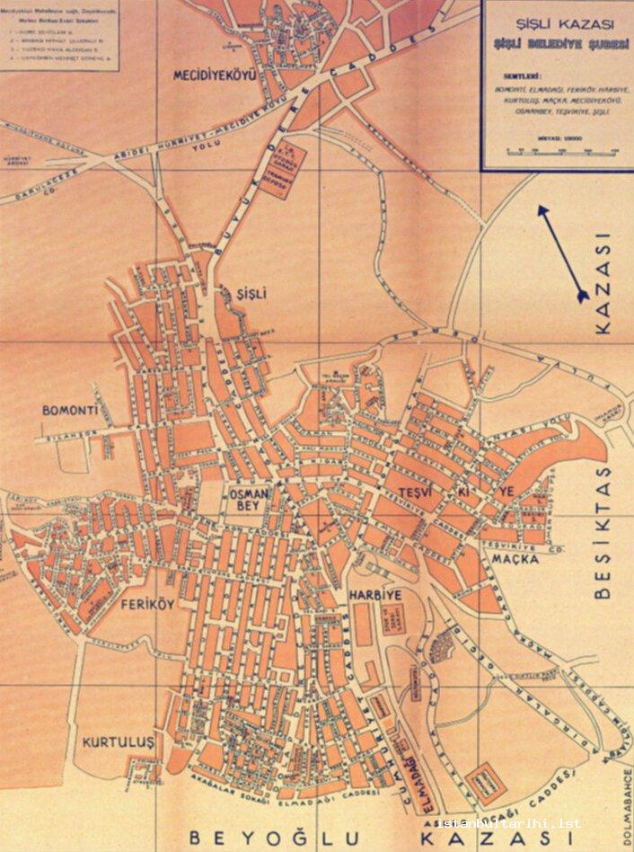
Şişli, which was a nahiye of Beyoğlu ilçe, had a population of 40,832 in 1935. In 1955, however, it became an ilçe with a population of 120,811. At this time, Şişli consisted of Şişli - the central residential area- and the mahalles of Osmanbey, Maçka, Teşvikiye, Harbiye, Elmadağ, Feriköy, Bomonti and Mecidiyeköy. The population increase in the area, which was one of the basic factors that led to the change in the administrative structure, was due to the emergence of new residential areas. While in this period limited development occurred in the Bomonti region, the city rapidly expanded towards Mecidiyeköy over Büyükdere Street. New areas with different uses emerged along Büyükdere Street, such as the İETT bus garage and tram depot.32 The neighborhood of Mecidiyeköy was connected to Şişli and became a mahalle of Şişli. (Figure 10) In addition, Zincirlikuyu was connected to Mecidiyeköy Mahalle through a newly established street system.33
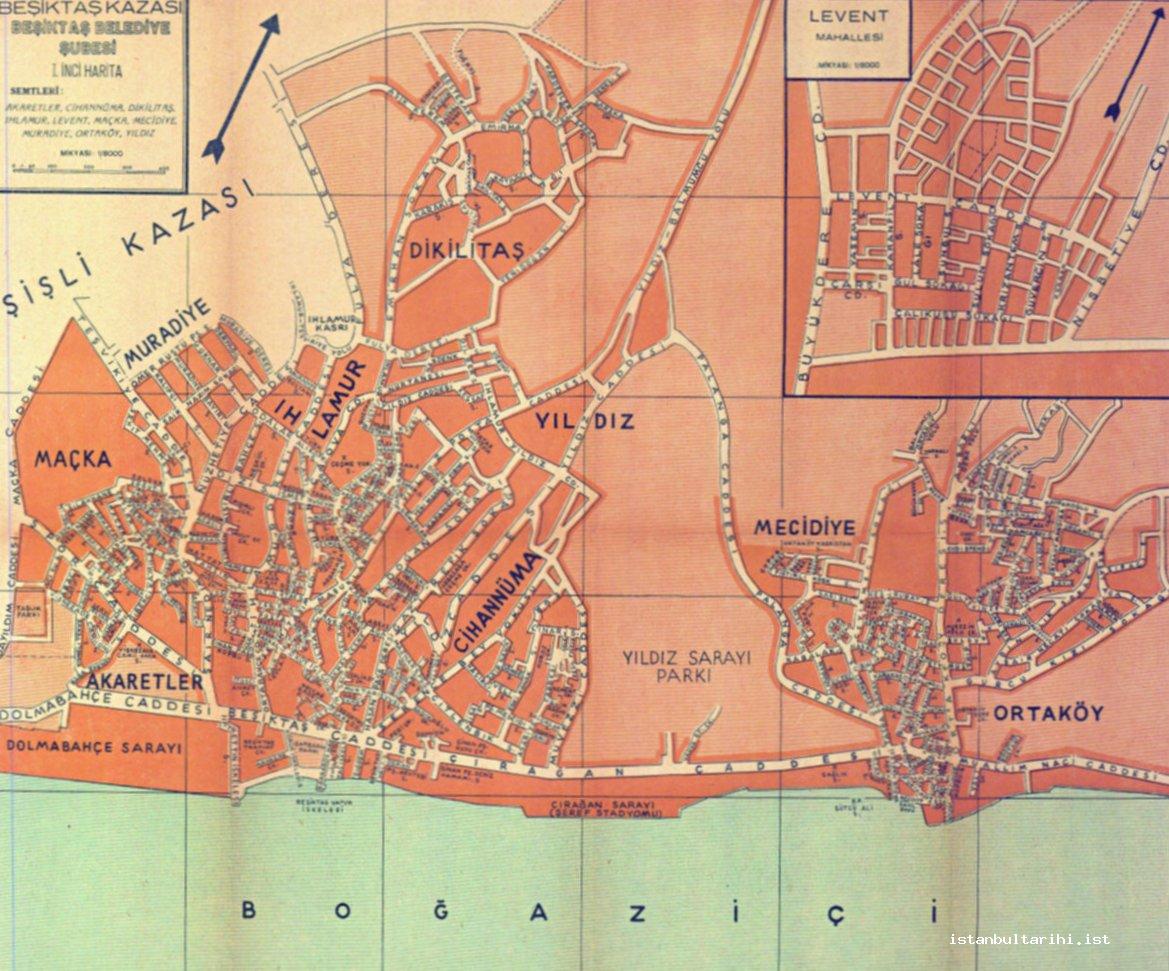
At this time (1955), one of the residential areas listed in the city plan is the mahalle of Levent. Levent was a residential area that was established as a result of the development that began with the construction of public housing in the 1940s. Levent Mahalle was established on farm land that was given to Hasanpaşa, an admiral of the Ottoman navy, by Sultan Abdülhamid I.34 According to the city plan of 1955, Levent consisted of the area between Büyükdere Street to the west and Nispetiye Street to the east.35 (Figure 11)
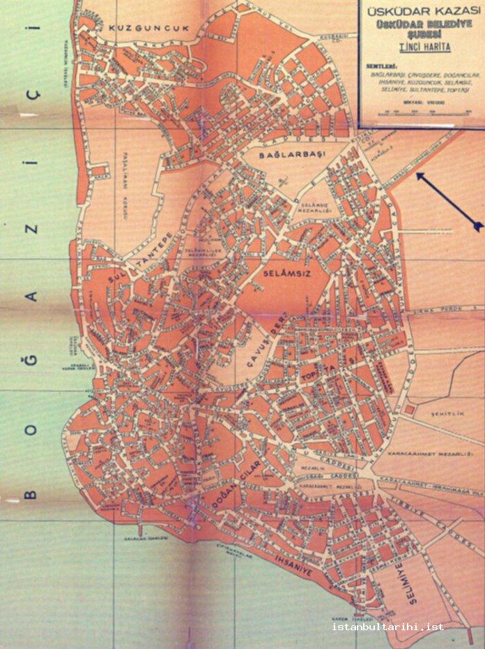
Üsküdar, an important residential area on the Anatolian side, in 1955 extended from Selimiye to the south, to Çengelköy to the north. However, a sparsely populated residential style was dominant in Beylerbeyi and Çengelköy, and the connection with Üsküdar was along the coast. There were no connections over the hills above the coast at this time. Nuhkuyusu Street and İcadiye-Bağlarbaşı Road, the continuation of the former, constituted the eastern border of the settled area in Üsküdar. (Figure 12) The vicinity of Karacaahmet Cemetery, which was outside this route, had not yet fully developed as a residential area. At this time, Üsküdar consisted of the mahalles of Selimiye, İhsaniye, Doğancılar, Toptaşı, Çavuşdere, Selamsız, Sultantepe, Bağlarbaşı, Kuzguncuk, Abdullahağa, Burhaniye, Küplüce, Beylerbeyi and Çengelköy.
The main residential area of Kadiköy, located on the Anatolian side, was the area between the coast and Kurbağalı Creek. In this area, Kadiköy consisted of the mahalles of Bahariye, Haydarpaşa, Moda, Mühürdar, Şifa, Yoğurtçu, Gazhane, Acıbadem and Koşuyolu. Of these, Koşuyolu was included as a new neighborhood in the Haritalı Şehir Rehberi (City Guide with Map), published in 1955.36 As a matter of fact, Koşuyolu did not exist in the İstanbul Şehir Rehberi from 1934. (Figure 13) Koşuyolu was established as part of the public housing project, constructed by the Emlak Kredi Bank in the 1950s. Hence, the residential area of Kadiköy extended as far as Koşuyolu Mahalle in 1955.
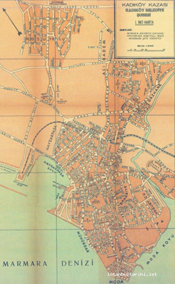
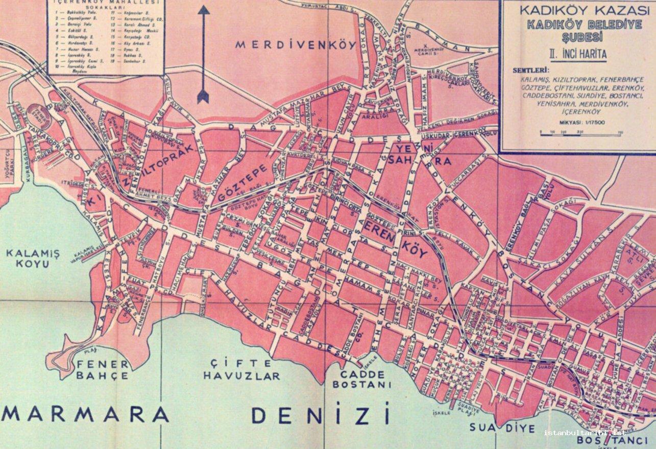
Another area that appears in the Haritalı Şehir Rehberi of 1955, but which was not present in 1934, is the Fener Stadium to the east of Kurbağalı Creek. Thus, it is possible to understand that Kadiköy had expanded a little to the east during this period. Moreover, the settlement structure in the area between Kurbağalı Creek and Bostancı in this period had become denser, and the area had extended a little north of the railway. By 1955, mahalles such as Kızıltoprak, Fenerbahçe, Göztepe, Çiftehavuzlar, Caddebostan, Erenköy, Suadiye, Bostancı, Yenisahra, Merdivenköy and İçerenköy were sparsely populated. (Figure 14)
Istanbul in the 1970s
Istanbul’s urban development was rapid after 1950 due to increasing migration and industrialization. In the 1970s, Istanbul had expanded its area to the west to Küçükçekmece, while to the east, the city extended continuously until Küçükyalı. Except for residential areas along the Bosphorus, Istanbul had expanded in the west to include Levent Mahalle. When compared with the perimeter of1955, Istanbul had reached a significant size in terms of land area. The effect of internal migration which took place after the 1950s played a significant role in this development. The city population, which was 983,041 in 1950, had increased to 2.132.407 in 1970. The population increase also had an effect on the administrative division of Istanbul. The number of ilçes within the municipal borders was ten in 1934, but by 1970 this number reached fourteen.37 In addition, in 1950, 47 % of the total population of Istanbul had been born in another province; this number reached 63 % in 1970. In other words, according to data from 1970, more than half of the population (63 %) in Istanbul had been born in another province - Istanbul was essentially a city of migrants. This data demonstrates the scale of migration that had occurred in Istanbul in the twenty years between 1950 and 1970.
The number of ilçes and mahalles is important in explaining the urban development of Istanbul in the 1970s. Within the municipal borders of Istanbul in 1970 there were fourteen ilçes: Eminönü, Fatih, Eyüp, Gaziosmanpaşa, Bakırköy, Zeytinburnu, Beyoğlu, Şişli, Beşiktaş, Sarıyer, Beykoz, Üsküdar, Kadıköy and the Princes’ Islands. At the time, the total number of mahalles was 326.38
Istanbul expanded from the beginning of the 1970s along the following lines: Istanbul encompassed an area that extended from Küçükçekmece in the west to Küçükyalı in the east.39 After encompassing Florya and Yeşilköy within its boundaries from Küçükçekmece on, Istanbul went north to Levent, extending over Bakırköy, Zeytinburnu, Bayrampaşa, Gaziosmanpaşa, Alibeyköy and Kâğıthane. At this point, the Sanayi, Yeşilce and Konaklar mahalles formed the northern border of the city. At the same time, the residential area extended until Sarıyer along the Bosphorus coast along a scattered and narrow strip. On the Anatolian side, the narrow strip between Beykoz and Üsküdar formed a similar settlement along the coast. In this section, the city increased in density towards the south from Çengelköy onwards.
The residential area on the Anatolian side increased in density to the north of Üsküdar, from Çengelköy onwards, continuing until Ümraniye to the east. At the time (1970), a sparse residential structure existed around Bulgurlu and Acıbadem. The area to the east of Acıbadem, broadly speaking south of the Ankara Highway (E-5) up until Küçükyalı, was a residential area. To the north of the Ankara Highway, only İçerenköy was included as a residential area.
Istanbul spread on the European side in the 1970s to the land between the sea and the Londra Highway (E-5); this continued towards the west from Topkapı. As stated above, in the mentioned area the city extended until Küçükçekmece. Here, the northern border was roughly formed by the E-5 Highway. To the north of this road, the districts of Bahçelievler, Tozkoparan and Maltepe developed. Of these, Tozkoparan and Maltepe were remarkable for their large number of industrial facilities. Yenibosna, Kocasinan, Bağcılar, Güngören and Esenler were to the north of these districts. However, these districts were not yet fully integrated with the city. Accordingly, while Istanbul extended from the historical city walls up to Küçükçekmece in the west, the real development of the city took place in the area between the coast and the E-5 Highway.
It can be seen that the city developed spatially more along the Marmara, Golden Horn and Bosphorus coastline during the 1970s; not much development took place in the inner parts. The city extended mostly towards the inner parts along the Golden Horn coast. Yıldıztabya, Esentepe and Bağlarbaşı, a mahalle that is part of Gaziosmanpaşa today, were the final points to which the city extended inland along the Golden Horn coast. The residential area along the Marmara coastline, extending from Eminönü to Bakırköy and Zümrütyuva mahalles, spread inland, mostly towards Bahçelievler, Tozkoparan and Maltepe mahalles. On the Anatolian side, Kısıklı to the east of Üsküdar and İçerenköy mahalle in Kadıköy were residential areas that were located further inland. As one moved inland from these districts, the rural areas, with villages and farms, began.
In the 1930s, the residential area of Eyüp, one of the older districts of Istanbul, was not greatly developed. The urban growth of settlements in Eyüp gained momentum after the 1950s. New residential areas to the north and west of Eyüp emerged during the 1970s. The area located to the northwest of Eyüp, known as the Taşlıtarla Göçmen Evleri area and its vicinity, were fully covered with residential areas. The housing of Balkan migrants and migration from within the country in later years initiated the rapid urbanization of this area, which at the beginning of the 1950s had been empty. The rapid development of residential areas in Taşlıtarla, located on the borders of Eyüp, resulted in the establishment of the Gaziosmanpaşa ilçe in 1963. In the 1970s, Gaziosmanpaşa became the city’s outer limit, marking the city borders in these parts.
The urban development of the areas surrounding Eyüp was not limited to this. The area around the Rasim Barracks, to the west of Eyüp, filled with residential areas. While the east of the barracks had been a residential area in the past, in 1970, residential areas now extended west of the barracks, and formed Sağmalcılar (known as Bayrampaşa today). In 1955, Sağmalcılar was a village with a population of 4,932. The population reached 29,110 in 1960; 69,064 in 1965; and 125,085 in 1970. Sağmalcılar’s population increased rapidly and it grew physically, developing in a short time and becoming one of Istanbul’s new districts. In the 1970s, Sağmalcılar became the outer limit of this part of the city. The selection of the area as an industrial park and the settling of migrants from Bulgaria and Yugoslavia here played the crucial role in the development of the district. Sağmalcılar, which had numerous industrial facilities operating in various fields (cotton, shoes, tires and engine factories) in the 1970s, is still a large industrial area today.
The city had expanded over a wide area to the north of the Golden Horn in 1970. In 1955, the residential areas along the Golden Horn coast were Kasımpaşa, Hasköy, Halıcıoğlu and Sütlüce; it expanded towards the north and the ridges of Okmeydanı along with the surrounding area of Piyalepaşa Boulevard, which ran between today’s Kasımpaşa and Çağlayan, was fully residential. The urban development of the city to the north of the Golden Horn had gone as far as Çağlayan to the north, over the hills of Kasımpaşa and Okmeydanı. In other words, the area between the Golden Horn (Haliç) Bridge, Okmeydanı, Çağlayan and the first circular road was filled with settlements. The industrial facilities along the northern shores of the Golden Horn and in the district of Bomonti had a large effect on the rapid emergence of this area as residential. While these developments were being experienced to the south of the Haliç Bridge-Mecidiyeköy line of the circular road, residential areas made rapid expansion to the north of this road. The residential area that expanded to Sütlüce along the Golden Horn coast in 1955 expanded north, following the Golden Horn shoreline and reaching Kâğıthane; from here it expanded east, up to Çağlayan, Gültepe and Levent. As a result, the north of the Haliç Bridge-Mecidiyeköy line of the circular road was also fully occupied with residential areas by the beginning of the 1970s.
The area between the Golden Horn to the west and the Bosphorus to the east was a residential area at the beginning of the 1970s. In this part, the area that went as far as Kâğıthane from the shores of the Golden Horn to the İETT Garage in Levent was completely residential. The area extending between the Sanayi and Yeşilce mahalles to the north of the İETT Garage, and to the Levent and Konak mahalles along the Şişli-Büyükdere Street made up the northern border of the urban development in the north. From this point on, there were no areas that were occupied before the soap factory at the point where the Şişli-Büyükdere street separated from Maslak towards the direction of Büyükdere and İstinye. During this period (1970), the residential area of Etiler and Levent, located to the east of the road, expanded and connected with Bebek, located on the Bosphorus coast.40
Beykoz was the northern border of residential areas on the Anatolian side. Beginning with Orta Çeşme to the north, continuing to the south via the Yalıköy and Merkez mahalles, the residential area in Beykoz extended towards Gümüşsuyu, İncirliköy, Çiğdem and Paşabahçe. The industrial facilities at Beykoz and Paşabahçe had an effective role in the development of settlements in this area. The residential area that went as far as Paşabahçe extended narrowly along the coastline to the south in the Çubuklu, Kanlıca, Anadoluhisarı, Kandilli and Vaniköy section. However, the residential area widened in areas along the Kanlıca and Anadoluhisarı ridges, towards Kavacık.
During the 1970s Üsküdar, an important residential area on the Anatolian side, extended continuously to the south, beginning from Selimiye and following the Bosphorus coastline all the way to Kandilli.
Nuhkuyusu Street and İcadiye-Bağlarbaşı Road were the eastern limits of Üsküdar for many years. As was the case in 1934 and 1955, this line was also the eastern border at the beginning of the 1970s. At this time, the area to the east of this line, beginning at Karacaahmet Cemetery in the south, and continuing to the north as far as Beylerbeyi, via Altunizade, Bağlarbaşı, Burhaniye and Nakkaştepe, was not yet a densely populated residential area. Kısıklı, Bulgurlu and Ümraniye, to the east of this area, had not yet been integrated with Üsküdar. The area between Üsküdar and Ümraniye, formerly sparsely populated, now slowly began to fill up.
The residential area in Kadiköy at the beginning of the 1970s consisted of the mahalles of Rasimpaşa, Acıbadem, Hasanpaşa, Caferağa, Osmanağa, Fenerbahçe, Göztepe, Fikirtepe, Yenisahra, Kozyatağı, İçerenköy, Caddebostan, Suadiye, Bostancı and Küçükyalı. At the time, the residential area extended from Kadiköy to the north, all the way to the lower slopes of Küçük Çamlıca Hill. In this part, settlement took place around Acıbadem Street, which extended from Rasimpaşa Mahalle to Acıbadem Mahalle. One of the residential areas in Kadiköy at this time was Koşuyolu. The first seeds of Koşuyolu, which began developing to the east of Karacaahmet Cemetery and the north of Ankara Highway, were the public housing projects that were built in the 1950s. The district developed around the Koşuyolu Street in 1970. Due to its location between Kadıköy and Üsküdar, Koşuyolu became the district connecting these two ilçes. The area of Koşuyolu expanded from the time of its establishment onwards and over time became integrated with the Barbaros Mahalle of Üsküdar to the west and Acıbadem Mahalle of Kadıköy to the south. However, it had not yet developed at the beginning of the 1970s. This integration would take place in later years.
As explained previously, the expansion of the city between Kadıköy and Bostancı in the 1930s and 1955s was primarily along the area between the coast and the railway. Between these dates the settled area extended to the north of the railway and expanded until Ankara Highway. By the 1970s, the area between Ankara Highway and the sea was fully occupied with residential areas. Only two empty pieces of land existed in this area: one is what forms the Dumlupinar Mahalle today, between Göztepe exit and Uzunçayır, while the other is the İbrahimağa quarter in Acibadem Mahalle. Only these two areas were not populated in Kadiköy in 1970.
The city continues to the east, without interruption, from Kadiköy all the way up to Küçükyalı. Maltepe, located further east, was not yet integrated with the city at the beginning of the 1970s. Maltepe was under the administration of the Kartal ilçe in 1971 and Kartal was outside the municipal borders at this time. 41
The 1970s was a period when the settlements along the Bosphorus grew, stretching up to the ridges behind the coastline. An important reason for such development in Büyükdere was the facilities established here, such as the Tekel match factory and the brick and tile factory that belonged to Yapi Kredi Bank. The residential area at İstinye Bay had also expanded somewhat, and while İstinye and Yeniköy were separate residential areas in 1934, it can be seen that they had converged by 1970. Industrial facilities such as match, cable and textile factories, as well as the İETT factories were established in the area, encouraging settlement around the bay.
As was the case in the west of the Bosphorus, by the 1970s it can be seen that settlements along the ridges above the Bosphorus to the east had also expanded, reaching down to the Bosphorus shores and converging with the settlements along the shores. The areas where the greatest development took place along the Bosphorus ridges in this period are the Beylerbeyi, Çengelköy, Anadoluhisarı and Kanlıca slopes. Developments on the ridges above the Bosphorus could be found in Kirazlıtepe, Çengelköy, Güzeltepe and Bahçelievler, located on the ridges behind Beylerbeyi and Kavacık and Anadoluhisarı and Kanlıca, respectively.
Istanbul in the 1990s
One of the periods in which Istanbul demonstrated spatial growth was between 1985 and 1995. One of the basic reasons for this development was rapid population growth. Within municipal borders, the population of Istanbul reached 5.475.982 in 1985, 6.620.241 in 1990 and 8.390.201 in 1997.42 Migration to Istanbul played an important role in this increase. Istanbul as a province during the period between 1985 and 1990 received 995.717 migrants. This was the greatest migration to the city between 1975 and 2000.43 The people who arrived in Istanbul generally settled in the newly developed areas on the outskirts of the city; as a result, new residential areas were added to the city.
Migration played an important role in the population increase, which brought with it a need for housing; new residential areas began to appear around various districts of the city, thus causing new and rapid growth.
The migration and population increase experienced after 1980 played an important role in the establishment of industrial areas like İkitelli, Tuzla and Dudullu, as well as contributing to the opening of the Fatih Sultan Mehmet Bridge and the second highway to deal with the traffic; in addition, new residential areas emerged on the Anatolian and Asian sides of Istanbul. Moreover, the rapid acceleration of the construction of social housing projects from the mid-1990s onwards added a new dimension to the city’s spatial developmental patterns.
The population increase and spatial developmental process experienced by Istanbul at the time also manifested itself in the city’s administrative structure: 14 new ilçes were established between 1987 and 1993, while 35 % of the ilçes that exist in Istanbul today were established in this period. Büyükçekmece, Küçükçekmece, Kâğıthane, Pendik and Ümraniye were established in 1987; Bayrampaşa in 1990; Avcılar, Bağcılar, Bahçelievler, Güngören, Maltepe, Sultanbeyli and Tuzla in 1992 and 1993. These newly established ilçes are important in terms of demonstrating the areas of the city that were developing.
In 1989, the city of Istanbul extended without interruption between Avcılar in the west to the Tuzla-Şifa mahalle in the east.44 According to this, the city had reached the furthest provincial border in the east.
While Istanbul extended only as far as Küçükçekmece to the west at the beginning of the 1970s, by the beginning of the 1990s the city had extended its area west of Küçükçekmece Lake.
According to data from 1971, only the mahalles of Bahçelievler, Tozkoparan and Maltepe existed in the area between Edirnekapı and Küçükçekmece along the E-5 Highway. However, in the following years, the city extended its area to the north of the E-5 Highway considerably. By 1990, Sefaköy, Yenibosna, Kocasinan, Güngören, Haznedar, Bağcılar and Esenler were new areas that joined the city to the north of the E-5 Highway. In addition to these new areas, the city also expanded to the east and west of Küçükçekmece Lake, and these new residential areas were added to the city. Areas west of the lake, consisting of Avcilar’s Firuzköy, Mustafakemalpaşa, Cihangir, Merkez, Üniversite, Denizköşler and Gümüşpala, and the İstasyon and Halkalı Merkez mahalles to the east of the lake, were integrated with the city. Most of the areas that became part of the city in the 1990s had been rural areas until that point in time. In 1960, Esenler was a village with a population of 3.482; Güngören was a village with a population of 3.070; Sefaköy’s population was 3.479 and Kocasinan’s population stood at 4.103. Istanbul’s urban development towards the west incorporated these aforementioned locations into the city and their administrative structure had changed. As a matter of fact, Küçükçekmece had become an ilçe in 1987; Avcılar, Bağcılar and Güngören were transformed into ilçes in 1992 and Esenler in 1993.
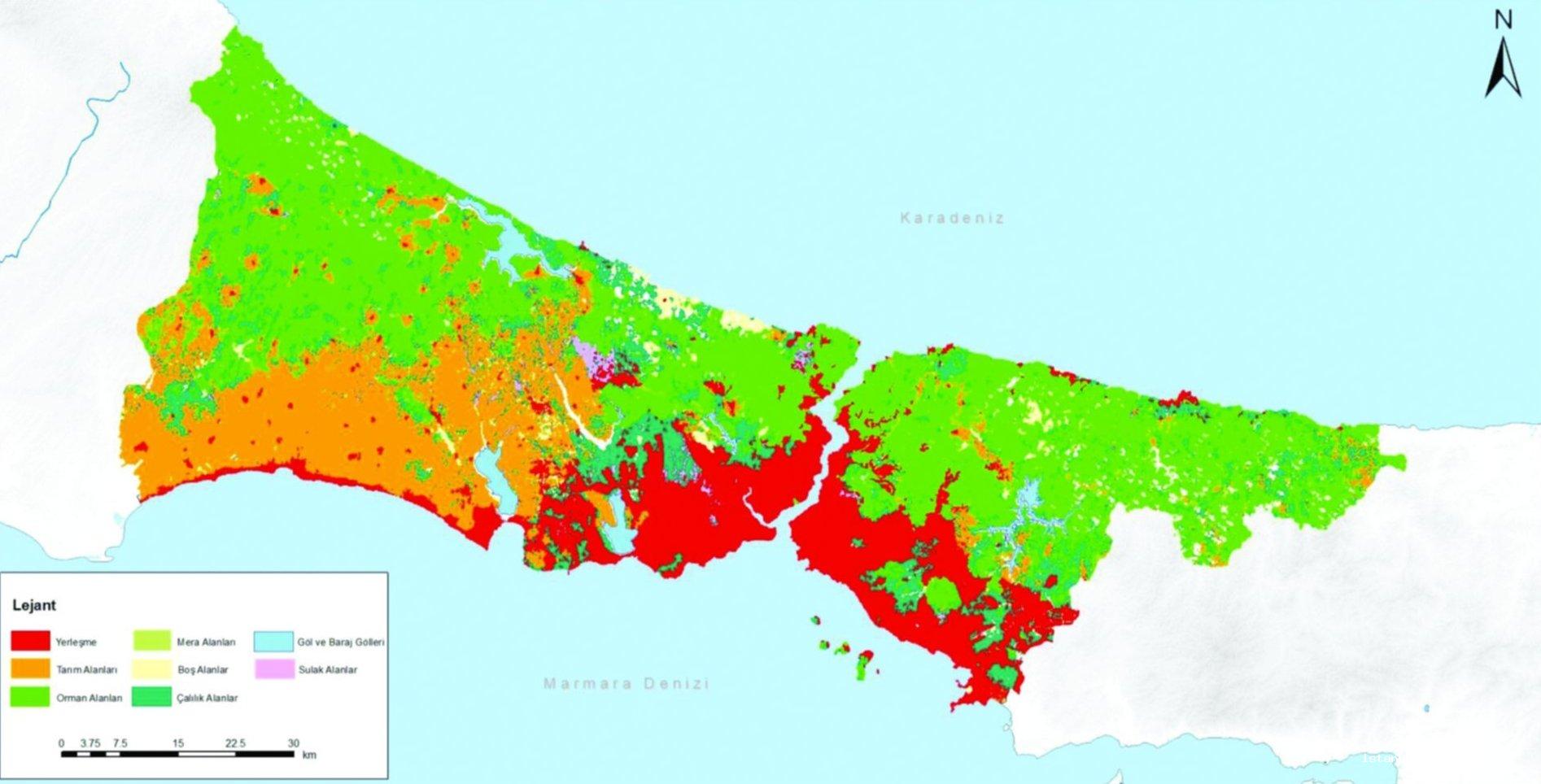
The 1990s were a period in which new residential areas on the Anatolian side were incorporated into the city. One example is Kavacık, coming to the fore as a growing residential area located at the foot of Fatih Sultan Mehmet Bridge on the Anatolian side. Kavacık was home to rapid spatial development, particularly following the opening of Fatih Sultan Mehmet Bridge to traffic in 1985.
Üsküdar’s Yavuztürk, Ferah, Bahçelievler and Küçüksu mahalles were home to an intensive settlement process between 1985 and 1990 and are located in the immediate surrounding areas of Bosna Boulevard, which follows the slopes of the Bosphorus from Ümraniye down to Çengelköy and Kandilli. In certain areas here, the settlements on the slopes of the Bosphorus were connected with the settlements along the coast, creating an area that extended upwards towards the slopes of the Bosphorus.
One of the rapidly developing areas on the Anatolian side during the 1990s was Ümraniye and its surroundings. Kâzımkarabekir, İnkılap and Hekimbaşı in Ümraniye were mahalles that grew as residential areas. The city, which had extended up until Yamanevler in Ümraniye in 1970, experienced a spatial expansion to the east, encompassing Çakmak, Yukarıdudullu, Sarıgazi and Sultanbeyli until the 1990s. The establishment of the Dudullu Organized Industrial Area in 1983 played an important role in the development of residential areas. The development of the city from this aspect also affected the administrative structure; in 1987, Ümraniye became an ilçe and in 1992, Sultanbeyli became one.
One of the important areas to develop on the Anatolian side was the areas around Ataşehir, Kayışdağı and Ferhatpaşa. Residential settlement, which began here from the beginning of the 1980s, transformed these regions into a part of the city in the 1990s.
In 1970, Istanbul stretched until Küçükyalı to the east. Maltepe, Kartal, Pendik and Tuzla, located to the east of Küçükyalı, were settlements along the shore of the Marmara Sea and outside of Istanbul. Tuzla was a coastal settlement with suburban resort attractions. In 1970, Tuzla was an area with a population of 9.905, Pendik had a population of 2.479, Kartal had 35.381 residents and Maltepe had 32.196; all these areas were under the jurisdiction of the Kartal ilçe. However, Pendik became an ilçe in 1987, while Maltepe and Tuzla became ilçes in 1992. These establishments that lie along the coastline separately from each other were included in the city in 1980s. The area left between Maltepe, Kartal, Pendik and Tuzla initially developed between the coast and the Ankara Highway. The actual development of settlements to the north of the Ankara Highway took place from the beginning of the 1980s. The Ankara Highway was the main reason the settlements developed on the east to west line in this region.
One of the important areas of spatial development in the 1990s was Tuzla. Traces of this development can be seen in the administrative structure, with Tuzla becoming an ilçe in 1992. The establishment of the Organized Industrial Areas in Tuzla accelerated spatial development. The establishment of the Tuzla Leather Industrial Area (in Aydinli-Orhanli) in 1982, and the Tuzla Paint and Varnish Organized Industrial Area in 1989 in the Tuzla Industrial Area promoted settlement in the area in the 1990s. In 2000, the establishment of the Tuzla Marble Manufacturers (in Aydinli) and the Tuzla Organized Industrial Area (in Tepeören) contributed significantly towards ensuring the continuation of the area’s spatial development in subsequent years. The fact that the organized industrial areas in Tuzla were built around the highway (E-80), which was opened in 1989, caused Tuzla to extend towards the east. Hence, the area between the coast and Orhanlı, Aydınlı and Tepeören was the stage of rapid settlement after 1990; settlements extended towards the north. Tuzla, with its shipyards and organized industrial areas, became one of Istanbul’s important industrial areas; the building needs for the industrial facilities and those working in these facilities caused a rapid increase in construction. This urban growth took place by extending the area of settlement from the coast inland.
The 1990s were a period of urban development for Istanbul in which the growth of the city northwards became evident. For a long time, Istanbul had exhibited linear development along the E-5 (D-100) Highway, growing in the east-west direction; however, with the opening of the Bosphorus Bridge in 1973, the city’s development shifted slightly towards the north. The real development of the city towards the north took place with the opening of the Fatih Sultan Mehmet Bridge and the ensuing years in which the roads connecting to it were opened to traffic. The Fatih Sultan Mehmet Bridge was opened to traffic in 1988; the second highway and the construction of connecting roads took place in the following years. In this way, the city broke away from the influence of the Bosphorus Bridge and its connecting routes, and a new period began in the urban development of the city. New residential areas began developing in regions close to the second highway, the parts where the highway connected to inner-city traffic, and its immediate surroundings. As a result, the second bridge and the highway accelerated the physical development of Istanbul towards the north; new residential areas emerged in the inner parts and the city significantly extended its area to the north.
During the 1990s on the Anatolian side dense residential areas emerged towards the east of Ümraniye, particularly in the areas around Tepeüstü and Yukarıdudullu, and the northern parts of Sultanbeyli, Samandıra, Sarıgazi, Kartal, Pendik and Tuzla. In the areas mentioned above, new mahalles formed, and these became part of Istanbul in later years. With the effect of this change in urban development, in 1992, the ilçes of Maltepe, Sultanbeyli and Tuzla were established.
While new residential areas emerged during the 1990s on the European side of Istanbul in the northern sections of Kâğıthane, Gaziosmanpaşa and Bayrampaşa, as well as in Esenler, Bağcılar, Başakşehir, Küçükçekmece, Beylikdüzü, Avcılar and Esenyurt, older settlements also extended their areas towards the east. The establishment in 1992 of the ilçes of Avcılar, Bağcılar, Bahçelievler and Güngören was a reflection of the physical changes being experienced in the administrative structure.
Istanbul in the 2000s
According to data collected in1998, Istanbul spread across an area that extended from Büyükçekmece in the west to Tuzla in the east.45 On the European side, it extended to Rumelikavağı, located to the north of Sarıyer, to Büyükçekmece and spread out over Esenyurt, Bahçeşehir, Halkalı, İkitelli, Bağcılar, Esenler, Habibler, Cebeci, Sultançiftliği, Gaziosmanpaşa, Alibeyköy, Kâğıthane, Ayazağa, Maslak and Büyükdere. From here, on the other side of the Bosphorus, the city followed the Bosphorus shoreline towards the south from Beykoz, extending towards the inner parts of Kavacik, to the east of Acarköy and the Fatih Sultan Mehmet Bridge, up to Paşabahçe. From this point on, the city grew to encompass the area between the Bosphorus and the second highway in the east.
The area that remained between the Bosphorus and the second highway on the European side experienced dense residential settlement after 1985. In this region, both sides of the Bosna Boulevard (NATO Road) that ascended the slopes of Beylerbeyi and Cengelköy and its continuation, Zübeydehanim Street, which goes north, and Rasathane Street on the slopes of Kandilli were all rapidly filled with residential settlements. In this region, the residential area extended down the slopes above the Bosphorus, and converged with the coastal settlements that ascended the slopes. Thus, the residential area that remained squeezed along the Bosphorus coast as a result of the local topography, and which spread along the coast as a narrow strip, was able to extend. The crests behind Kandilli, Vaniköy, Çengelköy and Beylerbeyi are areas which developed in this manner.
The residential area spread out towards the south from Kavacik and widened, continuing until Tepeüstü, to the east of Ümraniye. The eastern settlement in this region was along the second beltway. The residential area, which extends and widens to the east from Tepeüstü onwards, extends over an extremely wide area up to Sultanbeyli via Yukarıdudullu, Sarıgazi and Samandıra. It extends over Kurtköy and Şeyhli, located to the southeast of Sultanbeyli, all the way up to Tuzla and the eastern border of the province.
One of Istanbul’s important areas of development on the Anatolian side in the 1990s consisted of Sultanbeyli, Samandıra and Sarıgazi. In 1985, Sultanbeyli was a village with a population of 3.741. However, as a result of migration to Sultanbeyli after this date, the population in 1990 reached 82.298, twenty-two times its former size. This number reached 175.570 in 2000. The reason behind such an increase in the population of Sultanbeyli in such a short time was migration. The need for housing by those who came to Sultanbeyli resulted in the rapid growth of residential areas. However, this growth took place haphazardly and without planning. These developments brought along with them a change in the administrative structure, and Sultanbeyli was separated from Kartal in 1992, becoming its own ilçe. Sultanbeyli’s physical connection with Istanbul occurred towards the end of the 1990s. The highway that passed through Sultanbeyli played an important role in the urban development and integration with other parts of the city. The Sultanbeyli segment of the highway was opened in 1989.
Two other important developmental areas in this region were Sarıgazi and Samandıra. These two residential areas were administratively united in 2008 and a new ilçe, Sancaktepe, was established. However, the urban development and population increase, which began in 1985, continued throughout the 1990s. The population which in 1985 had been 8.701 in Sarigazi, reached 48.466 in 2000. Samandira had been a village with a population of 5.817 in 1985, but reached a population of 61.852 by 2000. Sarigazi and Samandira merged with the city in the early 2000s.
To the west, the residential area of Istanbul today (2010) extends beyond Büyükçekmece. The eastern border of the city ends in Tuzla, where the Istanbul provincial border meets Gebze. Istanbul reached this border to the east towards the end of the 1990s. According to current data (2010), Istanbul has reached a significant size in terms of area. Döker states that in 2010 the city measured 89,977 hectares.46
When Istanbul’s development areas in recent years are analyzed (2000-2010), it can be seen that Güzelce and Tepecik, to the west of Büyükcekmece, Yakuplu and Gürpınar in Beylikdüzü, the northern parts of the Esenyurt and Küçükçekmece townships, and Başakşehir’s Kayabaşı region are dense residential areas. The urbanization and urban development in this area brought with it an administrative change. In recent years, these rapidly developing districts led to the establishment of the Başakşehir, Beylikdüzü and Esenyurt ilçes in 2008. Beylikdüzü and Başakşehir have played an important role in the urban development of Istanbul with public housing applications.
The leading residential areas that were added to the city on the Anatolian side in the period between 2000 and 2010 are Çekmeköy, Taşdelen, Alemdağ and Yenidoğan. Because of the ease of access that the Şile Highway (Ümraniye-Şile Highway) provides, this road has acted as the main axis for development in the area. The numerous housing complexes constructed in areas to the north and south of the highway in Çekmeköy, and the Merkez, Mimarsinan and Hamidiye mahalles have played an effective role in the development of residential areas here. The industrial facilities around Taşdelen and Alemdağ also played a role in this. Moreover, after the Marmara Earthquake of August 17, 1999, there was a demand for housing in the northern parts of Istanbul, which are built on more stable ground, thereby providing protection against earthquakes and greater distance from fault lines. These developments in turn had an effecton theurbanization of this area.
The development of the city in these areas poses a serious threat to forest areas and for the Omerli Reservoir, which provides half the drinking water of the city. The population in the region continues to increase with every passing day. The population of Cekmeköy in 1980 was only 1,938. It reached a population of 13.523 in 1990, and 37,502 in 2000. In 2008, Cekmeköy was combined with Taşdelen, Alemdağ and Ömerli, and became an ilçe. Cekmeköy, consisting of these areas, had a population of 163,525 in 2010. The rapidly increasing population, affected by migration to the city from the 1990s onwards, was influential in the 2000s, and Cekmeköy became an area with a significant population. Population increase also caused urban growth and Cekmeköy became a part of the city in recent years. Sancaktepe, located next to Cekmeköy became an ilçe in 2008. Even though both areas became ilçes at the same time, the urban development of Sancaktepe and its physical convergence with the city happened at an earlier date than that of Cekmeköy. Sultanbeyli is a similar ilçe, which was established in 1992. The aforementioned townships are locations where population increased from the 1990s onwards and urban growth occurred. In recent times, their urbanization has been rapid and they have joined the city.
When the urban borders of the city of Istanbul are analyzed, the area from Ümraniye (Tepeüstü) all the way to Tuzla is an uninterrupted residential area along the Anatolian side. At the center of this line is the TEM Highway. The entire area is residential except for the areas between the Marmara coast to the south and the TEM Highway to the north; topographically high altitude areas, such as Kayışdağı and Aydos; the military barracks in Maltepe (General Kenan Evren and Nurettin Baransel); the area to the east of the Sabiha Gökcen Highway and the area surrounding Tepeören. The only vacant area left on the Anatolian side of Istanbul where urban development can occur in the future is to the north. The existence of the Ömerli Reservoir to the north of the residential areas, however, is an obstacle for settlements advancing in this direction.
FOOTNOTES
1 Doğan Kuban, İstanbul Bir Kent Tarihi Bizantion, Konstantinopolis, İstanbul, Istanbul: Türkiye Ekonomik ve Toplumsal Tarih Vakfı, 2000, p. 392; Besim Darkot and Metin Tuncel, Marmara Bölgesi Coğrafyası, Istanbul: İstanbul Üniversitesi Coğrafya Enstitüsü, 1981, p. 120.
2 Mehmet Karakuyu, “İstanbul›un Mekânsal Gelişiminin Analizi,” 12.02.2013. http://dis.fatih.edu.tr/store/docs/karakuyu_istmekgelangkkxxSyS.pdf.
3 Arif Keçeli et. al., “Büyükçekmece ve Küçükçekmece Gölleri Arasındaki Sahanın Arazi Kullanım Değişimlerinin Şehir Planlaması Açısından Değerlendirilmesi”, Marmara Coğrafya Dergisi, 2008, no. 17, p. 143.
4 Kuban, İstanbul, p. 392.
5 Mehmet Fatih Döker, “İstanbul Kentsel Büyüme Sürecinin Belirlenmesi ve Modellenmesi”, doctoral thesis, Istanbul University, 2012, pp. 228, 229.
6 This data was obtained from the Istanbul Municipality Planning Administration in May 2013.
7 Somer Ural et. al., “Boğaziçi ve Çevresinde Yerleşme ve Kentleşme Olayları ve Sorunları”, İstanbul Boğazı ve Çevresi Sorunları Sempozyum Kitabı, Istanbul: Çevre Koruma ve Yeşillendirme Derneği Yayınları, 1975, p. 209.
8 K. Arıbaş, “İskân Sorunu”, Cumhuriyet’in Ellinci Yılında İstanbul’un İdari Sorunları Semineri, Istanbul: İstanbul Üniversitesi Hukuk Fakültesi Yayınları, 1973, pp. 83, 84.
9 Turkey 1/25.000, Constantinople Sheet, Published by G.S., G.S. no. 3055, Ordnance Survey, London: War Office, 1917.
10 Turkey 1/25.000, Constantinople Sheet.
11 Today’s Ümraniye.
12 Plan d’Ensemble de la Ville de Constantinople. Copyright by Société Anonyme Ottomane d’Études Et d’Entreprises Urbaines, Stamboul : Guédik-Pacha, 1922.
13 Today’s İçerenköy.
14 Turkey 1/25.000, Constantinople Sheet.
15 İstanbul Şehri Rehberi, Istanbul: İstanbul Belediyesi, 1934, map of township of Kadıköy, Kızıltoprak region, p. 30.
16 Hayrettin Lokmanoğlu, Haritalı Şehir Rehberi, İstanbul: Halk Basımevi, 1955, Eki: Kadıköy Kazası II. haritası.
17 Kuban, İstanbul, pp. 383, 384.
18 İstanbul Şehri Rehberi, 1934, p. 197.
19 İstanbul Şehri Rehberi, 1934, Map of Fatih County, Eyüp region, p. 9.
20 Yavedut Street and Yavedut Sultan Mosque are located in Defterdar Mahallesi. (İstanbul Şehri Rehberi, Istanbul: İstanbul Büyükşehir Belediyesi İstanbul Araştırmaları Merkezi, 1998, p. 180)
21 Cezri Kasım Akarca Çeşmesi Street and Cezri Kasım Mosque are located in the neighborhood of Nişanca. (İstanbul Şehir Rehberi, 1998, p. 180)
22 The name of a street in İslambey Mahallesi (İstanbul Şehir Rehberi, 1998, p. 149).
23 The name of a street in Defterdar Mahallesi (İstanbul Şehir Rehberi, 1998, p. 180).
24 Mısır Tarlası (corn field) Street can be found in this area today (İstanbul Şehir Rehberi, 1998, p. 321).
25 The cement factory was on Fabrika-Bağlarbaşı Street. Today, the name of the street reflects this history: Kurt Çimento Bağlarbaşı Street (İstanbul Şehir Rehberi, 1998, p. 321).
26 İstanbul Şehir Rehberi, 1998, p. 321.
27 1950 GNS Türkiye Nüfusu, İstanbul: İstatistik Genel Müdürlüğü, 1961, p. 35.
28 1970 GNS İdari Bölünüş, Ankara: Devlet İstatistik Enstitüsü, 1973, p. XXXIX.
29 Lokmanoğlu, Haritalı Şehir Rehberi, Eki: Eyüp kazası haritası.
30 İstanbul Şehir Rehberi, 1998, p. 149.
31 1960 Genel Nüfus Sayımı, Ankara: Devlet İstatistik Enstitüsü, 1963, p. 292.
32 Today this is where Cevahir Shopping Center is located.
33 The names of the streets in Zincirlikuyu are Merkez Bankası Evleri, Kore Şehitleri, Binbaşı Mithat Uluönlü, Yüzbaşı Kaya Aldoğan and Üsteğmen Mehmet Gönenç. (Lokmanoğlu, Haritalı Şehir Rehberi, Appendix: Şişli Township Map.)
34 Kuban, p. 388.
35 Lokmanoğlu, Haritalı Şehir Rehberi, Appendix: Beşiktaş Township, Map no. 1.
36 Lokmanoğlu, Haritalı Şehir Rehberi, Appendix: Kadıköy Township, Map no. 1.
37 İstanbul Şehir Rehberi 1971, Istanbul: İstanbul Belediyesi, 1971, p. I.
38 İstanbul Şehir Rehberi, 1971, p. 1. If the eleven mahalles on the islands, which are not integrated with Istanbul, are excluded, the number of mahalles integrated with the city is 315.
39 İstanbul Şehir Rehberi, 1971, pp. 29, 35.
40 İstanbul Şehir Rehberi, 1971, pp. 8, 12.
41 İstanbul Şehir Rehberi, 1971, p. I.
42 Genel Nüfus Sayımı: Nüfusun Sosyal ve Ekonomik Nitelikleri 1985, 34 İstanbul, Ankara: Devlet Istatistik Enstitüsü, 1988, p. 4; DİE, Genel Nüfus Sayımı: Nüfusun Sosyal ve Ekonomik Nitelikleri 1990, 34 İstanbul, Ankara: Devlet Istatistik Enstitüsü, 1993, p. 34; 1997 Genel Nüfus Tespiti İdari Bölünüş, Ankara: Devlet Istatistik Enstitüsü,1998, p. 12.
43 TÜİK, Genel Nüfus Sayımı 2000 Göç İstatistikleri, Ankara: TUİK Matbaası, 2005, pp. 11, 22-25, 27.
44 İstanbul Şehir Rehberi, Istanbul: İstanbul Büyükşehir Belediyesi, 1989, pp. 74, 75.
45 Döker, “İstanbul Kentsel Büyüme Sürecinin Belirlenmesi”, p. 45; İstanbul Şehir Rehberi, 1998, pp. 512, 513.
46 Döker, “İstanbul Kentsel Büyüme Sürecinin Belirlenmesi”,p. 228, 229.
